Hespecke
|
Hespecke
City of Lennestadt
Coordinates: 51 ° 9 ′ 25 ″ N , 8 ° 0 ′ 59 ″ E
|
||
|---|---|---|
| Height : | 321 m above sea level NHN | |
| Residents : | 38 (Jun 30, 2020) | |
| Postal code : | 57368 | |
| Area code : | 02721 | |
|
Location of Hespecke in Lennestadt |
||
|
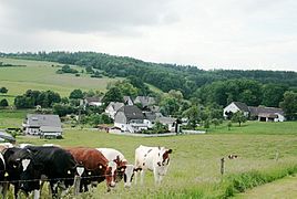
View of Hespecke
|
||
Hespecke is a district of Lennestadt , about 2.5 km west of Elspe and 0.8 km east of Sporke .
In its origins, Hespecke has a rural character, today there are still two full-time and one agricultural part-time farms. At the end of June 2020, 38 people lived in Hespecke.
The place is on the edge of the Attendorn-Elsper double trough . A dry valley leads from the Wietfeld plateau in the direction of Lenne . The surface water of this valley seeped into the karst crevices of the limestone reef and the Hespecker Cave, the Sporker Mulde and the Sporker Monarch Cave were created by the water flowing in the fracture system .
history
Hespecke (Harsebike) is listed in the property register of the Grafschaft monastery from 1269. In 1565, Harßbecke is mentioned in an extract from the Attendorn Go Court. The name Hespecke is probably derived from the Harse or Harße brook. The treasury register (used to collect taxes) from 1543 uses the place name Heerßbeck and lists 4 people liable for the treasury . If one equates the number of those liable for the treasure with the number of existing families or houses and calculates 6 residents per house, then around 1540–1550 around 25 people should have lived in Heerßbeck (Hespecke).
The place name contains the elements "-beke" (name of the water, here: Hespeckebach) and "-hers" (old Saxon: horse). According to Flöer, the place name could be interpreted as “horse stream”.
Above the village, the old "Bergstrasse" runs from Trockenbrück via Ostentrop to Arnsberg , which, along with the " Heidenstrasse " and the "Römerweg", is an important link.
At the ancient linden tree, which has a circumference of 400 cm, the old church path from Sporke via Hespecke to Elspe crosses the "Bergstraße".
In March 1957, near Hespecke, a large, surface-retouched stem tip made of milky-white, translucent flint was found, which can be seen in the South Sauerland Museum in Attendorn. Finds on the Hespecke plateau from the Neolithic indicate that Stone Age people lived here.
Old field names in Hespecke
On the trap-1635, Hundeborn -1635, that Kreuzacker -1635, on the Kuckelberge-1635, on the Langenschladen-1635, on the Maenschein -1560, on the Muhlhellen -1635, on the Rodde, in Senckell-1635, on the Steinacker -1635, Weit Feld -1530,1635, the Wortt-1635
literature
- Geological map NRW 4814 Lennestadt
- W. Schulte: Village history Sporke-Hespecke.
- Josef Brill: History of the Parish of Elspe. Olpe 1948, DNB 572530277 .
Web links
Individual evidence
- ^ Information from the city of Lennestadt
- ↑ Archive link ( Memento of the original from October 3, 2011 in the Internet Archive ) Info: The archive link was automatically inserted and not yet checked. Please check the original and archive link according to the instructions and then remove this notice. Page 74
- ↑ cf. Flöer, Michael, The place names in the Olpe district, Westphalian Place Name Book (WOB), Bielefeld: Verlag für Regionalgeschichte 2014, p. 131


