
High Bracht
| High Bracht | ||
|---|---|---|
 View from the northeast, from the western slope of the |
||
| height | 587.9 m above sea level NHN | |
| location | near Bilstein ; District of Olpe , North Rhine-Westphalia ( Germany ) / Ebbegebirge Nature Park , Sauerland | |
| Mountains | Bilsteiner Berge → Oberlennebergland → Südsauerländer Rothaarvorhöhen → Südsauerländer Bergland | |
| Coordinates | 51 ° 5 '0 " N , 8 ° 2' 23" E | |
|
||
| particularities | Hohe Bracht observation tower | |

The Hohe Bracht near Bilstein in the North Rhine-Westphalian district of Olpe is 587.9 m above sea level. NHN high mountain in the southern Sauerland mountainous region . The Hohe Bracht observation tower is on the mountain .
geography
location
The Hohe Bracht is located in the Bilsteiner Land between the villages of Altenhundem (zu Lennestadt ) at the confluence of the Hundem into the Lenne (northeast), Hofolpe (zu Kirchhundem ) in the Olpe valley (southeast) and Bilstein (zu Lennestadt) in the Veischede valley (northwest) ; its summit is in the Lennestadt area. The mountain is located in the Natural Park Sauerland Rothaar adjacent to the east adjacent Rothaargebirge . Past the Alperstein ( Alberstein ; 587.7 m ) located a little to the south, the mountain landscape leads over to the south-western Buscheid ( 599.2 m ).
Rising on the mountain: Windfart (north) as the Weiste tributary, Weiste (south-east) as the Hundem tributary and Burbecke (south-west) and Helsmecke (north-west) as tributaries of the Bremecker Bach , which flows into the nearby Veischede .
On the Hohen Bracht lies a part of the landscape protection area Kreis Olpe ( CDDA -Nr. 345041), which was founded in 1988 and is 262.87 km² .
Natural allocation
The Hohe Bracht belongs to the natural area main unit group Süderbergland (No. 33), in the main unit Südsauerländer Bergland (336 2 ) and in the subunit Südsauerländer Rothaarvorhöhen (336 2 .5) to the natural area Oberlennebergland (336 2 .52).
Mountain height and hilltops
The Hohe Bracht has two peaks about 345 m apart, between which there is a mountain saddle with a parking lot ( 577.7 m ) and a water reservoir next door : the southwest knoll ( ⊙ ) with the mountain summit at 587.9 m or, according to other information, 587.7 m height and the 582.1 m or other information, 581.2 m high north-east knoll ( ⊙ ), on which the Hohe Bracht observation tower stands.
Hohe Bracht observation tower

.jpg)
Tower description and history
At the highest point of the northeastern summit of the Hohe Bracht is the Hohe Bracht observation tower with an attached restaurant-café. It is considered the landmark of the Olpe district .
On June 22, 1929 or 1930, the construction of the 36 m high tower began, which was inaugurated on October 11, 1930. The building, which is colloquially known as "(the) Hohe Bracht", is completely clad with the slate typical of the regional architectural style .
The chairman of the founding committee formed on December 29, 1928 was Altenhundemer Ministerialdirektor Wilhelm Arnoldi (1884-1965). According to his ideas, the tower should have the purpose of bringing the beauty of the Sauerland closer to the local population and foreign wanderers. At the same time, it was hoped that tourism would be stimulated.
The radio broadcast of the opening ceremony on October 12, 1930 was an anniversary for West German Radio. “Here is the Langenberg transmitter . We'll be back with the broadcast of the celebration on the occasion of the inauguration of the observation tower on the Hohen Bracht near Altenhundem ” , was the announcement by the spokesman Dr. Ernst from West German Broadcasting. These were the first words that came from the Sauerland over the airwaves.
In 1931, a branch of the Bilstein Youth Hostel was set up on the Hohen Bracht . After 1933 it was initially converted into a HJ training home and later as a labor camp . During the chaos of war, the premises were mostly empty. From December 1944, the tower was used as a furniture store for the victims of the Möhne disaster .
During the Second World War , the building became the scene of fighting in April 1945. In 1947 the war damage was repaired and the building was reopened as a lookout tower and district youth home.
The observation tower and the outdoor facilities of the summit region were extensively restored in summer 2017. The innovations relate in particular to the catering area on the ground floor, the creation of a multifunctional area for open-air events and the renovation of the parking spaces and access roads to the tower. The expenditure was put at 2 million euros by the district of Olpe. The reopening took place in October 2017.
Possibility of viewing
The tower is a popular excursion destination because of the wide panoramic view from its observation platform: up to the outbreak of the World War, almost 30,000 visitors came every year and after that in 1954 it was 90,000.
One looks over large parts of the Sauerland, down to Bilstein (northwest) and Altenhundem (northeast), over to the Ebbegebirge (west-northwest), to the Lennegebirge (north), to the Saalhauser mountains (northeast) and to the Rothaargebirge (east; there to the Kahler Asten) ; with a tower of branches ).
.jpg)
Winter sports, hiking and culture
There are various winter sports facilities on the Hohen Bracht : an 800 m long ski slope with lift and floodlights, a toboggan run (all on and on the north-east summit ) and three cross-country trails with a length of 2.5 km to 13 or 19 km. However, the winter sports opportunities here, as in general in the German low mountain ranges, have been increasingly limited due to the decreasing snow reliability in recent years.
Several circular hiking trails with a total length of around 30 km lead over the mountain, some of which are connected to long-distance hiking trails - including the German Unity hiking trail leading over the mountain . With the help of the NRW Foundation , an approximately 1 km long, barrier-free exploration path with information boards, quiet zones and viewing bays was created near the tower.
Since 2005, every year on the Hohe Bracht on Friday after Corpus Christi one outdoor - rock music festival held with local bands.
Transport links
The state road 715 ( Altenhundem - Bilstein ) runs north past the Hohen Bracht , from which the district road 20 ( Hohe Bracht ) branches off at a height of 435 m and leads as a dead end through the forest up to the car park on the summit region.
gallery

Hohe Bracht, seen from Bilstein Castle

New access to the observation tower (April 2018)

renovated tower of the Hohen Bracht (April 2018)

View from the Hohe Bracht observation tower to Bilstein with Bilstein Castle
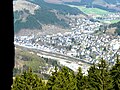
Tower view of Altenhundem with the valleys of Hundem (front) and Lenne (back)
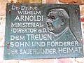
Memorial plaque Dr. hc Wilhelm Arnoldi (initiator of the tower)
.JPG)
.jpg)
.jpg)


Individual evidence
- ↑ a b c d e Map services of the Federal Agency for Nature Conservation ( information )
- ↑ Martin Bürgener: Geographical Land Survey: The natural spatial units on sheet 110 Arnsberg. Federal Institute for Regional Studies, Bad Godesberg 1969. → Online map (PDF; 6.1 MB)
- ↑ a b c d Topographical Information Management, Cologne District Government, Department GEObasis NRW ( information )
- ↑ a b c d e f g Information on Hohen Bracht ( Memento from April 11, 2012 in the Internet Archive ), on Hohebracht.de
- ↑ a b c Information according to the Hohen Bracht flyer ( Memento from February 21, 2014 in the Internet Archive ), on Hohebracht.de (PDF file; 1.19 MB)
- ↑ 50 years of Hohe Bracht , series of publications by the district of Olpe, issue 1, Olpe 1980, p. 30
- ↑ 50 years of Hohe Bracht , series of publications by the district of Olpe, issue 1, Olpe 1980, p. 36ff. and p. 41ff
- ↑ 50 years of Hohe Bracht , series of publications by the district of Olpe, issue 1, Olpe 1980, p. 52
- ↑ Hohe Bracht observation tower will reopen in mid-October , in: Westfalenpost , from August 29, 2017, accessed on September 1, 2017, at wp.de.
literature
- Dieter Tröps: 50 years of Hohe Bracht. Festschrift for the 50th anniversary of the observation tower on the Hohe Bracht . Ed .: The senior district director of the district of Olpe (= series of publications of the district of Olpe . No. 1 ). Olpe 1980.
Web links
- Hohe Bracht , in: Sights and destinations , on Kreis-olpe.de