Hochwald (Waldbröl)
|
High forest
City of Waldbröl
Coordinates: 50 ° 51 ′ 2 " N , 7 ° 37 ′ 49" E
|
|
|---|---|
| Height : | 310 m above sea level NN |
| Residents : | 35 (December 2, 2004) |
| Postal code : | 51545 |
| Area code : | 02291 |
|
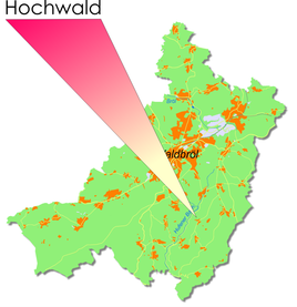
Location of Hochwald in Waldbröl
|
|
Hochwald is a village in the town of Waldbröl in the Oberbergisches Kreis in southern North Rhine-Westphalia ( Germany ) within the administrative district of Cologne .
Location and description
The place is about 4.8 km southeast of the city center.
history
First mention
The place was mentioned for the first time in 1555 , namely "Johan vom Hoewalt."
The spelling of the first mention was Hoewalt
leisure
Association
- SSV Hochwald
Hiking and biking trails
The A3 hiking trail leads through the high forest, coming from Vierbuchermühle .
Bus and train connections
Public bus
Stop: Hochwald
- 343 Waldbröl, Windeck-Rosbach / Schladern ( OVAG )
swell
- ^ Klaus Pampus: First documentary naming of Oberbergischer places (= contributions to Oberbergischen history. Sonderbd. 1). Oberbergische Department 1924 eV of the Bergisches Geschichtsverein, Gummersbach 1998, ISBN 3-88265-206-3 .

