
Hohenbergstrasse
| Hohenbergstrasse | |
|---|---|
|
|
|
 |
|
| Basic data | |
| place | Vienna |
| District | 12th district |
| Created | 1778 |
| Hist. Names | Gloriettegasse |
| Cross streets | Ruckergasse , Aichholzgasse, Theergasse, Schwenkgasse, Brockmanngasse, Arnsburggasse, Stranitzkygasse, Ludwig-Martinelli-Gasse, Tyroltgasse, Josefine-Wessely-Weg |
| Buildings | Meidlinger Trainkaserne , Am Tivoli , Indianerhof , Parish Church of St. Klemens Maria Hofbauer |
| use | |
| User groups | Pedestrians , bicycle traffic , car traffic , bus routes 8A 63A |
| Road design | avenue |
| Technical specifications | |
| Street length | approx. 990 m |
The Hohenbergstraße is located in the 12th Vienna district, Meidling .
Course and characteristics

The street runs in an east-west direction straight ahead from Edelsinnstraße near the Philadelphiabrücke to Maria-Theresien-Brücke over Grünbergstraße; Beyond the bridge is the Meidlinger Tor of the Schönbrunn Palace Park , in which an avenue continues straight ahead to the Gloriette . The road is on the same ridge as the Gloriette, the Green Mountain or the Meidlinger Höhe; to the north, the terrain drops off considerably from the road towards Wiental .
Hohenbergstraße is laid out as an avenue and has a cycle path. Almost its entire length is used by buses from lines 8A and 63A. There are stops at the corners of Ruckergasse, Aichholzgasse (at the Gatterhölzlkirche), Schwenkgasse and Stranitzkygasse.
The street mainly stretches between extensive, quietly located urban residential complexes. On the southern side of the street, in the central half of the street, there is a barracks area used by the police and the armed forces and extending as far as Edelsinnstraße, the former Meidlinger Trainkaserne .
history

The part of the street further away from the center was laid out in 1778 in the area of the later Viennese suburb of Meidling - as an avenue and as a visual axis to the eastern side of the Gloriette in Schönbrunn Palace Park . It was therefore given the name Gloriettegasse . At the end of the street on the park side, there are two sphinxes as sculptures on the Maria-Theresien-Brücke . After the incorporation to Vienna (1892), the street was renamed in 1894 , as the previous name was also used for a street extending the western axis of the Gloriette in the now neighboring district of Hietzing : after the architect Johann Ferdinand Hetzendorf von Hohenberg , who created the Gloriette 1772–1776 had built on behalf of Empress Maria Theresa .
Originally the road was in grassland. Here there were unspoilt meadows and a forest called Gatterhölzl , in which the Vltava Chapel from the time of the second Turkish siege of Vienna was located. In 1830 the entertainment establishment "Tivoli" was opened on the slope to the Wiental , which achieved local fame, but had a very eventful history and in 1967 had to be closed for good. It became an excursion destination from which one had a nice view down: first of the Biedermeier Vienna within its city walls, later of the rapidly developing city.
Further to the east, between Aichholzgasse and Ruckergasse, the Meidling slaughterhouse began operations in 1888 (on what will later be the northern side of the street) , which in 1953 had to make way for residential buildings. Around 1900 the street was extended eastward from Schwenkgasse, past the slaughterhouse, to Edelsinnstrasse, as the northern boundary of the area of the Meidlinger barracks built in 1904–1906 . In the interwar period of Red Vienna , extensive community buildings similar to those of a garden city (communal housing complexes) were built.
Remarkable structures
At the central (eastern) beginning of Hohenbergstrasse, between Edelsinnstrasse and Ruckergasse , on the north side is the site of the former Koppreitergasse tram depot, on the south side there is a small green area that used to be an urban children's pool.
Even house numbers: on the north side of the street; odd house numbers: on the south side of the street

No. 1: Meidlinger barracks
The extensive area of the former Meidlinger Trainkaserne lies between Ruckergasse and Schwenkgasse . It was built between 1904 and 1906 as part of the large-scale barracks transaction as a replacement for the Trainkaserne in Ungargasse and the Holzhofkaserne in Favoritenstrasse by the architects Rudolf Tropsch and Hans Prutscher . The representative entrance building with secessionist decor with two large horse sculptures is located at Ruckergasse 62. The adjoining eastern part of the area is used by the Federal Police. The western part, used by the armed forces, was named Heckenast-Burian-Kaserne in 1967 after two murdered Nazi opponents; At the entrance to Schwenkgasse 47 there is a memorial stone for Lieutenant Colonel Franz Heckenast and Captain Karl Burian .
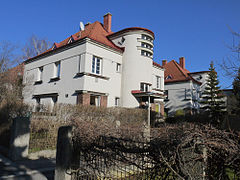
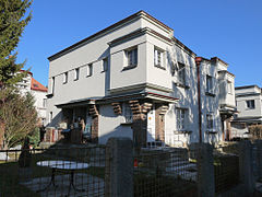
No. 3–23: Am Tivoli residential complex
At No. 3–23, on the southern side of the street, is the Am Tivoli urban residential complex . It was built in 1928–1930 according to plans by the architect Wilhelm Peterle and is designed in the style of the Viennese garden city movement. The site is laid out loosely and diversely and consists of two-storey two-family houses with gardens. In the middle of the facility is a larger building with a kindergarten. Today the Moldau Chapel stands between the residential buildings in Arnsburggasse; it was moved here from its original location a little further south in the course of the construction of the residential complex. At the chapel there is a bust for the Wallachian ruler Șerban I. Cantacuzino , who prayed here during the second Turkish siege of Vienna in 1683 in front of a cross he erected around which the chapel was later built. (The cross was stolen in 1785 and has not appeared again.)

1930

kindergarten


No. 14–16: urban residential complex

On the residential complex of the municipality of Vienna, which was built in 1951/1952 by the Vienna City Building Department, there is a stone entrance relief, "Mother with Children", created in 1953 by Adolf Treberer-Treberspurg.
No. 24–32: urban residential complex
The residential complex of the municipality of Vienna was built in 1949/50 according to plans by Franz Mörth. On the facade facing Hohenbergstrasse, two large sgraffiti created in 1949 by Otto Rudolf Schatz can be seen, which depict the four elements.


Sgraffito air and water

Sgraffito fire and earth


No. 34–40: Indian farm
Part of the so-called Indianerhof , a municipal residential complex from the years 1927–1930, is located on Hohenbergstrasse. The component was designed by the architect Camillo Fritz Discher , is similar to a garden city and consists of villa-like terraced and semi-detached houses.


No. 42: Gatterhölzlkirche
The Roman Catholic Parish Church of St. Klemens Maria Hofbauer is located on the so-called Meidlinger Höhe, an area that once belonged to the park of the Springer-Schlössl located below . In place of an emergency church built during the First World War, which had been a parish church since 1935, the current building was built between 1955 and 1959 according to plans by Ladislaus Hruska . The distinctive domed structure made of reinforced concrete is reminiscent of Byzantine forms.


No. 44–50: Julius-Raab-Hof
The residential complex was built between 1955 and 1961 according to plans by the architect Josef Vytiska and is named after Federal Chancellor Julius Raab († 1964).
No. 58: former Tivoli grounds
Here was the site of the former "Tivoli" entertainment establishment , which was built in 1830. A slide was attached. The highest circles of the imperial family and the nobility, as well as the upper middle class, took part in the large festivals held here. The background music was provided by the orchestra under the direction of Johann Strauss' father . Later, when the expensive company had to be closed, a dairy was built here, where artists like Gustav Klimt also frequented at the turn of the century . There were also carousels and amusement booths for the common people. Tivoli fell into disrepair over the course of the 20th century and finally burned down in 1980. A senior citizens' home was built in its place.
literature
- Dehio Handbook Vienna. X. and XIX. to XXIII. District . Verlag Anton Schroll: Wien, 1996
- Felix Czeike (Ed.): Hohenbergstrasse. In: Historisches Lexikon Wien . Volume 3, Kremayr & Scheriau, Vienna 1994, ISBN 3-218-00545-0 , p. 243 ( digitized version ).
Web links
Coordinates: 48 ° 10 ′ 33.6 ″ N , 16 ° 19 ′ 15.8 ″ E