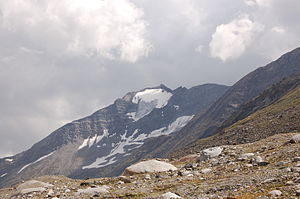
High Cross (Venediger Group)
| High cross | ||
|---|---|---|
|
The High Cross of the Umbal Valley (northeast) |
||
| height | 3159 m above sea level A. | |
| location | East Tyrol | |
| Mountains | Umbalkamm , Venediger Group | |
| Dominance | 1.4 km → Daberspitze | |
| Notch height | 164 m ↓ notch to Daberspitze | |
| Coordinates | 47 ° 0 '27 " N , 12 ° 13' 29" E | |
|
|
||
| First ascent | September 27, 1904 by I. Hechenbleikner and K. Berger | |
| Normal way | Over the Clarahütte and the Achselkörle and the east ridge | |
The Hohe Kreuz ( 3159 m above sea level ) is a mountain peak in the Umbal ridge of the Venediger group in the west of East Tyrol .
location
The Hohe Kreuz lies on a side ridge of the Umbal ridge, which branches off from the Daberspitze to the southeast. To the northwest, the Südliche Tredeberscharte separates the Hohe Kreuz from the Tredeberspitze ( 3134 m above sea level ), from the Hohe Kreuz itself the side ridge leads further east to the armpit . The south ridge drops off steeply to the Dabertal. The Hohe Kreuz is located in the municipality of Prägraten am Großvenediger .
history
The summit was named by Franz Keil , the first ascent took place on September 27, 1904 by I. Hechenbleikner and K. Berger. For a long time it was an insignificant peak in the shadow of the Rötspitze and Daberspitze, although it is the closest summit to the Clarahütte. At the beginning of the 21st century, however, local mountaineers set up a mighty summit cross on the Hohe Kreuz and marked an ascent path during the installation. The summit cross sends a ray of sunshine to Prägraten every year on December 21 (winter solstice) when the sun is shining.
Promotion opportunities
The normal route to the Hohe Kreuz is from the Clarahütte over the east ridge. To do this, after the Clarahütte, follow the path a little north to a bridge over the Umbalbach and then follow a marker that leads over a steep grass flank and then over moderately sloping slopes between the northeast ridge and the east ridge to the cirque des Achselkörle. The steep ascent to the east ridge ( UIAA I ) is followed by a slight final ascent to the summit.
A second variant for the ascent to the Hohe Kreuz is via the northwest ridge. Starting from the Neue Reichenberger Hütte , the ascent first follows the marked path over the Daberlenke in the direction of Clarahütte, until you can cross at a height of around 2,500 meters to a Hochkar between the Daberspitze and the Hohe Kreuz. This is followed by the ascent in the Südliche Tredeberscharte on the northwest ridge and a short climb ( UIAA II ) to the summit.
literature
- Georg Zlöbl: The three thousand meter peaks of East Tyrol in the Hohe Tauern National Park. Verlag Grafik Zloebl, Lienz-Tristach 2007, ISBN 3-200-00428-2 .
- Willi End , Hubert Peterka : Alpine Club Leader Venediger Group. Bergverlag Rother , 5th edition 2006, ISBN 3-7633-1242-0 .
- Alpine Club Map 1: 25,000, sheet 36, Venediger Group , ISBN 3-928777-49-1 .

