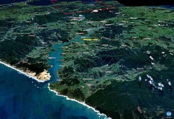
Houhora Harbor
| Houhora Harbor | ||
| Geographical location | ||
|
|
||
| Coordinates | 34 ° 48 ′ S , 173 ° 8 ′ E | |
| Region ISO | NZ-NTL | |
| country | New Zealand | |
| region | Northland | |
| Sea access | Rangaunu Bay , Pacific Ocean | |
| Data on the natural harbor | ||
| Port entrance | 150 m wide | |
| length | around 7.8 km | |
| width | Max. 2.3 km | |
| surface | 14.3 km 2 | |
| Coastline | 20 km | |
| Water depth | Max. 4 m | |
| places | Pukenui | |
| Tributaries | different small streams | |
| Islands | a 35 x 2 m island | |
| Jetty | Pukenui | |
| Photography of the natural harbor | ||
 Hokianga Harbor (satellite photo taken with NASA World Wind) |
||
Houhora Harbor is a natural harbor in the Far North District of Northland on the North Island of New Zealand .
geography
The Houhora Harbor is located on the east side of the Aupōuri Peninsula , around 37 km north-northwest of Kaitaia . The natural harbor has a size of 1430 hectares and extends from Rangaunu Bay parallel to the coast for 7.8 km in a north-northwest direction. At its widest point, the water measures 2.3 km. The approximately 150 m wide and up to 4 m deep entrance to the natural harbor is determined by the up to 236 m high Mt Camel on the east side, which is of volcanic origin, and the flatter counterpart of the Houhora Heads on the west side. In the fairway of the port entrance there is a small 35 x 2 m island overgrown with bushes.
On the west side of the natural harbor, New Zealand State Highway 1 leads north and the settlements of Waihopo , Te Raupo , Houhora , Pukenui , Raio and Houhora Heads are located .
Description and usage
The shape of the elongated natural harbor resembles an S-shape. Large parts of the body of water dry out at low tide . What then remains is a body of water that resembles a river course, has a width of 150 to 330 m and points in an S-shape towards the ocean. The dry parts of the water consist of silt and sand. Around 4 km from the port entrance there is a jetty at the Pukenui settlement , from which a few fishing boats leave for the Pacific Ocean . The lower third of the natural harbor is u. a. used by those looking for relaxation in their motorboats and the strong and long waves in the entrance area are used by surfers. The tidal current should be strong.
The port area is also used by recreational and sport anglers, as well as for the breeding of oysters in mussel farms.
Flora and fauna
The area of Houhora Harbor is considered to be well supplied with fresh water from its catchment area and with sea water from the tide changes. Even if its water catchment area is not very large, the sediments brought in by the streams have a positive impact on the water's ecosystem.
Herons , geese birds and various waders are found in the flat areas affected by the tides . In the mangroves and salt marshes , on the other hand , you can find the white-cheeked heron , the Australian bittern , the white rail , the Götzenliest and the ferns that live in Northland . At the deeper points of the natural harbor and at the entrance to the harbor, Australian gannets , little penguins , terns and various types of shark can be observed more often, but the latter is more of a smaller version.
The mangrove forests that have formed in some parts of the natural harbor have trees that can reach a height of up to 7 m.
Panoramic photo
See also
literature
- RJ Pierce, V. Kerr : Effects of Oyster Farms on Estuarine Avifauna at Houhora Harbor, Northland . Ed .: Wildland Consultants . Whangarei October 2004 (English, Contract Report No. 899 , prepared for the Department of Conservation ).
Web links
- Houhora Harbor Marine Values . (PDF 323 kB) In: Significant Ecological Marine Area Assessment Sheet . Northland Regional Council,accessed June 13, 2017.
Individual evidence
- ^ A b c Pierce, Kerr : Effects of Oyster Farms on Estuarine Avifauna at Houhora Harbor, Northland . 2004, p. 1 .
- ↑ a b Topo250 maps . Land Information New Zealand , accessed June 13, 2017 .
- ↑ Coordinates and length expansions were partly determined via Google Earth.
- ^ Houhora Heads . NZSurf Guide , accessed June 13, 2017 .
- ↑ a b Houhora Harbor Marine Values . (PDF 323 kB) In: Significant Ecological Marine Area Assessment Sheet . Northland Regional Council , archived from the original on April 18, 2017 ; accessed on April 18, 2019 (English, original website no longer available).
- ^ Pierce, Kerr : Effects of Oyster Farms on Estuarine Avifauna at Houhora Harbor, Northland . 2004, p. 4 .
- ^ Pierce, Kerr : Effects of Oyster Farms on Estuarine Avifauna at Houhora Harbor, Northland . 2004, p. 8 .

