Huma He
|
Huma He 呼玛 河, Хумаэрхэ, Кумара |
||
|
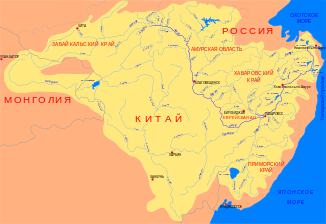
Location of the Huma He (Хумаэрхэ) in the catchment area of the Amur |
||
| Data | ||
| location | Heilongjiang ( PR China ) | |
| River system | Amur | |
| Drain over | Amur → Tatar Sound | |
| Headwaters | in the Great Hinggan Mountains 51 ° 52 ′ 18 ″ N , 122 ° 44 ′ 19 ″ E |
|
| muzzle |
Amur coordinates: 51 ° 36 '58 " N , 126 ° 40' 54" E 51 ° 36 '58 " N , 126 ° 40' 54" E
|
|
| length | 435 km | |
| Catchment area | 23,900 km² | |
| Discharge at the gauge near the mouth |
MQ |
130 m³ / s |
The Huma He ( Chinese 呼玛 河 , Russian Хумахэ, Хумаэрхэ or Кумара ) is a right tributary of the Amur ( Heilong Jiang ) in the Heilongjiang Province in the northeast of the People's Republic of China .
The Huma He rises in the Great Hinggan Mountains on the border with Inner Mongolia . The river flows through the mountains in an easterly, then in a northerly direction. Finally the Huma He makes a wide arc to the east and leaves the mountainous country. In the lower reaches of the Huma He flows in a south-southeast direction parallel to Heilong Jiang. In Huma County , about 10 km south of the large community of Huma on the Russian-Chinese border, the Huma He finally flows into the Heilong Jiang. The river is 435 km long and has a catchment area of 23,900 km². In the vicinity of the mouth, the mean discharge of the Huma He is 130 m³ / s.
The Russian fortress Kumarsk stood near the river mouth in the 17th century during the Russian-Manchurian border conflicts .
