Iba (Bebra)
|
Iba
City of Bebra
Coordinates: 50 ° 58 ′ 48 " N , 9 ° 52 ′ 20" E
|
|
|---|---|
| Height : | 266 (260–289) m above sea level NHN |
| Area : | 11.07 km² |
| Residents : | 650 (approx.) |
| Population density : | 59 inhabitants / km² |
| Incorporation : | December 31, 1971 |
| Postal code : | 36179 |
| Area code : | 06622 |
|
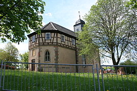
Evangelical Church in Iba
|
|
Iba is a district of the town of Bebra in the district of Hersfeld-Rotenburg in the northeast of Hesse .
The district of Iba is located east of the core town of Bebra in the valley of the Iba , a tributary of the Ulfe in the southern part of the Richelsdorf Mountains . Iba is separated from the core town by the ridge of the Mühlberg. State road 3250 runs through the village .
history
Archaeological finds show that the village was settled as early as the Bronze Age. Iba was first mentioned as Ybach in a document from 1070 . From the Middle Ages to around 1920 there was a small Jewish community in Iba that had a synagogue , a Jewish school, a ritual bath and a cemetery in the village. The cemetery is still preserved as part of the church cemetery. The synagogue is used as a residential building and is in close proximity to the church.
In 1939 the village had 759 inhabitants. At that time it belonged to the Rotenburg district . As part of the Hessian territorial and administrative reform , Iba was incorporated into the city of Bebra on December 31, 1971 .
Web links
- Districts. In: Internet presence. City of Bebra
- Iba, Hersfeld-Rotenburg district. Historical local dictionary for Hessen. In: Landesgeschichtliches Informationssystem Hessen (LAGIS).
- Literature about Iba in the Hessian Bibliography
Individual evidence
- ^ Iba, Hersfeld-Rotenburg district. Historical local dictionary for Hessen. (As of December 2, 2015). In: Landesgeschichtliches Informationssystem Hessen (LAGIS).
- ^ Federal Statistical Office (ed.): Historical municipality directory for the Federal Republic of Germany. Name, border and key number changes in municipalities, counties and administrative districts from May 27, 1970 to December 31, 1982 . W. Kohlhammer GmbH, Stuttgart / Mainz 1983, ISBN 3-17-003263-1 , p. 406 .

