Iberg (Heiligenstadt)
| Iberg | ||
|---|---|---|
|
View over Heiligenstadt to the Iberg |
||
| height | 453.2 m above sea level NHN | |
| location | near Heilbad Heiligenstadt ; Obereichsfeld , Thuringia ( Germany ) | |
| Mountains |
Heiligenstädter Stadtwald , Western Obereichsfeld |
|
| Coordinates | 51 ° 21 '55 " N , 10 ° 7' 56" E | |
|
|
||
| particularities | - Ibergwarte - Ibergrennen |
|
The Iberg is 453.2 m above sea level. NHN high mountain of the western upper area near Heilbad Heiligenstadt in the Thuringian district of Eichsfeld . It is the place of the Ibergwarte . The Ibergrennen takes place on the mountain every year .
Origin of name
The first written records can be found in the Middle Ages, for example in 1280 as the Iberc forest and in 1617 as the Iberge . The name Iberg is derived from the ahd. "Iwa" or mhd. "Iwe" for the yew trees , which used to be very common on the mountain. Since the forests were often used as forest pasture in the Middle Ages , the yew trees, which are poisonous for cattle, were cleared .
geography
location
The Iberg rises in the north of the Eichsfeld district in the Eichsfeld-Hainich-Werratal nature park , right on its northern border. Its summit is in the Obereichsfeld immediately south of Heilbad Heiligenstadt in the Heiligenstadt forest and thus on the southern edge of the Leine valley.
Natural allocation
The Iberg belongs to the natural space main unit group Thuringian Basin (with edge plates) (No. 48), in the main unit Ringgau – Hainich – Obereichsfeld – Dün – Hainleite (483) and in the subunit Westliches Obereichsfeld (483.2) to the natural area Kalteneberer step edge area (483.20) . To the north, the landscape falls into the main unit group Weser-Leine-Bergland (No. 37) and in the main unit Unteres Eichsfeld (375) into the sub-unit Eichsfelder Hügelland 375.1.
nature
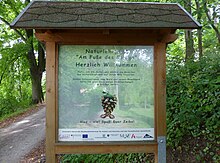
The now wooded mountain (mixed beech forest) was almost completely cut down in the 19th century and was then gradually reforested. Starting from the outskirts, the nature trail at the foot of the Iberg provides information about flora and fauna in the region, forest management, the Ibergwarte and the Eichsfeld waiting system, among other things . An avenue with the respective trees of the year is currently being laid out on the Iberg .
Worth seeing
The Iberg is an interesting hiking area, starting right on the outskirts of Heiligenstadt. There are vantage points from the Iberghaus into the Leinetal and the hill country of the middle Eichsfeld to the Göttinger Bergland, as well as from the Ibergrandweg to the western edge of the Dün . Destinations worth seeing are:
- Ibergwarte, a tower from the 13th century, on an eastern foothills of the Iberg
- Klöppelsklus, a forest chapel on the former Geleitstrasse
- Johannes Weinrich Monument
- Kurfürstenstein, with adjacent meridian stone for the 10th degree of longitude east
- Three Linden Chapel
- Recreation center Neun Brunnen at the end of the Long Valley
Ibergrennen
From 1925 to 1929, four hill climbs were held on the Iberg, which were exclusively reserved for motorcycles. In the 1970s races took place again, this time with racing cars - under the name Ibergrennen . Since 1997, the Ibergrennen races have been held every year on the last weekend in June on today's Landesstraße 2022 (see below ) , a run of the German Mountain Cup and the German Mountain Championship for touring and sports cars . The paddock is traditionally located in the streets of Heiligenstadt, which makes the Ibergrennen so special.
Route profile: length 2.05 km, difference in altitude 200 m, maximum gradient 10%, minimum gradient 8%, route width approx. 6 m, right-hand bends 7 (including 2 switchbacks ), left-hand bends 5 (including 2 switchbacks).
Traffic and walking
Coming from the direction of Heiligenstadt, the wooded Iberg can be reached via the country road 2022 (Holzweg) which branches off from the federal road 80 to the south and which leads south over the western foothills of the mountain to Heiligenstadt- Kalteneber and Bernterode , for example , and on the one section of the Frau-Holle -Route of the German Fairy Tale Route runs, can be controlled. The Unter dem Iberg nature trail, which begins southeast of Heiligenstadt, and the Ibergrandweg trail run up the mountain .
Individual evidence
- ↑ a b Map services of the Federal Agency for Nature Conservation ( information )
- ↑ Tobias Rohner: The microtoponyms of the district of Heiligenstadt. FSU Jena 2006, p. 66
- ↑ The Beginnings ( Memento of the original from May 21, 2017 in the Internet Archive ) Info: The archive link was inserted automatically and has not yet been checked. Please check the original and archive link according to the instructions and then remove this notice. , on mc-heilbad-heiligenstadt.de
- ↑ The Birth of the Ibergrennens ( Memento of the original from June 29, 2016 in the Internet Archive ) Info: The archive link was inserted automatically and has not yet been checked. Please check the original and archive link according to the instructions and then remove this notice. , on mc-heilbad-heiligenstadt.de
- ↑ The new era of the Ibergrennen ( Memento of the original from November 30, 2013 in the Internet Archive ) Info: The archive link was automatically inserted and not yet checked. Please check the original and archive link according to the instructions and then remove this notice. , on mc-heilbad-heiligenstadt.de
Web links
- Ibergrennen , on ibergrennen.de


