
Inner weather tip
| Inner weather tip | ||
|---|---|---|
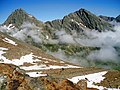
 Inner weather tip from the northeast |
||
| height | 3053 m above sea level A. | |
| location | Tyrol , Austria | |
| Mountains | Stubai Alps | |
| Dominance | 1.37 km → Outer weather tip | |
| Notch height | 292 m ↓ Lautererseejoch | |
| Coordinates | 46 ° 59 '47 " N , 11 ° 14' 47" E | |
|
||
| Normal way | East flank and north ridge ( I ) | |

The inner weather tip is 3053 m above sea level. A. high mountain in the Stubai Alps in Tyrol . It lies between the Stubai and Gschnitztal valleys, rises north above the Simmingjöchl and is separated from the somewhat higher Outer Wetterspitze ( 3,070 m ) by the Lautererseejoch . The weather peaks belonged to the Habichtkamm, a mountain ridge that branches off from the main Alpine ridge near the flintstones and runs in a north-easterly direction to the Elferspitze .
Climbs
The easiest ascent leads from the Bremer Hütte through the east flank, over the Schneekachl and the north ridge in three hours to the summit ( I ). There is also a marked trail over the east ridge up to the summit . This is partially insured, very exposed and requires climbing in grade II . This ascent variant takes two hours from the Bremer Hütte.
Inner (left) and outer weather tip from the southeast

Summit cross


Literature and map
- Walter Klier : Alpine Club Guide Stubai Alps. Bergverlag Rudolf Rother, Munich 2006, ISBN 3-7633-1271-4
- Alpine Club map sheet 31/1, 1: 25,000, Stubai Alps; Hochstubai. ISBN 3-928777-08-4
Web links
Individual evidence
- ↑ Clem Clements, Jonathan de Ferranti, Eberhard Jurgalski , Mark Trengove: The 3000 m SUMMITS of AUSTRIA - 242 peaks with at least 150 m of prominence , October 2011, p. 12.
- ↑ Federal Office for Metrology and Surveying Austria: Inner weather tip on the Austrian Map online (Austrian map 1: 50,000) .