Iraklidis
|
Iraklidis parish Δημοτική Ενότητα Ηρακλειδών (Ηρακλειδείς) |
||
|---|---|---|
|
|
||
| Basic data | ||
| State : |
|
|
| Region : |
South Aegean
|
|
| Regional District : | Kos | |
| Municipality : | Kos | |
| Geographic coordinates : | 36 ° 46 ′ N , 27 ° 2 ′ E | |
| Height above d. M .: | 0 – over 700 m Aegean – Dikeos Mountains |
|
| Area : | 160.538 km² | |
| Residents : | 6,826 (2011) | |
| Population density : | 42.5 inhabitants / km² | |
| Code No .: | 640103 | |
| Structure: |
3 boroughs |
|
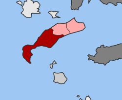
| Location in the municipality of Kos and in the regional district of Kos | ||
Iraklidis ( Greek Δημοτική Ενότητα Ηρακλειδών Dimotiki Enotita Iraklidon ) is one of three parishes of the Greek municipality and island of Kos . It emerged from the municipality of Iraklidis, founded in 1997, as part of the administrative reform in 2010 , when the former municipalities of the island were merged to form the municipality of Kos. The parish of Iraklidis is divided into three districts.
location
With 160.538 km², more than half of the island's area is in the municipality. The municipality of Dikeos borders in the east . The border runs from the south coast to the western main ridge of the Dikeos Mountains, rising steeply to heights of over 700 m and then follows its foothills reaching west. From the center of the island to the north coast, the heights are rarely more than 100 m, the Evrimos dry stream forms the natural border to the north coast. The Kefalos Peninsula in the far west rises to a maximum of 427 m.
Administrative division
The parish of Iraklides is divided into three districts with seven villages.
| Borough | Greek name | code | Area (km²) | 2001 residents | Residents 2011 | places |
|---|---|---|---|---|---|---|
| Andimachia | Δημοτική Κοινότητα Αντιμαχείας | 64010301 | 54,000 | 2573 | 2538 | Andimachia , Mastichari |
| Kardamena | Δημοτική Κοινότητα Καρδαμαίνης | 64010302 | 35,150 | 1783 | 1650 | Kardamena |
| Kefalos (Iraklidis) | Δημοτική Κοινότητα Κεφάλου | 64010303 | 71.388 | 2607 | 2638 | Kefalos , Kamari, Kambos, Onia |
| total | 640103 | 160.538 | 6963 | 6826 | ||
traffic
Kos Airport is located on the territory of the municipality south of Andimachia . The road connection from the airport east to Kos is around 23 km, to Kefalos in the west around 17 km. There are ferry connections to the neighboring islands of Nisyros and Kalymnos from the touristy coastal towns of Kardamena in the south and Mastichari in the north .
Individual evidence
- ↑ Results of the 2011 census, Greek Statistical Office (ΕΛ.ΣΤΑΤ) ( Memento from June 27, 2015 in the Internet Archive ) (Excel document, 2.6 MB)

