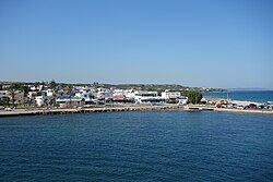
Mastichari
|
Mastichari Μαστιχάρι |
||
|---|---|---|
|
|
||
| Basic data | ||
| Country |
|
|
| region | South Aegean | |
| Regional district | Kos | |
| local community | Kos | |
| Parish | Iraklidis | |
| Borough | Andimachia | |
| Geographic coordinates | 36 ° 51 ′ N , 27 ° 5 ′ E | |
| Height above d. M. |
15 m |
|
| Residents | 470 (2011) | |
| LAU-1 code no. | 6401030102 | |
| Mastichari | ||
Mastichari ( Greek Μαστιχάρι ( n. Sg. )) Is a small place on the Greek island of Kos , which is located directly on the sea.
History, location, geography, traffic
Mastichari was founded after the severe earthquake of April 23, 1933 by some families from Andimachia who moved here to the north coast of the island. The earthquake also caused severe damage in Andimachia.
Mastichari is located around 22 kilometers west of the city of Kos at around 0 to 12 meters above sea level. Mastichari is six kilometers by road from the island's main road, which runs between Kos and Kefalos . It is about five kilometers as the crow flies to Kos Airport near Andimachia . In the south the next place is Andimachia . To the east of the village is Pyli closest to the northeast Marmari , Linopotis , Tigaki and Zipari . In the north, about ten kilometers above sea level, lies the island of Pserimos and the uninhabited island of Platy , next to it the fourth largest of the Dodecanese islands, Kalymnos .
Mastichari is connected to Kos and Kefalos and the places in between by bus lines. The islands of Kalymnos and Pserimos are approached from the port of Mastichari.
Population and political structure, economy
The seaside village of Mastichari counted since the connection of the Dodecanese to Greece in 1948 initially for rural community Andimachia ( Κοινότητα Αντιμαχείας Kinótita Andimachías ). With the territorial reform in 1997 , he came to the Andimachia municipality of the Iraklidis municipality and since the implementation of the administrative reform in 2010 to the Andimachia municipality .
- Population development of Mastichari
| year | 1947 | 1951 | 1961 | 1971 | 1981 | 1991 | 2001 | 2011 |
|---|---|---|---|---|---|---|---|---|
| Mastichari | 138 | 142 | 181 | 164 | 216 | 303 | 368 | 470 |
In the last few decades Mastichari has changed from an agriculturally oriented village or fishing village with a regionally important port to a holiday resort. In the vicinity of Mastichari, the Greek state power company DEI ( ΔΕΗ ) has been operating a 100 MW oil power plant since 1994 , which supplies the islands of Kos, Tilos , Nisyros , Kalymnos and Pserimos.
Attractions
- Very close to the sea are the ruins of an early Christian basilica with a mosaic floor that is well worth seeing.
literature
- Nikos Varelas: Kos. DumontExtra, DuMont Buchverlag Cologne 2002. ISBN 3-7701-5759-1
Web links
- Mastichari on the community website
Individual evidence
- ↑ Results of the 2011 census at the National Statistical Service of Greece (ΕΛ.ΣΤΑΤ) (Excel document, 2.6 MB)
- ↑ Madeleine Reincke, Hilke Maunder, Beate Szerelmy, Dieter Luippold: Baedeker Travel Guide Kos, Verlag Karl Baedeker, 6th edition 2013, ISBN 978-3-8297-1407-5 , p. 107.
- ↑ Κεντρική Ένωση Δήμων και Κοινοτήτων Ελλάδας (ΚΕΔΚΕ) Ελληνική Εταιρία Τοπικής Ανάπτυξης και Αυτοδιοίκησης (Ε.Ε.Τ.Α.Α.) (ed.): Λεξικό Διοικητικών Μεταβολών των Δήμων και Κοινοτήτων (1912-2001). Volume 2 (Τόμος Β, λ – ω), Athens 2002, ISBN 960-7509-47-1 , p. 98.
- ^ Population of Mastichari 1947–2011 Greek Statistical Office ELSTAT, Digital Library ; Census 2011 (Greek)
- ↑ History of the island of Kos ( Archived copy ( memento of the original from July 25, 2009 in the Internet Archive ) Info: The archive link has been inserted automatically and has not yet been checked. Please check the original and archive link according to the instructions and then remove this note. , Greek) .
- ↑ Mastichari. In: kosinfo.gr. Retrieved January 29, 2020 .

