
John Boyd Thacher State Park
|
John Boyd Thacher State Park
|
||
 |
||
| location | Albany County (New York) , USA | |
| surface | 3.41 km 2 | |
| Geographical location | 42 ° 39 ' N , 74 ° 1' W | |
|
||
| Setup date | 1914 | |
| administration | New York State | |

John Boyd Thacher State Park is a state park 15 mi (15 mi) southwest of Albany , near Voorheesville , in Albany County on Route 157 . The park extends mainly over the Helderberg Escarpment and offers a number of scenic hiking trails with panoramic views of the Green Mountains in Vermont and the Taconic Mountains of the Hudson Valley .
geography


The Helderberg Escarpment rises steeply from the Hudson Valley . It rises up to 1,100 ft (335 m) from the valley to 1,300 ft (400 m) above sea level . In the north the Waitecliff Preserve joins and about 1 km away to the west of the park is Thompson's Lake with Thompson's Lake State Park and the Emma Treadwell Thacher Nature Center (since 2001).
The park stretches along the steep drop of the Helderberg Escarpment from south to north. The Thompson's Lake sends its water to the east and the streams have cut deep into the limestone cliffs. The water pours over the Lot Falls mine to the bottom of the Hudson Valley , crossing the Indian Ladder Trail . Right next door is the Horseshoe Lot , another deep, horseshoe-shaped gorge. The streams flow east to Black Creek , which along with nearby Vly Creek flows into the Hudson River east of Voorheesville . There are around 40 caves in the park. The longest of these is Hailes Cave with 3,700 ft (1.13 km) of mapped passages and likely another 2 mi (3.2 km) of unmapped passages.
geology
The Helderberg Plateau consists of sediments from the Devonian Mountains and is one of the most fossil-rich deposits in the United States. The steep slopes open like a window into geological history. In addition to the Schenectady beds , the washed-out Waterlime ( Dolostone ) and the upper and lower Manlius , many other geological formations can be observed. At the foot of the plateau one can also find layers from the Silurian and the Upper and Middle Ordovician .
history
The history of the park begins with an old trade route, the so-called Indian Ladder Trail , which was used by the Mohawk over four hundred years ago to get to the trading post of Henry Hudson .

In 1777 Jacob Salsbury also hid from settlers in the Tory Cave during the Burgoyne invasion . The ground is very rugged. The karst limestone is not suitable for agriculture. However, there are some suitable strips of land along the rivers. Dutch settlers were lured into the area by so-called patroons , to whom they then had to pay high lease fees until they freed themselves from their debtors through the Helderberg War (Anti-Rent War) in 1839. The widow of the Mayor of Albany, Emma Treadwell Thacher, donated the land to the state in 1914 in order to establish the park in honor of her husband John Boyd Thacher . From the beginning, the area was designated as a state park . The park soon became a popular destination and many tourist facilities were built. In 2004, an additional 500 acres (2 km²) were purchased from the Environmental Protection Fund of $ 750,000 and a gift from the Nature Conservancy of 81 acres (32.7 ha), and in 2006 another 188 acres were added 0.76 km². The park now occupies a total of 2155 acres (8.72 km²).
The name of the "Helderberg Escarpment" probably goes back to the Dutch Helder (~ bright, radiant) and Berg (= mountain).
Imminent closure in 2010
Beginning of 2010, announced the governor of New York , David Paterson , that due to a massive budget deficit, many institutions would face cuts. This also included the state park. Thereupon the affected municipal administrations started a campaign together with citizens using the social networks, in which they fought for the preservation of the parks. Public pressure led to an adjustment of the plans. The park remains open.
Freetime activities
Until 2006, the park had an Olympic- sized swimming pool , volleyball fields, playgrounds, and BBQ areas, and over 12 mi (20 km) of hiking trails, including the Indian Ladder Trail .
Hiking trails
The Indian Ladder Trail is only open from May to November. All other trails are open all year round.
- Indian Ladder Trail : From the parking lot, the hiker climbs a metal ladder 60 ft (18 m) down to the base of the escarpment. From there the path follows the base of the escarpment, passing under the Minelot Falls and a stream that rises from a small cave. The water actually comes from Thompson Lake , which is approximately 2 mi (3.2 km) away. The water penetrates through the karstified limestone and comes out again at this point. At the end of the path, a second metal ladder leads the hiker back to the height of the escarpment to the parking lot. From this high path you have excellent panoramic views.

Indian Ladder Trail
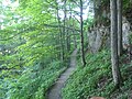
Indian Ladder Trail, path through the woods

Indian Ladder Trail, at the base of the cliffs

Indian Ladder Trail, Minelot Falls

Indian Ladder Trail, from the entrance to the stairs
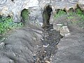
One of several cave streams in the park.


- Paint Mine Trail : The Paint Mine Trail is open all year round. In winter there may be disabilities due to snow. The trail runs for 6 mi (10 km) through wooded areas.
- The Long Path : The Long Path , developed by Vincent Schaefer of Schenectady in the 1960s, is a long-distance hiking trail . It begins at the George Washington Bridge in New York City and ends in Thacher Park, after a distance of 347.35 miles (559.01 km).
nature
The park is an important nature reserve. It is strictly forbidden to take fossils, stones, plants or animals. The use of snowmobiles in winter is also regulated.
Birds


In April 2004, Governor George Pataki announced that 1,800 acres (7.3 km²) of the park area and Thompson Lake would be designated as a bird sanctuary. The National Audubon Society had requested this step in their 1997 Important Bird Areas Program .
there are approximately 171 species of birds in the park, many of which are on the endangered species list:
- Sharp-shinned hawk (Sharp-shinned hawk - Accipiter striatus )
- Goshawk (Northern goshawk - Accipiter gentilis )
- Eagle
- Gold-winged Warbler (Golden-winged warbler - Vermivora chrysoptera )
- Cooper's Hawk (Cooper's hawk - Accipiter cooperii )
- Hermit Thrush (Hermit thrush - Catharus guttatus )
- Winter wren (winter wren - Troglodytes hiemalis )
- Blue-backed warbler (Black-throated blue warbler - Dendroica caerulescens )
- Grünwaldsänger (Black-throated green warbler - Dendroica virens )
- Stilt Warbler (Louisiana waterthrush - Seiurus motacilla ) and Riparian Warbler (Northern Waterthrush - Seiurus noveboracensis )
- Canada Warbler (Canada warbler - Wilsonia canadensis )
- Haldenwaldsänger (Worm-eating warbler - Helmitheros vermivorus )
- Common raven ( Corvus corax )
- Red-winged Blackbird (Red winged blackbird - Agelaius phoeniceus )
plants
Due to the different habitats there is a great diversity of plants. 1400 acres (5.7 km²) alone consist of Upland Forest in which mainly hardwood tree species predominate, but there are also:
- Canadian hemlock (Eastern hemlock - Tsuga canadensis )
- White Pine (Eastern white pine - Pinus strobus )
- Maples
- American linden (Basswood - Tilia americana )
- Canadian yew (Canadian yew - Taxus canadensis )
- Virginian juniper (Eastern redcedar - Juniperus virginiana )
There are also different habitats of the limestone cliffs, the Bur Black Oak Swamps , Red Maple Swamps and Emergent Marsh / Scrub Swamps .
Special shrub species and herbaceous plant species are:
- Cornus florida (Flowering dogwood - Cornus florida )
- Rock elm (rock elm - Ulmus thomasii )
- Common snowberry (Snowberry Symphoricarpos albus )
- Hairy honeysuckle ( Lonicera hirsuta )
- Clematis (Purple virgin's-bower Clematis occidentalis )
Many ferns also find ideal living conditions in the damp gorges:
- Walking fern ( Asplenium rhizophyllum )
- Purple-stemmed cliff brake ( Pellaea atropurpurea )
- Slender rock brake ( Cryptogramma stelleri )
- Brown-stalked striped fern (Maidenhair spleenwort - Asplenium trichomanes )
- Wall-rue (Wall-rue spleenwort - Asplenium ruta-muraria )
See also
Individual evidence
- ^ Geographic Names Information System . United States Geological Survey.
- ^ Page of the Washington State Parks Commission.
- ^ New York State Parks Education
- ^ US Geological Survey. National Hydrography Dataset high-resolution flowline data. The National Map .
- ↑ a b c d Winifred Goldring: Guide to the Geology of John Boyd Thacher Park. University of the State of New York, 1993, ISBN 1-55557-204-9 .
- ^ Albany City Search
- ↑ Stuberts Isle ( Memento of the original from February 3, 2013 in the web archive archive.today ) Info: The archive link was automatically inserted and not yet checked. Please check the original and archive link according to the instructions and then remove this notice.
- ↑ a b Shirin Parsavand: 1800 acre bird area preserved. In: The Daily Gazette. Schenectady, NY, April 28, 2004.
- ↑ State Governors Office press release ( Memento of the original from December 1, 2006 in the Internet Archive ) Info: The archive link was inserted automatically and has not yet been checked. Please check the original and archive link according to the instructions and then remove this notice.
- ^ New York Budget Proposals Would Close Many State Parks in 2010, End Land Acquisition. nynjtc.org New York-New Jersey Trail Conference. February 2010.
- ^ Fox news .
- ^ Paul Post: Senate Democrats say New York's state parks will stay open. In: The Saratogian. March 25, 2010.
- ↑ Weather.com - NYSPJT ( Memento of the original from May 22, 2011 in the Internet Archive ) Info: The archive link was automatically inserted and not yet checked. Please check the original and archive link according to the instructions and then remove this notice.
- ↑ The Long Path Trail ( Memento of the original from July 10, 2007 in the Internet Archive ) Info: The archive link was automatically inserted and not yet checked. Please check the original and archive link according to the instructions and then remove this notice.
- ↑ Erin Duggan: Feathered friends can nest easy at parks. In: Times Union . Albany, NY, April 28, 2004.
- ^ A b New York State Department of Environmental Conservation
- ↑ Dr HD House: Handout. New York State Museum (Botany Department) 2000.
- ↑ Purple virgins-bower ( Memento of the original from October 23, 2006 in the Internet Archive ) Info: The archive link was inserted automatically and has not yet been checked. Please check the original and archive link according to the instructions and then remove this notice.
- ↑ Walking afar
- ^ Purple stemmed cliff brake
- ↑ Slender cliff brake
literature
- KP Able: Birding New York's Hudson-Mohawk Region. Hudson-Mohawk Bird Club, Delmar, NY 1996, ISBN 0-9763649-0-5 .
- John M. Clarke: The Indian Ladder Reservation. In: Science. vol. 39, 1003, March 20, 1914, p. 418. doi: 10.1126 / science.39.1003.418
- New York State Office of Parks: Birds of John Boyd Thacher & Thompson's Lake State Parks. Albany, NY
- Bradford B. Van Driver: Roadside Geology of New York. Mountain Press Publishing Company, Missoula 1985, ISBN 0-87842-180-7 , pp. 176, 185, 208-209.