Křemelná (river)
| Křemelná | ||
|
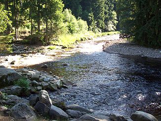
Confluence of the Křemelná (back) and Vydra |
||
| Data | ||
| Water code | CZ : 1-08-01-019 | |
| location | Czech Republic | |
| River system | Elbe | |
| Drain over | Otava → Vltava → Elbe → North Sea | |
| source | in the Šmauzy bog between Pancíř and Můstek, Bohemian Forest 49 ° 12 ′ 19 ″ N , 13 ° 15 ′ 29 ″ E |
|
| Source height | 1090 m nm | |
| confluence | with the Vydra to Otava Coordinates: 49 ° 6 ′ 35 ″ N , 13 ° 29 ′ 31 ″ E 49 ° 6 ′ 35 ″ N , 13 ° 29 ′ 31 ″ E |
|
| Mouth height | 627 m nm | |
| Height difference | 463 m | |
| Bottom slope | 15 ‰ | |
| length | 30.3 km | |
| Catchment area | 171.6 km² | |
| Drain |
MQ |
4.43 m³ / s |
The Křemelná , in sections also Zhůřský potok or Brunstský potok (German Kieslingbach , Kiesleitenbach , also Brunster Bach and Haidler Bach ) is the left source river of the Otava in the Czech Republic .
course
The Křemelná rises about six kilometers north of Železná Ruda or two kilometers north of the Pancíř (1214 m nm) in the Bohemian Forest . Its source is at the eastern foot of the Můstek (Brückelberg , 1234 m nm) near the deserted Schürerhütten in the basin between the Habr (1203 m nm) and the Jedlová (1177 m nm) in the source moor Šmauzy ( Schmausen ). The upper course of the Křemelná, which is also referred to as Brunstský potok ( Brunster Bach ), leads past the desert areas Schürerova pila ( Schürersäge ), Zadní Šmauzy ( Rear Feast Hut), Lipplova pila ( Lipplsäge ) and Přední Šmauzy ( Front Feast Hut ) in one deep boggy valley through the Pancířský hřbet ( armored ridge ) to the east. From there, following a tectonic depression , the stream flows parallel to the main Šumava ridge on the Kochánovské pláně ( Kocheter plateau ) in a wide, open valley with numerous moorland areas south-eastwards. Its upper course up to the desert of Starý Brunst ( Altbrunst ) is protected as a nature reserve "Prameniště". In Starý Brunst, the stream is crossed by the E 53 / Silnice I / 27 between Klatovy and Železná Ruda. Then the Křemelná flows into the area of the Šumava National Park ; to the left of the brook, the moorland areas were placed under protection as the "Zhůřská pláň" nature reserve in 2000 and the mountain pastures north of the Zhůří desert ( Haidl am Ahornberg ) as the "Zhůřská hnízdiště" nature reserve.
Passing the desert areas Zhůří, Horečky ( Höhal ), Malý Bor ( Haid ), Glaserwaldmühle and Šerlův Dvůr ( Schörlhof ), the stream reaches the Svojšská hornatina ( Zwoischener Bergland ). On this section, the Křemelná is initially referred to as Zhůřský potok (Haidlerbach) , from the confluence of the Slatinný potok (Filzbach) to the confluence with the Prášilský potok (Stubenbach) as Černý potok (Schwarzbach) .
The Křemelná then forms a deep valley and flows past the desolations Weberhäusel, Filzhäusel and Frantoly ( Frauenthal ). In the lower reaches of Stodůlky ( Stadln ) it takes on the character of a torrent (“Strum”) with many rapids , boulders and irregular swells in the river bed. It flows around the mountain massif of the Křemelná ( Kiesleiten , 1125 m) south in a narrow breakthrough valley and takes on the Chinitz-Tettau alluvial canal from the right . On both sides of this gorge lie the deserts of Velký Bor ( Großhaid ), Přední Paště ( Vorderwaid ), Horky u Srní ( Seckerberg ), Sedlo ( Sattelberg ) and Prostřední Paště ( Mitterwaid ). Opposite the Čeňkova pila (Vinzenzsäge) , four kilometers south of Rejštejn , the Křemelná joins the Vydra to the Otava after 30.3 kilometers .
The catchment area covers 171.6 km², the flow rate at the mouth is 4.43 m³ / s.
history
The valley of the Křemelná was from 1948 to 1991 largely in the restricted area of the military training area Dobrá Voda . The villages of Zhůří, Vysoké Lávky, Frantoly, Stodůlky and Velký Bor, which were settled in 1946 and destroyed in the following years by tank and artillery bombardments, lay on the river. Today the entire valley is completely uninhabited.
Tributaries
- Slatinný potok ( Gerlbach , Neubrunster Bach or Filzbach ; r), below the former Glaserwaldmühle
- Jezerní potok ( Seebach ; r), outflow of the Laka , above Šerlův Dvůr
- Prášilský potok ( Stubenbach or Veitbach ; r), near Šerlův Dvůr
- Mlýnský potok ( Mühlsprengbach ; r), below Stodůlky at the former Polalmühle
- Plavební potok ( Riesel / Seckerbach ; r), above Sedlo
- Chinitz-Tettauer alluvial canal (r), near Sedlo
- Paštěcký potok (l) at Paštěcký vodopád ( Waider waterfall ) near Prostřední Paště
