
Klatovy
| Klatovy | |||||
|---|---|---|---|---|---|
|
|||||
| Basic data | |||||
| State : |
|
||||
| Region : | Plzeňský kraj | ||||
| District : | Klatovy | ||||
| Area : | 8067 ha | ||||
| Geographic location : | 49 ° 24 ' N , 13 ° 17' E | ||||
| Height: | 405 m nm | ||||
| Residents : | 22,233 (Jan 1, 2019) | ||||
| Postal code : | 339 01 | ||||
| License plate : | P | ||||
| traffic | |||||
| Street: |
Pilsen - Železná Ruda Domažlice - Horažďovice |
||||
| Railway connection: |
183 Plzeň – Železná Ruda 185 Horažďovice předm. – Domažlice |
||||
| structure | |||||
| Status: | city | ||||
| Districts: | 30th | ||||
| administration | |||||
| Mayor : | Rudolf Salvetr (as of 2018) | ||||
| Address: | Náměstí Míru 62 339 01 Klatovy |
||||
| Municipality number: | 555771 | ||||
| Website : | www.klatovy.cz | ||||


Klatovy (German Klattau ) is a city in the Czech Republic . It is located 43 kilometers south of Pilsen in the Klatovy district in the Plzeňský kraj region .
geography
Geographical location
Klatovy is located on the right side of the Úhlava ( Angel ) in the Klatovská kotlina ( Klattau Basin ) and is traversed by the Drnový creek . To the north rises the Smrčí (568 m) and on the western outskirts the Klatovská hůrka ( Klattauer Berg , 498 m). Two 1st class streets cross in Klatovy; the road No I / 22. of Domažlice according Horažďovice - Strakonice - Vodňany and the road No I / 27. / E 53 of Dubí - Most - Plzen according Železná Ruda or Munich . Klatovy is on the Plzeň – Železná Ruda railway line , which is a single track to Bayerisch Eisenstein and Plattling . In the summer, rail journeys of the Ostbayern Tourist Association in Straubing with the Bohemian Forest Courier are organized through the city on this route . The route no. 185 of Domažlice via Klatovy on to Horažďovice.
City structure
The Klatovy consists of the local Beňovy ( Benhof ) Chaloupky, Čínov ( re Come ) Dehtín ( Dechtin ), Dobrá Voda ( Gutwasser ) Drslavice ( Derslawitz ) Habartice ( Habartitz ), cal ( Gall ), Klatovy I, Klatovy II , Klatovy III, Klatovy IV, Klatovy V, Kosmáčov ( Kosmatschow ), Křištín ( Krischtin ), Kvaslice ( Kwaslitz ), Kydliny ( Kidlin ), Lažánky ( Laschanek ), Luby ( Lub ), Otín ( Wottin ), Pihovice ( Pihowitz ) Sobětice ( Sobietitz ) Štěpánovice ( Stiepanowitz ) Střeziměř ( Stresmersch ) Tajanov ( Tajanow ) Tocnik ( Totschnik ) Tupadly ( Tupadl ) Věckovice ( Wetzkowitz ) Vícenice ( Witzenitz ) and Vítkovice ( Witkowitz ). Basic settlement units are Beňovy, Bor, Chaloupky, Čínov, Dehtín, Dobrá Voda, Domažlické předměstí, Drslavice, Habartice, Husovo náměstí, K Čertovce, K Čínovu, K Točníku, K Zaječímu-Klickéchu, K Zaječímu-Klickéchu, K Zaječímu-histor, Klickatro jády II, Kosmáčov, Křištín, Kvaslice, Kydliny, Lažánky, Luby, Na Harfě, Na Klášterce, Na rozvoji, Nad nádražím, Nad rybníčky, Obchodní zóna, Otín, Pátátá čtvrť, Podhovice, Čtvr Bor, Pihovice věží, Pod Hůrkou, Pod muzeem, Pod parkánem, Pod vodojemem, Sídliště Plánická, Sobětice, Štěpánovice, Střeziměř, Tajanov, Točník, Tupadly, U hřbitova, U nemocnice, U hřbitova, U nemocnice .
The urban area is divided into the cadastral districts of Dehtín, Drslavice u Tupadel, Habartice u Obytců, Kal u Klatov, Klatovy, Kosmáčov, Křištín, Kvaslice, Kydliny, Luby, Otín u Točníku, Třanovice u Klatov, Sobětice u Klatov , Točník u Klatov, Tupadly u Klatov, Věckovice u Janovic nad Úhlavou and Vícenice u Klatov.
Neighboring communities
Neighboring towns are Malá Strana, Sekrýt, Třešňovka, Štěpánovice, Markyta and Točník in the north, Chaloupky, Čertovka, Ostřetice and Pihovice in the north-east, Slavošovice, Cinovec, Čínov and Kydliny in the east, Hoštičobky, Lažrovánky in the east, Hoštičobky, Lažrovánky in the east, Hoštičobky, Lažrovánky in the south Luby in the south, Lomec , Lomecká hospoda, Novákovice, Na Hrázi, Volenov, Drážský Mlýn and Bezděkov in the south-west, Beňovy, Kal and Tajanov in the west and Dupanda, Andělice and Svrčovec in the north-west.
history

Klatovy was founded by the late 13th century at an important crossroads, the parallel to the Šumava ridge West Bohemia and South Bohemia from Cheb through the territory of Chods to České Budějovice led and Deggendorf has connected to Pilsen.
Klatovy was built as a successor to an older settlement on this trade route between Bohemia and Bavaria with a chessboard-like floor plan and enclosed with an oval fortification belt, parts of which are still preserved today. Between 1260 and 1263, the place was raised under Ottokar II Přemysl to the royal city . Since 1419 Klatovy was an important seat of the Hussites , under whom - despite a city fire in 1464 - the economic development of the privileged city continued. Lively building activity brought the Renaissance to Klatovy among Italian architects .
In 1620 the city was occupied by Imperial Catholic troops. The Thirty Years War led to city fires, looting, rape and cultural decline. In 1636, at the time of the re-Catholicization of Bohemia, the order of the Jesuits settled in Klatovy. These contributed significantly to the reconstruction and economic development of the city in the following years. The city's buildings in the Baroque style date back to this time. During his stay at the Jesuit convent in Klattau, the historian Bohuslav Balbín wrote his famous defense of the Czech language.
In the middle of the 18th century the city became a district town in Bohemia within the Habsburg Monarchy , since 1804 the Austrian Empire . New branches of industry emerged; for example, was in 1813 with clove seeds from Nancy a carnation breeding in Klatovy founded. In the 19th century the cityscape changed again; some buildings were changed under the influence of the imperial court in Vienna in the style of classicism , the city fortifications partially removed and the trenches filled in. After the abolition of patrimonial Klatovy / Klattau formed a municipality in the judicial district of Klattau from 1850 and became the seat of a district court. From 1868 the city was the seat of the Klattau district . In 1876 the railway line to Pilsen was opened. In the second half of the 19th century, as part of the national rebirth of the Czechs, Czech lessons at the Klatovy grammar school began, replacing classes in Latin.
During National Socialism, the city belonged to the Protectorate of Bohemia and Moravia . On May 5, 1945, one of the last days of World War II, the city was briefly occupied by the Third United States Army under General George S. Patton via Cham (Upper Palatinate) , coming from Regensburg. This advance to the Karlovy Vary-Pilsen-Budweis line was the easternmost advance of the US troops into Czechoslovakia . Russian-Soviet and Czech troops took over the area, which until 1993 was in the area of the border fortifications of Czechoslovakia during the Cold War . German-speaking citizens of the city and its surroundings tried to reach the reception camp in Furth im Wald during the expulsion of the Germans from Czechoslovakia .
With the beginning of tourism and the opening of the borders after the end of communism , the old town of Klatovy was placed under monument protection in 1992, numerous buildings were restored, new shops, service providers, cafes and restaurants as well as cultural institutions were established.
Town twinning
- Cham , Germany, since 1993
- Heemskerk , Netherlands, since 1997
- Polevskoi , Russia, since 2010
- Poligny , France, since 1992
Culture and sights
Museums
- The former baroque Dominican monastery church of St. Laurentius, built 1694–1709 by Marc Antonio Gilmetti and a church until 1785, was profaned , like the associated monastery buildings, by the Josephine reforms . The interior of the church, which is now used as an exhibition building and concert hall, was lost. Educational and cultural institutions are housed in the buildings.
- The former baroque pharmacy at the White Unicorn ( U Bílého jednorožce ) - operated from 1776 to 1966 - was renovated and is currently a museum. This consists of the sales room ( Offizin ) with furniture and sculptures from the 18th century and a workshop with a work table and instruments. On the basis of the historical facility with ointment and powder jars, mortars, medicines, herbs and chemical substances, healing treatments of the past - for example bloodletting in front of a vessel with living leeches - are explained in the course of guided tours .
- Another museum - the Dr. Karel Hostaš Folklore Museum - is housed in an Art Nouveau building from 1905–1907 outside the former city walls. It documents the individual epochs in the history of the town of Klatovy.
Buildings
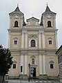
- The Church of the Immaculate Conception of the Blessed Virgin Mary and Saint Ignatius ( Czech Kostel Neposkvrněného početí Panny Marie a svatého Ignáce ) by Carlo Lurago and Giovanni Domenico Orsi de Orsini was built by the Order of the Jesuits from 1655 to 1659 . The richly decorated baroque portals were created in Kilian Ignaz Dienzenhofer's workshop . There is an extensive crypt under the church. Due to special ventilation conditions in the catacombs , the bodies of the 37 members of the Jesuit order buried there and numerous members of noble families in South Bohemia were naturally mummified and have thus been preserved. The associated college buildings were profaned after the repeal of the Jesuit order in 1773 through Josephine reforms . After changing uses, the complex now houses u. a. the city library.
- The town hall was a renaissance building begun in 1557, which was changed several times after the town fires. The current shape with sculptures and facade paintings was created in the 1920s by Josef Fanta . The town hall is dominated by the 81.6 m high dark gray quarry stone tower Black Tower , to which Antonio de Salle is attributed. 226 steps lead to a platform that offers a view of the Bohemian Forest .
- To the east of the market square is the parish church of the Birth of Mary of the Archdechanate of Klattau, the building, which originally dates back to the 13th century and the founding of the town, has been rebuilt several times and has become a monument to the Gothic period . The church houses a miraculous image of Mary, the Klattau Madonna , which has been the destination of numerous pilgrimages since 1684. The white bell tower next to the church - built in 1581 and raised in 1758 - is called the White Tower ; its portal was once used in the church.
- Remains of the city fortifications from the 14th century with two preserved round towers that separate the old town and new town. In the center of the old town is the square market square, where the town hall with its black tower ( Černá věž in Czech ), the baroque double tower facade of the Jesuit church and some renovated town houses impressively show the art-historical development of the city. This tallest tower in the city survived all the major fires of 1579, 1615, 1700, 1758. The citizen of Klattau, Master Anton, had it built from rubble stone as a watchtower in 1547–1557. The tower was changed in 1872 in the Gothic style , based on the model of the towers of the Tyn Church in Prague, in the style of the time.
Green spaces and recreation
Klatovy has a number of parks and green spaces both inside and outside the city walls.
- The oldest and at the same time largest complex (115,000 m²) is the Mercandin city park in the style of an English landscape garden with historical trees, supplemented by a French garden in the Empire style with colonnade, fountains and sculptures. Within the park, the Drnový brook flows through a natural lake that existed before the park was established in the years 1841–1845. The park is located in the triangle between the arterial roads to Strakonice and Železná Ruda. Named he is under an Austrian administrative officials, the District Chief in Klattau Franz Xaver Graf Mercantin
- In the east of the new town lies the park at the waterworks named after the reformer Jan Hus (20,000 m², laid out in 1904). A lookout tower was planned, but was not realized.
- Several green spaces border the old town in front of the - largely demolished - city wall. The oldest of these parks on the ramparts was built in 1889 on an area of 6880 m² south of the Archdean Church and the former Dominican monastery . There is also a round tower of the city fortifications, a monument to the geologist Jan Krejčí and a pyramid-shaped sculpture by Václav Fiala. This part is named after the poet and translator Jaroslav Vrchlický . To the north of it, the park was expanded in 1934 in place of the trenches filled in between the city walls (named after the mayor and museum founder Karel Hostaš ). Parts of the city fortifications - a bastion and a semicircular tower - have also been preserved here. In the western park by the ramparts below the Black Tower, nothing of the city wall has survived. This section was created in 1903; a baroque torture column from 1643 with the saints Wenceslas and Adalbert originally stood on Nepomuk Street.
- Smaller additional green areas were created in the 21st century (at the White Tower in 2001, at the former Jesuit college - today the city library - in 2005).

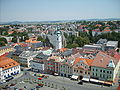
Market square with Jesuit church and Black Tower
Old town with the White Tower (seen from the Black Tower)

Baroque pharmacy "To the white unicorn"
Former Dominican church

City park by the ramparts with a monument to Jan Krejčí
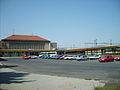
railway station


traffic

The town is located at the intersection of the railway line (Praha -) Plzeň - Železná Ruda-Alžbětín with the branch lines Domažlice - Klatovy - Horažďovice předměstí. This is where the train station is located to the northwest of the center. Another stop is at Klatovy-město south of the center on the route towards Horažďovice.
There are three bus routes (1, 2 and 4) operated by the ČSAD-Plzeň company in the city.
Personalities
sons and daughters of the town
- Václav Matěj Kramérius (1759–1808), writer and publisher
- Karel Slavoj Amerling (1807-1884), educator and philosopher
- Ottokar Josef von Prochazka (1811–1885), officer, 1873 Lieutenant Field Marshal
- Franz Kiwisch von Rotterau (1814-1852), gynecologist
- Augustin Krejci (1857–1918), classical philologist (University of Graz), high school teacher (1880 in Pisek, 1884 in Neubydzow, since 1900 in Prague)
- Jan Krejčí (1825–1887), geologist and mineralogist
- August Breisky (1832-1889), gynecologist
- Jan Ludvik Prochazka (1837–1888), music critic and composer
- Josef Klička (1855–1937), composer, organist, conductor and music teacher
- Lubor Niederle (1865–1944), archaeologist and ethnographer
- Adalbert Suchy (Czech Vojtěch Suchý) (1783–1849), miniature painter, father of the Viennese painter Maria Antonia Sucha
- Bohumil Markalous (1882–1952), writer, journalist, university professor, art esthete and critic
- Pavel Dobrý (* 1976), football player
- Petr Frydrych (* 1988), javelin thrower
Lived and worked in the place
- Bohuslav Balbín (1621–1688), Bohemian Jesuit, historian and geographer
- Vladimír Boublík , Czech theological philosopher
- Jan Čapek , Bohemian writer and clergyman
- Ignác Cornova , Italian priest, historian, educator and poet
- Josef Dobrovský , Czech philologist and Slavist, founder of the modern written Czech language
- Josef Hlávka , Czech builder, architect and patron
- Martin Lupáč , Czech theologian and diplomat of the Hussites
- Rudolf Mayer , Czech poet and writer
- Leopold Eugen Měchura , composer
literature
- Johanna von Herzogenberg : Between Danube and Moldau. Bavarian Forest and Bohemian Forest. The Mühlviertel and South Bohemia. Prestel, Munich 1968, p. 103 f.
Web links
- Homepage (Czech, German, English)
- Catacomb mummies from Klatovy / Klattau in a new look on Radio Praha from April 1, 2011
Individual evidence
- ↑ Český statistický úřad - The population of the Czech municipalities as of January 1, 2019 (PDF; 7.4 MiB)
- ↑ http://www.uir.cz/casti-obce-obec/555771/Obec-Klatovy
- ↑ http://www.uir.cz/zsj-obec/555771/Obec-Klatovy
- ↑ http://www.uir.cz/katastralni-uzemi-obec/555771/Obec-Klatovy
- ↑ http://www.klatovy.cz/mukt/fr.asp?tab=mukt&id=4353&burl=&pt=PM
- ↑ http://www.klatovy.cz/mukt/fr.asp?tab=mukt&id=4350&burl=&pt=PM
- ↑ http://www.klatovy.cz/mukt/fr.asp?tab=mukt&id=4354&burl=&pt=PM
- ↑ http://www.klatovy.cz/mukt/fr.asp?tab=mukt&id=4355&burl=&pt=PM
- ↑ (Karl M. Swoboda: (Ed.) Barock in Böhmen, Prestel-Verlag Munich, 1964, page 317, design of the facade of the Jesuit Church in Klattau Fig. 11)