Rejštejn
| Rejštejn | ||||
|---|---|---|---|---|
|
||||
| Basic data | ||||
| State : |
|
|||
| Region : | Plzeňský kraj | |||
| District : | Klatovy | |||
| Area : | 3,043,688 ha | |||
| Geographic location : | 49 ° 8 ' N , 13 ° 31' E | |||
| Height: | 568 m nm | |||
| Residents : | 255 (Jan. 1, 2019) | |||
| Postal code : | 341 92 - 342 01 | |||
| License plate : | P | |||
| traffic | ||||
| Street: | Sušice - Horní Vltavice | |||
| structure | ||||
| Status: | city | |||
| Districts: | 9 | |||
| administration | ||||
| Mayor : | Horst Hasenöhrl (as of 2014) | |||
| Address: | Náměstí Svobody 1 341 92 Kašperské Hory |
|||
| Municipality number: | 557021 | |||
| Website : | www.sumavanet.cz/rejstejn | |||
Rejštejn (German Unterreichenstein ) is a city in the Czech Republic . It is located 31 kilometers southwest of Strakonice and belongs to the Okres Klatovy . With around 250 inhabitants, it is the fifth smallest city in the Czech Republic.
geography
Rejštejn is located at the confluence of the Losenice ( Losnitz ) in the Otava ( Wottawa ) in the Bohemian Forest . North rises the Borovina (729 m) in the East Vinice (812 m) south of the Rejštejn (848 m) with the rock Maierová skála ( Maier Stone ), in the southwest of Radkovský vrch ( Rogauer mountain , 907 m) and northwest of the Nad Klášterským mlýnem (731 m). The city lies on the edge of the Šumava Protected Landscape Area . State road II / 169 between Sušice and Horní Vltavice runs through Rejštejn .
Neighboring towns are Radešov ( Schröbersdorf ) and Opolenec ( Oppelitz ) in the north, Tuškov ( Duschowitz ) in the northeast, Kašperské Hory ( Bergreichenstein ) in the east, U Gabriela ( Beim Gabriel ) and Lídlovy Dvory ( Liedlhöfen ) in the southeast, Malý Kozí Hřbet ( Klein Ziegenruck ), Velký Kozí Hřbet ( Groß Ziegenruck ) and Svojše ( Zwoischen ) in the south, Velký Babylon ( Groß Babylon ) in the southwest, Klášterský Mlýn ( Klostermühle ), Malý Radkov ( Ragersdorf ) and Velký Radkov ( Rogau ) in the west and Vatětice ( Watetitz ) in the north-west.
history
Reichenstein emerged in the 13th century as a settlement for miners and gold seifers after gold deposits had been discovered in the area. The first written mention comes from the year 1337. At this time the gold mining was already in full bloom. According to Kaspar Maria von Sternberg , over 300 quick and gold mills are said to have been in operation; The rich mountain settlement is said to have supported King John of Luxembourg with 600 men in a campaign against the Landshut fortress . In 1345, Johann von Luxemburg elevated the Reichenstein settlement to a mining town and granted it duty and toll exemption as well as a coat of arms showing an arm with a hammer and two mountain irons; today this forms the coat of arms of Rejštejn. Even before 1345 the mountain settlement was owned by the villages of Haidl ( Zhůří ) and Innergefild and held shares in Nezditz , Ostružno , Pohorsko and Mitsch ( Damíč ). Between 1360 and 1365 Charles IV had the royal castle Karlsberg built north of the town and in 1366 the Goldener Steig took a new route via Reichenstein to Passau and the Salzkammergut . In the 15th century, 40 mines were in operation, and mining continued to take place only at a shallow depth. Up until the 16th century, Reichenstein was considered a town whose center was on the saddle. In 1572, King Maximilian II gave the town of Bergreichenstein a new coat of arms. In 1584 King Rudolf II raised Bergreichenstein and Unterreichenstein to royal mining towns and sold the rule of Karlsberg to the town of Bergreichenstein. This finally made a distinction between two cities, with Unterreichenstein always standing in the shadow of its larger sister city Bergreichenstein. Due to the Thirty Years War and the exhaustion of the deposits, mining came to a complete standstill in the 17th century. Glassmaking found its way into the new livelihood. Initially, glass beads and then sheet glass were produced. In Klostermühle, Jean Baptist Eisner von Eisenstein founded a crystal glassworks in 1836 , which later traded as Joh. Loetz Witwe and which became famous overseas in particular for its iris glass .
In 1838 the royal mountain town of Unterreichenstein comprised a usable area of 619 yoke 287 square fathoms . Their territory was limited exclusively to the city, there were no subordinate villages. The gold mining town of Unterreichenstein or Rechssteyn consisted of 68 houses with 537 inhabitants. The parish church of St. Bartholomew and the school were under the patronage of the kk Berg-Aerars. There was also a town hall, a brewery, two bourgeois mills with board saws and an emphyteutic mill in Unterreichenstein . The city judge was the highest organ in the city. The inhabitants of the city lived from cattle breeding, agriculture and spinning; there were also 21 businesses. Unterreichenstein had the privilege of holding four annual markets; only one was held, which was insignificant with seven foreign traders. Unterreichenstein was the parish for the villages of Haidl, Zwoischen, Groß-Ziegenruck, Klein-Ziegenruck, Flußhaus ( Flusárna ), Klostermühl, Vorder-Waid ( Přední Paště ), Middle-Waid ( Prostřední Paště ), Hinter-Waid ( Zadní Paště ), Ebenwies ( Lužná ), Holzschlag ( Paseka ) and Wunderbach as well as the Pilsenhof houses to the left of Losnitz. Until the middle of the 19th century, Unterreichenstein was a free royal mountain town.
After the abolition of patrimonial formed under Reichenstein / Dolni Reichenstein 1850 with the hamlet Klostermühl / Klášterský Mlýn a town in the district court Bergreichenstein. From 1868, Unterreichenstein belonged to the Schüttenhofen district . In 1878, the carpenter and businessman Franz Watzlawick from Bergreichenstein acquired a wood turning shop in the lower Losnitz valley on the land border with Bergreichenstein, which he initially expanded under the name of First Austro-Hungarian stroller wheel factory Franz Watzlawick and later renamed Bohemia Werke Bergreichenstein. As a Czech place name was the end of the 19th century Dolní Reichenštein and at the beginning of the 20th century Dolní Rejštein used. The current place name Rejštejn was introduced in 1924. In 1930 Unterreichenstein had 1,021 inhabitants. The Bohemia works were during the Great Depression to one of the largest wood processing companies in Sumava consolidate and acquisitions still employees of the defunct glassworks in Klostermühle; the multiple efforts to establish a railway connection were unsuccessful. In the 1930s the company, which also had a sawmill in Ferchenhaid , had 230–250 employees. After the Munich Agreement , Unterreichenstein was added to the German Empire. From 1939 to 1945 the city belonged to the Bavarian district of Bergreichenstein . In 1939 there were 1006 people living in Unterreichenstein. During the Second World War, a large part of the workforce at Bohemia Werke was drafted into the Wehrmacht . The production switched to ammunition boxes was only maintained through the use of prisoners of war and forced labor.
After the Second World War, the city was assigned to Czechoslovakia. The Bohemia Werke, which at that time only had 37 employees, were nationalized. Most of the German-speaking residents were expelled . Her property confiscated by Beneš Decree No. 108 and the Catholic Churches in Czechoslovakia expropriated . The state administrator of the Bohemia Werke tried to delay this and to keep the specialists, because he feared that the new settlers would not do justice to the difficult working conditions and the situation as commuters . Eventually the production of baby carriages was stopped and the factory was converted into an assembly workshop for kitchen furniture; Later it was used as a factory by the Solo company . In 1947 the glassworks in Klášterský Mlýn stopped production. In the same year Radešov was incorporated. 1954 Rejštejn lost together with Strážov and Nalžovské Hory the city rights. In the course of the abolition of the Okres Sušice, Rejštejn was assigned to the Okres Klatovy in 1960. In 1961 Kozí Hřbet was incorporated (with Buchingrův Dvůr, Čenkova píla, Jelenov, Malý Kozí Hřbet, Plzenec, Svojše and Velký Kozí Hřbet). At the same time Velký Radkov from Vatětice and Zhůří from Horská Kvilda to Rejštejn were umgemeindet. Rejštejn has been a city again since October 23, 2007.
Local division
The town of Rejštejn consists of the districts Jelenov ( Hirschenstein ), Klášterský Mlýn ( monastery mill ), Malý Kozí Hřbet ( Klein Ziegenruck ), Radešov ( Schröbersdorf ), Rejštejn ( Unterreichenstein ), Svojše ( Zwoischen ), Velbetký Kozí Hřbet ( Great Ziegen ) Radkov ( Rogau ) and Zhůří ( Haidl ). Basic settlement units are Klášterský Mlýn, Klášterský Mlýn II, Kozí Hřbet ( Ziegenruck ), Radešov, Rejštejn, Svojše, Velký Radkov, Velký Radkov II and Zhůří. Rejštejn also includes the layers Buchingrův Dvůr ( Buchingerhof ), Čeňkova Pila ( Vinzenzsäge ), Dobronín ( Nimpfergut ), Luha, Turnerova chata ( Turnerhütte ), U Gabriela ( Gabrielhof ) and Vysoká Myť ( Hochreit ).
The municipality is divided into the cadastral districts Klášterský Mlýn I, Klášterský Mlýn II, Kozí Hřbet, Radešov u Rejštejna, Rejštejn, Svojše, Velký Radkov I, Velký Radkov II and Zhůří u Rejštejna.
In the corridors of the community that are deserted villages Bacher, Bystrá ( Wunderbach ), elephants mill Kramlův Mlyn, Plzenec ( Pilsenhof ) Moosbauer, Myší Domky ( Maushäusel ) Stim Ling ( voice Ling ) Hluboká ( Tiefenthal ) and Václavíková pila ( Watzlawickfabrik ).
Attractions
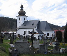
- Church of St. Bartholomew, built in 1570 and rebuilt in 1792. The grave sites of the glass manufacturers Loetz, Spaun, Procházka and Alferi as well as Charlotte Klostermann, the mother of Karel Klostermann and his brother Jakub are located in the adjacent cemetery .
- Villa of the glass manufacturer Maximilian von Spaun in Klášterský Mlýn, Art Nouveau building based on a design by the Viennese architect Leopold Bauer
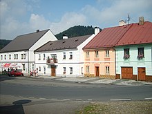
- Fountain in the market
- Stone block with indentations from the time of medieval gold mining, on the market
- Maierová skála viewpoint, south of the city
- Waldkapelle Klapperle, north of the city
Web links
Individual evidence
- ↑ http://www.uir.cz/obec/557021/Rejstejn
- ↑ Český statistický úřad - The population of the Czech municipalities as of January 1, 2019 (PDF; 7.4 MiB)
- ↑ Kaspar Sternberg : Outlines of a History of the Bohemian Mines. Volume 1, Department 1. Haase Sons, Prague 1836, p. 250 .
- ↑ Johann Gottfried Sommer : The Kingdom of Bohemia. Volume 8: Prachiner Circle. Calve, Prague 1840, pp. 262-264 .
- ^ Michael Rademacher: German administrative history from the unification of the empire in 1871 to the reunification in 1990. Landkreis Bergreichen (Czech. Kasperské Hory). (Online material for the dissertation, Osnabrück 2006).
- ^ Alfred Schickel : The expulsion of the Germans. History, background, reviews. 2nd, expanded edition. MUT, Asendorf 1987, ISBN 3-89182-014-3 .
- ↑ http://www.uir.cz/casti-obce-obec/557021/Obec-Rejstejn
- ↑ http://www.uir.cz/zsj-obec/557021/Obec-Rejstejn
- ↑ http://www.uir.cz/katastralni-uzemi-obec/557021/Obec-Rejstejn


