Pohorsko
| Pohorsko | ||||
|---|---|---|---|---|
|
||||
| Basic data | ||||
| State : |
|
|||
| Region : | Plzeňský kraj | |||
| District : | Klatovy | |||
| Municipality : | Nezdice na Šumavě | |||
| Area : | 197.8219 ha | |||
| Geographic location : | 49 ° 10 ' N , 13 ° 38' E | |||
| Height: | 746 m nm | |||
| Residents : | 71 (March 1, 2001) | |||
| Postal code : | 342 01 | |||
| License plate : | P | |||
| traffic | ||||
| Street: | Nezdice na Šumavě - Pohorsko | |||
Pohorsko (German 1939–45: Buchholz ) is a district of the municipality of Nezdice na Šumavě in the Czech Republic . It is located six kilometers northeast of Kašperské Hory and belongs to the Okres Klatovy .
geography
Pohorsko is located on a hill between the valleys of the Nezdický potok and Zuklínský potok in the foothills of the Bohemian Forest in the area of the Kašperská vrchovina Nature Park. To the southeast rises the Javorník ( Jawornik , 1066 m), in the south the Královský kámen ( Königsstein , 1058 m) and southwest of the Svatý Jan (1047 m) and the Ždánov ( Zosumberg , 1064 m).
Neighboring towns are Nezdice na Šumavě , Hamr, Lazny and Strašín in the north, Nahořánky, Hrbeček, V Aleji, Maleč and U Studničky in the northeast, Na Bludné and Zuklín in the east, Podzuklín, Milíkov, Lhota nad Rohanovem and Zavorník in the southeast, Tejmlov, , Chalupy, Šebestov and Nicov in the south, Řetenice , Ždánov , Záluží, Cikánka, Kašperské Hory and Kavrlík in the south-west, České Domky, Žlíbek and Kukanda in the west and Klepačka, Ostružno , Pazderna and Papírna in the north-west.
history
Pohorsko was first mentioned in a document in 1396, but the village is much older. It was probably created in the course of the inland colonization as a border village on the edge of the uninhabited border forest. Even before Reichenstein was elevated to the status of a royal mountain town in 1345, parts of Nezdice, Ostružno and Pohorsko belonged to the mountain settlement. Between 1522 and 1523 a part of Pohorsko belonged to the family property of the Švihovský von Riesenberg , this part was connected with the Žichovice manor . Another part of the village was subject to the Zuklín estate and was later attached to the Hoschtitz cameraman . In 1788 Pohorsko including Zalužy ( Záluží ) consisted of 27 houses, which were divided between the lords of Schichowitz , Hoschitz and the town of Bergreichenstein.
In 1838 Pohorsko , also called Buchholz , consisted of 27 houses with 177 Czech-speaking residents. Of these, 12 houses belonged to the Schichowitz estate, eight houses with 40 inhabitants, including the mill in Záluží belonging to the Bergreichenstein estate and another seven houses to the Cuklin estate, which was united with the Strahl-Hoschtitz estate. There was an inn in the village. The one-layer Zalužj ( Záluží ), consisting of a hunter's house, a farmyard , a chalet and a mill with a board saw, lay apart . The parish was Strashin . Until the middle of the 19th century, Pohorsko was always divided between the Fideikommissherrschaft Schichowitz, the Herrschaft Strahl-Hoschtitz and the Dominium Bergreichenstein.
After the abolition of patrimonial Pohorsko formed from 1850 a district of the Strašín municipality in the judicial district of Schüttenhofen. From 1868 the village belonged to the district of Schüttenhofen . In 1890 Pohorsko broke away from Strašín and formed its own community. In the course of the abolition of the Okres Sušice, Pohorsko was assigned to the Okres Klatovy in 1960. In 1961 it was incorporated into Nezdice .
In 1991 Pohorsko had 83 inhabitants. In 2001 the place consisted of 46 houses in which 71 people lived. In total, Pohorsko consists of 74 houses.
Local division
The district of Pohorsko forms a cadastral district. The Záluží ( Zalusch ) single-layer belongs to Pohorsko .
Attractions
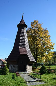
- Chapel of St. Prokop, consecrated in 2001
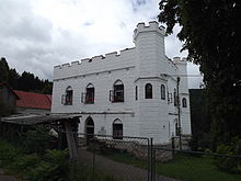
- Hunting lodge Záluží, it was built in 1860 for the owner of the Žichovice estate, Gustav von Lamberg, and was owned by the von Lamberg family until 1946. After the expropriation, the castle was used by the state forest as a forest office and forester's house, and later as a keeper's house . In 1997 it was privatized. Since a renovation, it has been used as a holiday apartment and riding stables.
- Fallen memorial
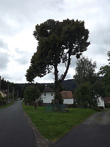
- Natural monument Pohorsko with occurrence of the Bohemian gentian , at the southwest exit of the village
Web links
Individual evidence
- ↑ http://www.uir.cz/katastralni-uzemi/704431/Pohorsko
- ↑ Jaroslaus Schaller : Topography of the Kingdom of Bohemia. Part 3: Prachiner Circle. Schönfeld, Prague et al. 1790, p. 160 .
- ↑ Johann Gottfried Sommer : The Kingdom of Bohemia. Volume 8: Prachiner Circle. Calve, Prague 1840, pp. 190 , 272 .
- ↑ http://www.czso.cz/csu/2009edicniplan.nsf/t/010028D080/$File/13810901.pdf
- ↑ http://www.uir.cz/adresy-objekty-casti-obce/104434/Cast-obce-Pohorsko
- ^ Website of the Záluží hunting lodge


