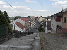
Plánice
| Plánice | ||||
|---|---|---|---|---|
|
||||
| Basic data | ||||
| State : |
|
|||
| Region : | Plzeňský kraj | |||
| District : | Klatovy | |||
| Area : | 5562.0443 ha | |||
| Geographic location : | 49 ° 23 ' N , 13 ° 28' E | |||
| Height: | 579 m nm | |||
| Residents : | 1,653 (Jan 1, 2019) | |||
| Postal code : | 339 01 - 341 42 | |||
| License plate : | P | |||
| traffic | ||||
| Street: | Klatovy - Zborovy | |||
| structure | ||||
| Status: | city | |||
| Districts: | 12 | |||
| administration | ||||
| Mayor : | Zdeněk Pavlíček (as of 2014) | |||
| Address: | Náměstí ing. Křižíka 180 340 34 Plánice |
|||
| Municipality number: | 556955 | |||
| Website : | www.planice.cz | |||
Plánice (German Planitz ) is a city in the Czech Republic . It is located 13 kilometers east of Klatovy and belongs to the Okres Klatovy .
geography
Plánice is located on the left side above the valley of the Úslava on the edge of the nature park Plánický hřeben ( Planitz ridge ) in the Nepomucká vrchovina ( Nepomuker Bergland ). In Plánice, the state road II / 187 between Nepomuk and Sušice crosses with the II / 186 from Klatovy to Zborovy .
Neighboring towns are Újezd u Plánice and Kratice in the north, Kvasetice in the north-east, Zborovy in the east, Plichtice in the south-east, Hnačov in the south, Nová Plánice in the south-west, Vracov and Kvaslice in the west and Vítkovice in the north-west.
history
The first mention of the place took place in 1144 in connection with the establishment of the Cistercian monastery Pomuk . After the destruction of the monastery by the Hussites , Plánice became the seat of a secular rule whose owners included the lords of Schwanberg , von Sternberg , Lev von Rosental and Martinic . At the beginning of the 18th century, Adolf Bernhard Graf Martinic commissioned the builder Kilian Ignaz Dientzenhofer to build a basilica on the hill of Nicov, two kilometers south-east of the city. After he had acquired the rule Grünberg in 1726 , he joined Planitz to this rule. In 1790 the Counts of Valais acquired the rule. It included to 1850 the town Planitz and the villages Vracov, Kvasetice, Kratice, Němčice, Újezd , Mlynářovice, Myslív , Zbyslav, Mlýnské Struhadlo , Neurazy , Bližanovy, Vojovice, Klikařov, Maňovice , Kramolín , Polánka , Novy Dvur, Kovčín , Milčice , Loužná, Nehodiv , Štipoklasy, Chlum , Zborovy , Hnačov , Lovčice, Pohoří, Skránčice, Plánička, Křížovice and Nicov. At that time, 7149 people lived on the domain.
After the abolition of patrimonial , Planice / Planitz became the seat of a district court and from 1850 formed a municipality in the judicial district of Planitz with the districts of Nicov and Nová Plánice. From 1868 Planice belonged to the Klattau district . The name form Plánice has been used since the end of the 19th century . In 1960, Hnačov was incorporated , in 1975 by Zbyslav (with Stuchlovna) and in 1976 by Újezd u Plánice (with Mlynářovice and Mlýnské Struhadlo ). 1980 still Číhaň (with Křížovice, Vracov and Zdebořice) and Lovčice (with Bližanovy, Kvasetice, Pohoří, Štipoklasy) were incorporated. Some of the incorporated places broke away after the Velvet Revolution.
Community structure
The town Plánice consists of the districts Bližanovy ( Blisanow ) Křížovice ( Krischwitz ) Kvasetice ( Kwasetitz ) Lovčice (, Lowtschitz ) Mlynářovice ( Mlinarschowitz ) Nová Plánice ( Neuplanitz ) Plánice ( Planitz ) Pohoří ( Pohorsch ) Štipoklasy ( Stipoklas ), Vracov ( Wratzow ), Zbyslav ( Sbislaw ) and Zdebořice ( Stoborschitz ). Basic settlement units are Bližanovy, Křížovice, Kvasetice, Lovčice, Mlynářovice, Nová Plánice, Plánice, Pohoří, Štipoklasy, Stuchlovna, Vracov, Zbyslav and Zdebořice. Plánice to also feature the Weiler Nicov ( Nitzau ) and the monolayer Červený Mlýn, Kramlův Mlýn, Kratice, Obora, Pod Horou, Račín, U Buckých, U Hopa, U Klazů, Veselka and V Hájovně.
The municipality is divided into the cadastral districts of Bližanovy, Křížovice u Číhaně, Kvasetice, Lovčice u Klatov, Mlynářovice, Plánice, Pohoří u Lovčic, Štipoklasy u Lovčic, Vracov u Číhaně, Zbyslav u Kleboatice.
Attractions
- City hall in Empire style, on the market square
- Baroque castle Plánice, on the market square, built in the 17th century
- two- tower pilgrimage church of the Nativity of the Virgin in Nicov, built 1717–1726 according to plans by Kilian Ignaz Dientzenhofer
- Parish and deanery church St. Blasius, baroque building from 1755
- Chapel of the Virgin Mary at the miraculous spring between Plánice and Nicov
- Statue of St. John of Nepomuk
- Trinity column with a Corinthian capital on the market square, erected at the beginning of the 18th century
- František Křižík Museum
- Rectory
Town twinning
- Weiding , Germany
Personalities
sons and daughters of the town
- František Křižík (1847–1941), engineer, entrepreneur and inventor
- Gunther Preiss (* 1944), member of the state parliament
Lived and worked in the city
- Šebestián Hněvkovský , was a town councilor in Plánice from 1795 to 1804
Web links
Individual evidence
- ↑ http://www.uir.cz/obec/556955/Planice
- ↑ Český statistický úřad - The population of the Czech municipalities as of January 1, 2019 (PDF; 7.4 MiB)
- ↑ http://www.uir.cz/casti-obce-obec/556955/Obec-Planice
- ↑ http://www.uir.cz/zsj-obec/556955/Obec-Planice
- ↑ http://www.uir.cz/katastralni-uzemi-obec/556955/Obec-Planice


