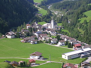
Kals valley
| Kals valley | ||
|---|---|---|
|
Kals am Großglockner |
||
| location | East Tyrol , Austria | |
| Waters | Kalserbach | |
| Mountains | Grossglockner | |
| Geographical location | 47 ° 1 ' N , 12 ° 38' E | |
|
|
||
| height | 2000 to 980 m | |
| length | approx. 22 km | |
The Kalser Tal is a side valley of the Iseltal in East Tyrol . It is completely located in the municipality of Kals am Großglockner and is traversed by the Kalserbach . Kalser Strasse was built between 1912 and 1927 to develop the valley .
geography
The Kalser Tal begins at the confluence of the Kalserbach in the Isel below the hamlet of Unterpeischlach . It then runs in a north-north-east direction, where from south to north are the Unter- and Oberpeischlach, Staniska, Haslach and Arnig fractions . At Lesach, the Kalser Valley finally opens into a basin in which the Lesach , Lana, Ködnitz , Großdorf , Glor and Burg districts are located. At the hamlet of Taurer, the Kals valley ends and merges into the Kals village valley .
The Teischnitz Valley and the Ködnitz Valley are side valleys of the Kals Valley.
literature
- Catholic Tyrolean Teachers' Association (Ed.): District Studies East Tyrol. Innsbruck 2001

