Kaltenbroich
|
Kaltenbroich
City of Bergisch Gladbach
Coordinates: 50 ° 58 ′ 56 ″ N , 7 ° 9 ′ 57 ″ E
|
||
|---|---|---|
|
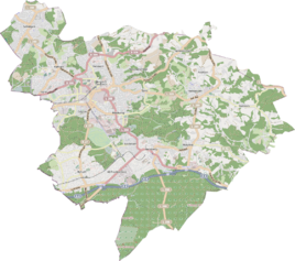
Location of Kaltenbroich in Bergisch Gladbach |
||
|
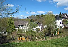
The village of Kaltenbroich with older houses
|
||
Kaltenbroich is a district in the Sand district of Bergisch Gladbach .
history
The settlement of Kaltenbroich was first mentioned in 1660 as Kahlenbroich . In the middle of the 18th century the hamlet had nine farms. By 1905 the place developed under the name Kaltenbruch into a settlement with 20 houses in which 98 residents lived. Today's name Kaltenbroich was created around 1918 . The syllable cold indicates the temperature conditions, while the basic word broich is explained by the damp, swampy soil in the valley. The below-average temperature is explained by the open valley section in the upper Lerbachtal , which is exposed to the north wind.
Mining
In the vicinity of Kaltenbroich, mining was operated on the Blücher pit and the Britannia and Selma pits , on which miners from Kaltenbroich also worked.
Individual evidence
- ^ Andree Schulte Bergisch Gladbach, City history in street names , Bergisch Gladbach 1995, ISBN 3-9804448-0-5 , p. 176 f.
Web links
- Karin M. Erdtmann: Village idyll with a Wild West character . In: Kölner Stadt-Anzeiger (online) from August 1, 2012, accessed on February 2, 2013.


