Graben-A Kamske
|
Graben-A Kamske Kamska |
||
|
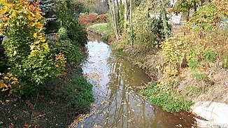
The Kamske at the underpass under Karl-Marx-Straße in the direction of flow |
||
| Data | ||
| Water code | DE : 582552 | |
| location | Oberspreewald , Niederlausitz , Brandenburg , Germany | |
| River system | Elbe | |
| Drain over | Spree → Havel → Elbe → North Sea | |
| Branch | east of Radduscher Kaupen from the Stradower Grenzgraben 51 ° 49 ′ 37 ″ N , 14 ° 4 ′ 21 ″ E |
|
| Source height | approx. 55 m above sea level NHN | |
| muzzle | about two kilometers north of Lübbenau in the Spree Coordinates: 51 ° 53 ′ 8 ″ N , 13 ° 57 ′ 30 ″ E 51 ° 53 ′ 8 ″ N , 13 ° 57 ′ 30 ″ E |
|
| Mouth height | approx. 51 m above sea level NHN | |
| Height difference | approx. 4 m | |
| Bottom slope | approx. 0.21 ‰ | |
| length | 19.4 km | |
The Graben-A Kamske (mostly only briefly and until 1938 Kamske ), Kamska in Lower Sorbian , is a river in the Spreewald in the south of Brandenburg .
etymology
The name Kamske is derived from the Sorbian word kamjeń ("stone") and describes a stony stream. In 1938, the National Socialists renamed the Fließ to “Graben-A” as part of the Germanization of Sorbian field names. Today it is officially called “Graben-A Kamske”, but is mostly referred to as Kamske, among other things on signs.
course
The Graben-A Kamske, in the following referred to only as Kamske, branches off about two kilometers north of Stradow from the Stradower Grenzgraben and initially flows westwards, where it is fed by the Göritzer Fließ and after another two kilometers by the Seeser Fließ . In the further course the Kahnsdorfer Kahnfahrt joins the Kamske. From there, the Kamske runs largely parallel to the Südumfluter .
After about a kilometer and a half, the Kamske meets the Dobra ( ), which flows into the Südumfluter shortly afterwards. On the further course it is fed by several smaller moats and finally passes the city of Lübbenau. There it first passes Poststrasse before turning westwards after almost 50 meters. There the small town moat branches off from the Kamske. After another 50 meters, the Kamske bends north again.
![]()
After another 360 meters, the Kamske first passes the Stottoff street and shortly afterwards Karl-Marx- Straße . About 200 meters later it meets the city moat . There is the Kamske Kahnhafen . In the further course of the Kamske, smaller branch rivers first branch off from the Kamske, before the Kreuzgraben and about 200 meters further the Barbaragraben branch off from the Kamske. After a total length of about 19.4 kilometers, the Kamske finally flows into the Spree about two kilometers northwest of the city center of Lübbenau .
Ecological damage
The original water balance of the Kamske was disturbed by the lignite mining in the Lausitz. The river became known because the ochering or the iron hydroxide load is particularly high in the area due to the water that is channeled into the Spree through the lignite opencast mines.
Individual evidence
- ↑ River directory gewnet25 (Version 4.0, April 24, 2014) at the Ministry for Rural Development, Environment and Agriculture of the State of Brandenburg, accessed on October 20, 2018.
- ↑ Bernd Marx: Secrets behind Spreewald floating names. Lausitzer Rundschau , March 5, 2009, accessed on October 20, 2018 .
- ↑ BrandenburgViewer of the state survey and geographic base information Brandenburg (LGB)
- ^ Sarah Schierack: Eisenocker endangers tourism in the Spreewald. Augsburger Allgemeine , May 7, 2013, accessed October 20, 2018 .
