
Kano (river)
| Kano | ||
 the Kano at Shuzenji (city of Izu) |
||
| Data | ||
| location | Japan | |
| River system | Kano | |
| source | at Amagi 34 ° 50 '36 " N , 138 ° 57' 37" E |
|
| Source height | approx. 1130 m TP | |
| muzzle | at Numazu in Suruga Bay Coordinates: 35 ° 4 '47 " N , 138 ° 51' 20" E 35 ° 4 '47 " N , 138 ° 51' 20" E |
|
| Mouth height | 0 m TP | |
| Height difference | approx. 1130 m | |
| Bottom slope | approx. 25 ‰ | |
| length | 46 km | |
| Catchment area | 852 km² | |
| Drain |
MQ |
17.88 m³ / s |
| Left tributaries | Funabara, Kakinoki | |
| Right tributaries | Kise, Ōmi | |
| Big cities | Numazu | |
| Medium-sized cities | Izu , Izunokuni | |
The Kano ( Japanese 狩 野 川 , Kano-gawa ) is a 46 km long river on the Japanese island of Honshū . It rises at the Amagi volcano , flows through the western part of the Izu Peninsula and flows into Suruga Bay at Numazu . It drains an area with a size of 852 km², which corresponds to about 11% of the area of Shizuoka Prefecture . The Kano is the only river in this prefecture that flows north.
description
The source of Kano located on the west side of the volcano Amagi , the highest elevation of Izu Peninsula - more precisely in the vicinity of the Hatcho pond ( 八丁池 , Hatchōike ) at an altitude of about 1130 m TP The source region is characterized by high rainfall that can be more than 3000 mm per year. As a steeply sloping mountain stream, the Kano initially flows around three and a half kilometers westwards before turning north. At Kayano, the first place on the river, the Kano pours over the 25 m high Jōren waterfall ( 浄 蓮 の 滝 , Jōren-no-taki ), which is listed by the Ministry of the Environment in the list of the top 100 waterfalls in Japan . Then the gradient in the north of the urban area of Izu flattens significantly.
In Mamanoue, a district of Izunokuni , the Kanogawa Relief Canal ( 狩 野 川 放水 路 , Kanogawa hōsuiro ) branches off to the west. At the point where the valley begins to widen into an extensive plain, it absorbs the excess water during the frequent floods and directs it directly into the Enoura Bay, a side bay of the Suruga Bay . In this way, the floods that often occurred in the past in the lower part of the river can be largely prevented or at least contained. The canal is 2.980 km long and between 50 and 120 m wide. It is able to absorb up to 2000 m³ of water per second, whereby the flow rate can be determined with a movable weir . Due to the hilly terrain, the relief channel leads through two tunnels, the Nagaoka Tunnel (850 m) and the Kuchino Tunnel (210 m).
The Kano is known for the large stocks of Ayu fish, and Wasabi is also cultivated in the valley . In the extensive Tagata-plane ( 田方平野 , Tagata heiya ) meandering the flow north-west. At the city limits to Numazu , it takes in the largest tributary, the Kise , which rises at the foot of Mount Fuji . At a short distance it flows west and south to finally flow into Suruga Bay next to the port of Numazu.
history
From the end of the last glacial period until about 6000 years ago, the sea level was a few meters higher than it is today. The Kano Bay, a shallow inlet, reached as far as the Izunokuni area . When the sea level began to gradually decline, the river deposited sediments and the today's Tagata Plain was formed. There have been countless flood events over the centuries. In old river beds, archaeologists came across the remains of flooded villages that date back to the Yayoi period around 2000 years ago. In the Meiji period alone , 42 floods were recorded, and 20 more in the Taishō period . The dams were weak and usually did not last long. In response to the immense damage caused by Typhoon Ione in September 1948, the government pushed ahead with planning a drainage canal. Construction work began in 1951, but progressed slowly.
On September 28, 1958, Typhoon Ida hit the island of Honshū and caused severe damage, especially on the Izu Peninsula. With a speed of over 200 km / h and a rainfall of up to 748 mm on the Amagi volcano , it was the most violent cyclone in Japan since the end of the Pacific War . There were numerous landslides that expanded into streams of debris . The dams broke and the Kano overflowed along the entire middle and lower course of the river. The typhoon raged particularly violently around the city of Izu and surprised the residents in their sleep. A total of 1269 people were killed (853 of them on the Kano alone) and 6,775 houses were destroyed. In Japan, this cyclone is known today as the "Kanogawa typhoon" ( 狩 野 川 台風 , Kanogawa taifū ) and is considered to be one of the most devastating of all. The relief sewer was opened in 1965 after a 14-year construction period.
photos

Joren waterfall

Relief channel

Matsugase suspension bridge
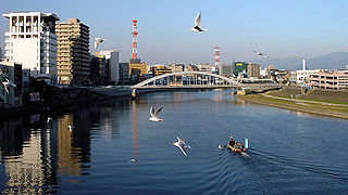
in the center of Numazu
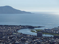
muzzle

.jpg)


Web links
- Information on the Kano catchment area (Japanese)
Individual evidence
- ↑ a b c d 河川 の 総 合 的 な 保全 と 利用 に 関 す る 基本 方針. (PDF, 73 kB) MLIT , accessed on November 19, 2018 (Japanese).
- ↑ 浄 蓮 の 滝. Ministry of Environment , 2008, accessed November 19, 2018 (Japanese).
- ↑ a b c d 狩 野 川 放水 路. (PDF, 7.6 MB) MLIT , accessed November 19, 2018 (Japanese).
- ↑ 狩 野 川 台風 1958 年 9 月 26 日. Izu City website, accessed November 19, 2018 (Japanese).