
Kargassok
| Village
Kargassok
Kargasok
|
||||||||||||||||||||||||||||||||
|
||||||||||||||||||||||||||||||||
|
||||||||||||||||||||||||||||||||


Kargassok ( Russian Каргасо́к ) is a village (selo) in Tomsk Oblast in Russia with 8,127 inhabitants (as of October 14, 2010).
geography
The place is about 375 km as the crow flies northwest of the Tomsk Oblast Administrative Center in the southeast of the West Siberian lowlands . It is located on the left bank of the Ob, which is almost 1.5 km wide, directly below the confluence of the left tributary Parabel and about 8 km above the mouth of the main arm of the Wassjugan .
Kargassok is the administrative center of the Kargassokski Rajons and the seat of the rural community Kargassokskoje selskoje posselenije, which also includes the villages of Bondarka (8 km southwest), Losunga (14 km southwest), Paschnja (9 km south-southeast) and Pavlovo (7 km south-southeast Geolog) and the settlements of Geologitscheski ("Geological settlement", southeast adjoining), Neftjanikow ("settlement of the oil workers", southwest adjoining) and 5 km (3 km west, approximately at kilometer 5 of the old route of the road that leads up the right bank of Vasyugan) belong.
Wooden house in Kargassok

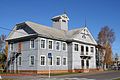
Church in Kargassok

Road with local bus Geologichesky - airport

Passenger ship on the Ob near Kargassok


history
The village was founded in 1640 a few kilometers south of today's location at the left parabolic tributary Ponigadka. The name means something in Selkup "bear headland". In 1875 the settlement Jelowka was built in the area of today's center on the Ob-Ufer , later renamed Pristan ("Landing Point"), then in Nowy Kargassok ("New Kargassok"), while the original place from then on Stary Kargassok ("Old Kargassok" ) was called.
On December 9, 1925, the place became the administrative seat of a Rajons named after him. In the 1930s, the population of Nowy Kargassok grew rapidly as a result of people who were forcibly resettled as part of the deculacization process ; Stary and Nowy Kargassok were temporarily independent districts.
Population development
| year | Residents |
|---|---|
| 1939 | 3903 |
| 1959 | 6564 |
| 1970 | 6972 |
| 1979 | 6751 |
| 1989 | 8450 |
| 2002 | 8547 |
| 2010 | 8127 |
Note: census data
traffic
Kargassok is the end point of regional road 69K-12, which branches off south of Kolpaschewo from 69K-2 Tomsk - Kolpaschewo and leads down the left bank of Ob and Parabel via the neighboring district of Parabel to the southeast . From Kargassok the road runs as 69K-13 up the Wassjugan in the direction of Sredni Wassjugan (90 km passable to below the confluence of the Tschischapka ).
On the western edge of the town there is an airport ( ICAO code UNLK ) that has not been served regularly since the 1990s.
Web links
Individual evidence
- ↑ a b Itogi Vserossijskoj perepisi naselenija 2010 goda. Tom 1. Čislennostʹ i razmeščenie naselenija (Results of the All-Russian Census 2010. Volume 1. Number and distribution of the population). Tables 5 , pp. 12-209; 11 , pp. 312–979 (download from the website of the Federal Service for State Statistics of the Russian Federation)
| Cities |
Assino R | Kedrowy S | Kolpaschewo R | Seversk S / G | Streschewoi S | Tomsk S / R |
|
| Urban-type settlements |
Bely Jar R |
|
| Other Rajon centers |
Alexandrovskoye | Bakshar | Kargassok | Koschevnikowo | Krivoscheino | Melnikovo | Molchanovo | Parabola | Pervomaiskoye | Podgornoje | Syrjanskoye | Tolerated |