
Banatska Palanka Castle
| Banatska Palanka Castle | |
|---|---|
| Alternative name | Translederata ? |
| limes | Dacian Limes |
| section | A / II-III / 6 |
| Dating (occupancy) | traian |
| Type | Equestrian and cohort fort? |
| unit | a) Legio IIII Flavia , b) Legio VII Claudia , c) Ala II Pannoniorum , d) Cohors II Hispanorum , e) Cohors I Cretum |
| size | unknown |
| Construction | Wood-earth construction? |
| State of preservation | The fence is visible in the area |
| place | Banatska Palanka |
| Geographical location | 44 ° 49 '55 " N , 21 ° 20' 25" E |
| height | 70 m. i. J. |
| Previous | Lederata Castle (southeast) |
| Subsequently | Vărădia Castle (northwest) |


Brick stamps of the Cohors II Hispanorum and the Cohors I Cretum
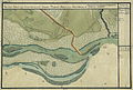
The Danube near Palanka on an 18th century military map (Josephinische Landesaufnahme, 1769–72)


The fort Banatska Palanka was a Roman auxiliary forces camp and part of the fortress chain of the Dacian limes ( limes Daciae / Province Dacia Superior ) in the field of city Palanka ( Serbian - Cyrillic Банатска Паланка , Hungarian Palánk ) in the south of the autonomous Serbian province of Vojvodina , Landscape Banat , Bela Crkva in the Okrug Južni Banat .
It secured together with the crew of the located on the south bank of the Danube fort Lederata an important Danube crossing from Moesia to Dacia . The site is completely unexplored. Readings and brick stamps are now in the Belgrade National Museum.
location
Palanka is located on the north bank of the Danube opposite the village of Ram . The fort was located directly on the banks of the Danube on the important road connection Lederata - Tibiscum , south of today's urban area. In the area, the fortification can still be seen today as a clear elevation.
Development and function
Due to its geographical location, the Banat was one of the main entrance gates to the Dacian provinces for the Romans. One of these connections to the Danube Limes was the road to Tibiscum , which started from the Lederata fort . When building the road, the Romans adhered exactly to the topographical conditions and laid the route on the outer edge of the hill country and a plain.
In the first Dacian War , 101 AD, the main force of Trajan marched from the legionary camp Viminatium and crossed the Danube at Lederata . The pontoon bridge used for this and the bridgehead on the north bank were secured by the fortifications at today's Palanka. From here the troops moved via Arcidava (Värädia), Berzogis and Tibiscum to the Iron Gate Pass and defeated the Dacians in the Battle of Tapae . According to the brick stamps, the fort opposite to the Mösian camp Lederata was initially occupied by legions of the Legio IV Flavia Felix and Legio VII Claudia .
The fort was probably also built by members of these two legions. The ancient name of the base was possibly - based on the fort on the south bank of the Danube - Translederata .
After some terra sigillata shards (type Drag. 37) have been found, it is assumed that a vicus also existed here in the 2nd to 3rd centuries AD . The residents of the civil settlements along the main road probably also provided scouts (exploratores) who were also used for defense, surveillance and security.
Probably then stationed in the fort dropper unit ala II Pannoniorum and Auxiliarkohorten the cohors II Hispanorum scutata Cyrenaica equitata and Cohors I Cretum was responsible for the control of the ship traffic on the current and the monitoring and securing of the road link of Kastell Lederata according Kastell Tibiscum , by the Danube continued into the interior of Dacia. At the beginning of the war, both units were still part of the Moselle army. The Hispanics were probably only stationed here during the First Dacian War and were later relocated to Virset.
Limes course between Banatska Palanka Fort and Värädia Fort (road post)
| Surname | Description / condition |
|---|---|
| Dupljaja Castle | The remains of the auxiliary fort are north of Dupljaja in the area of the Serbian city of Pancevo , on the right bank of the Caras.
The square is also known by its field name "Cetate" (= castle). The fortification can still be seen as a slight elevation in the area, but has never been archaeologically examined. The crew presumably monitored the Lederata - Tibiscum road ; which units were in Dupljaja is unknown. |
| Grebenac castles | These two fortifications are also located in the Serbian town of Pancevo , around one kilometer south of Grebenac.
They are still clearly recognizable as 110 × 130 meters and 60 × 110 meters square elevations. The fort areas are known under the field names "Cetatea Mare" and "Cetatea Micä". They were probably also used to monitor the Lederata - Tibiscum road link . Presumably they were built using the wood and earth technique in Trajan's time. The site has not yet been archaeologically investigated, and the fort's crew is unknown. |
Monument protection
In Serbia, the protection of archaeological objects and zones has top priority and is regulated by the Monument Protection Act (Official Gazette SG RS, 71/94) defined in 1994 with its subsequent amendments and additions as well as by special decrees. The Serbian Monuments Office in Belgrade, which belongs to the Ministry of Culture, is responsible. Research and targeted collection of finds are subject to authorization. The damage and destruction of archaeological finds and sites must be reported to the authorities within 24 hours. No antiquities may be taken out of the country without consulting the Serbian Monument Authority. Offenses are punished as criminal acts according to Serbian law. Checks are to be expected when entering the European Union.
See also
literature
- Nicolae Gudea : The Dacian Limes. Materials on its story . In: Yearbook of the Römisch-Germanisches Zentralmuseum Mainz , 44, 2 (1997), p. 25 ( PDF ).
- Doina Benea: The economic activity in the village branches between Theiss, Marosch and Danube. In: Studia Antiqua et Archaeologica 9 (2003), pp. 299-318.
further reading
- Nicolae Gudea: Limesul Daciei romanc de la Traianus la Aurelianus. In: Acta Musei Porolissensis 1, 1977. p. 109 (in Romanian).
- Nicolae Gudea: The Limes Dakiens and the defense of the Upper Moesian Danube line from Trajan to Aurelian. In: Rise and Fall of the Roman World . Part II, Volume 6. Walter de Gruyter, Berlin-New York 1977, ISBN 3-11-006735-8 , p. 871 (therein p. 871: 12. List of military camps ).
- Felix Milleker : Délmagyarország régiségleletei a honfoglalás előtti idökböl. (The archaeological finds of southern Hungary before the time of the conquest.) Temeschburg 1899, p. 245 (in Hungarian).
- Draga Garasanin: Catalog metala, Catalog of Prehistoric Metals , National Museum Belgrade, Katalozi Prajstoria 1954, p. 217.
- Jan Benes: Auxilia Romana in Moesia atque in Dacia: on the questions of the Roman defense system in the Lower Danube region and in the adjacent areas. Academia Verlag, Prague 1978, pp. 39-40.
- Karl Strobel : Investigations into the Dacer wars of Trajan. Studies on the history of the middle and lower Danube region in the High Imperial Era . Habelt, Bonn 1984, ISBN 3-7749-2021-4 (= Antiquitas 1, 33).
- Karl Strobel: Domitian's Danube Wars . Habelt, Bonn 1989 (= Antiquitas 1, 38), ISBN 3-7749-2368-X .
- A. Jovanovic: The problem of the location of Lederata. In: Petar Petrović, Slobodan Dušanić (ed.): Roman Limes on the Middle and Lower Danube. Archaeological Institute, Belgrad 1996, pp. 69-72.
- Milanka Bordevic: Limes Danube. 1996.
Web links
Remarks
- ^ Route / section / fort number (based on Nicolae Gudea , 1997).
- ↑ List is from SE to NW.
Individual evidence
- ↑ Jovanović: 1996, pp. 69-72.
- ↑ Doina Benea: 2003, p. 300.
- ^ Karl Strobel: 1989, p. 244.
- ↑ Doina Benea: 2003, pp. 302-305.
- ↑ CIL 3, 8074 .
- ^ Karl Strobel: 1984, p. 135.
- ↑ Nicolae Gudea: 1997, p. 25; Milanka Bordevic: 1996, p. 131.
- ↑ Nicolae Guidea: 1997, pp. 25-26.
- ↑ The official regulations on the website of the Serbian Monument Protection Agency ( Memento from October 1, 2012 in the Internet Archive ), wayback, (in Serbian).
Banatska Palanka Castle (Translederata) | Dupljaja Castle | Grebenac Castle | Vărădia Castle (Arcidava) | Vršac Castle | Surducul Mare Castle (Centum Putei) | Berzovia Castle (Bersobis) | Fort Fârliug (Aizis)