
Fort Stuttgart-Bad Cannstatt
| Fort Stuttgart-Bad Cannstatt | |
|---|---|
| Alternative name | Cannstatt Castle Bad Cannstatt Castle |
| limes | ORL 59 ( RLK ) |
| Route (RLK) |
Neckar-Odenwald-Limes Neckar line |
| Dating (occupancy) | around 85/90 AD to 160 AD Vicus until 230, at the latest 260 AD |
| Type | Alenkastell |
| unit | Ala I Scubulorum (?) |
| size | a) 185 × 160 m = 3 ha b) 215/220 × 171 m = 3.7 ha |
| Construction | a) Wood and earth fort. b) Stone fort |
| State of preservation | overbuilt |
| place | Stuttgart-Bad Cannstatt |
| Geographical location | 48 ° 48 '48 " N , 9 ° 12' 39" E |
| height | 248 m above sea level NHN |
| Previous | ORL 58 Benningen Fort (north) |
| Subsequently | ORL 60 Köngen Castle (south) |
The Stuttgart-Bad Cannstatt Fort , often referred to in the literature as Cannstatt Fort , more rarely Bad Cannstatt Fort , was a Roman military camp on the Neckar line of the Neckar-Odenwald-Limes . It is located as a ground monument in what is now a largely built-up area of Bad Cannstatt , a district of the Baden-Württemberg state capital, Stuttgart .
location

The fort was located west of the Neckar on a hill about 450 m away from the river in a strategically and geographically favorable position. Here the Roman road , which led from Mogontiacum ( Mainz ) to Augusta Vindelicorum ( Augsburg ), crossed the route running along the Neckar. In addition, a trunk road from Argentorate (Strasbourg) came across this intersection. The Neckar Valley and the streets of the Neckartrasse leading to the neighboring forts Benningen and Köngen , as well as further to Wimpfen and Arae Flaviae ( Rottweil ), could be monitored from the fort, which is a good 25 m above the river .
Research history
Roman inscription stones were documented in the Cannstatt area as early as the 16th century. The first finds from the "Altenburger Feld", the location of the Cannstatt Fort, were recorded in the 18th century. Systematic, modern archaeological excavations were then undertaken between 1894 and 1896 by the Reich Limes Commission in cooperation with the Cannstatter Altertumsverein and Württemberg state authorities. Before the final development in 1908, major investigations were carried out again.
After around 1700 years, barracks were rebuilt on the site , again for a cavalry unit . Since the last military users left the area in 1993, the area and its buildings have been used as a combined residential and small business area. Further large-scale archaeological investigations are therefore no longer expected in the near future.
The finds from previous excavations are in the Provincial Roman Collection of the Württemberg State Museum , which is housed in its branch in the Old Castle .
Findings

With dimensions of 185 × 160 meters, the wood-earth warehouse covered an area of almost three hectares. It was surrounded by a pointed ditch 6 to 7 m wide and 2 to 3 m deep . Only small traces of the interior development could be found, it must have consisted exclusively of wooden or half-timbered buildings.
With a length of 215 to 220 m and a width of almost 171 m, the stone fort was 3.7 hectares in size and also surrounded by a pointed moat. Its width varied between 4.5 and 8 m, the depth between only 1.0 and 1.5 m. The camp with its Porta praetoria (main gate) was oriented towards the southeast, towards the Neckar, and was reinforced with a wall rounded at the corners. Corner and intermediate towers could only be detected in the Retentura (rear storage area), but all four gates were secured with double towers.
Of the interior buildings, apart from the central principia (staff building), only parts of two other stone buildings of unclear purpose were found. On the other hand, the roads paved with gravel and stones could be examined more closely. The width of the main axes varied between eight meters on the Via praetoria (arterial road) and twelve meters on the Via principalis (main warehouse street ). In contrast, the width of the Via sagularis (Lagerringstrasse), which ran parallel to the wall, was only four meters.
The civil camp village, the vicus , extended mainly north of the fort in the extensions of the via decumana (rear camp road) and the via principalis dextra (right main camp road). The buildings located here are half-timbered houses with a cellar, some of which had hypocaust systems . The discovery of a pottery workshop with a total of 40 kilns was remarkable. A temple dedicated to the Magna Mater and Diana as well as a giant column of Jupiter can be assumed to be probable based on the location.
In front of the north-west corner of the fort, the floor plans of a beneficiary station including an altar came to light. The beneficiaries were a kind of road police with customs powers who were responsible for the security of the Roman highway network. The fact that there were two such posts in the Roman Bad Cannstatt underlines its importance as a road junction. The second beneficiary station could be located on the right side of the Neckar near today's Uff-Kirchhof .
Fort and vicus history

The fortress of Stuttgart-Bad Cannstatt was built in Domitian times, probably between 85 and 90 AD, initially as a wood-earth structure. It belonged to a series of a total of six military installations with which a stretch of around 60 km along the Neckar was militarily secured, which stretched from the Wimpfen fort in the valley to the Köngen fort .
The Ala I Scubulorum recruited in Spain , a cavalry unit of around 500 men , is generally accepted as the unit stationed in Cannstatt .
Around the year 100, the simple wood and earth fort was replaced by a camp with a stone fence. In the years from AD 159/160, the Limes, which until then had run just east of the Neckar, was relocated around 30 kilometers to the east. In the course of this operation, the fort in Bad Cannstatt was also abandoned, while the vicus continued to exist. This Roman civil settlement in a geographically favorable location is considered to be one of the larger Roman settlements in what is today Baden-Württemberg due to archaeological finds. It is unlikely to have existed in its full size beyond the beginning of the 3rd century, since the occupancy of the burial fields has declined drastically from the turn of the century. The beneficiary station, however, can still be proven for the year 230. With the fall of the Limes around 259/260 AD , the Roman presence in the Stuttgart area is likely to have come to an end.
Around the year 236, a battle possibly took place near Bad Cannstatt as part of the counter-offensive initiated by Emperor Maximinus Thrax against the Alemanni, who first invaded Roman territory in 233. In any case, a tombstone found in Bad Cannstatt in 1930 was often interpreted in this sense; it documents the death of two brothers of the Ala nova firma milliaria catafractaria ("New Ala, nicknamed the festivals, double strength and armored") in battle. This troop is a special unit of the heavy cavalry from Persia, in which the horse and rider were armored. The more recent research, however, interprets this inscription, which cannot be precisely dated, much more cautiously, even if it has been archaeologically proven since around 2010 ( Battle of the Harzhorn ) that the Roman counter-offensive of 235/236 actually reached deep into the Germanic area.
Illustrations


Details of the fort fortifications
(excavations 1894–96)
Graffiti, small finds and architectural
elements (excavations 1894–96)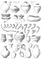
Ceramic finds
(excavations 1894–96)
Pottery stamp
(excavations 1894–96)


Monument protection
The ground monument "Kastell Bad Cannstatt" is protected as a registered cultural monument within the meaning of the Monument Protection Act of the State of Baden-Württemberg (DSchG) . Investigations and targeted collection of finds are subject to approval, and accidental finds are reported to the monument authorities.
See also
literature
- Dietwulf Baatz : The Roman Limes. Archaeological excursions between the Rhine and the Danube. 4th edition. Gebr. Mann, Berlin 2000, ISBN 3-7861-2347-0 , pp. 210f.
- Philipp Filtzinger : Stuttgart-Bad Cannstatt. In: Dieter Planck (Ed.): The Romans in Baden-Württemberg . Theiss, Stuttgart 2005, ISBN 3-8062-1555-3 , p. 327ff.
- Philipp Filtzinger: Stuttgart-Bad Cannstatt . In: Filtzinger, Planck, Cämmerer (ed.): The Romans in Baden-Württemberg . 3. Edition. Theiss, Stuttgart 1986, ISBN 3-8062-0287-7 , p. 573ff.
- Jörg Scheuerbrandt : Pannonian riders as ala firma catafractaria in Stuttgart-Bad Cannstatt. A contribution to the troop history of the 3rd century AD. In: Gabriele Seitz: In the service of Rome. Festschrift for Hans Ulrich Nuber . Greiner, Remshalden 2006, ISBN 3-935383-49-5 , pp. 299-305.
- Walter Barthel and Ernst Kapff in the series Der Obergermanisch-Raetische Limes des Roemerreiches (Eds. Ernst Fabricius , Felix Hettner , Oscar von Sarwey ): Department B, Volume 5, Fort No. 59 (1907).
Web links
- Fort Bad Cannstatt on the private site for the preservation of monuments in Baden-Württemberg by Wolfgang M. Werner
Remarks
- ↑ For the current use of the site, see the MKM Römerkastell GmbH & Co. KG website .
- ↑ In particular in Filtzinger 2005, p. 327 and in other publications. Baatz 2000, p. 210, on the other hand, suggests that only one Ala I is secured in the inscription. There were three of them: the Ala I Scubulorum , the Ala I Flavia Gemina and the Ala I Indiana Gallorum .
- ↑ grave Tele the Katafraktarier Aurelius Saluda and Regrethus ; Stuttgart, State Museum Württemberg, Inv.-No. RL425
- ↑ cf. in detail: Rainer Wiegels: On the army formations of Rome on the Rhine and Upper Danube in the time of Alexander Severus and Maximinus Thrax , De Gruyter, Klio 2014; 96 (1): 93-143; here pp. 125–133.

Fort Wimpfen im Tal | Heilbronn-Böckingen fort | Castles of Walheim | Benningen Fort | Fort Stuttgart-Bad Cannstatt | Castle Köngen (Grinario) | Rottenburg Castle (Sumelocenna) | Sulz Castle | Waldmössingen Castle | Castles of Rottweil (Arae Flaviae)