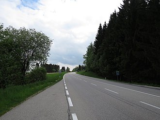
Kerschbaumer Sattel (Upper Austria)
| Kerschbaumer saddle | |||
|---|---|---|---|
|
Pass height |
|||
| Compass direction | North | south | |
| Pass height | 714 m above sea level A. | ||
| state | Upper Austria | ||
| Watershed | Maltsch → Moldau | Feldaist → Danube | |
| Valley locations | Wullowitz | Rainbach in the Mühlkreis | |
| expansion | Mühlviertler Strasse (B 310) | ||
| Mountains | Bohemian mass | ||
| Map (Upper Austria) | |||
|
|
|||
| Coordinates | 48 ° 35 '28 " N , 14 ° 28' 39" E | ||
The Kerschbaumer saddle in the Mühlviertel is a mountain saddle with 714 m above sea level. A. and an important transition from the Danube region in Upper Austria to South Bohemia for centuries . It is entirely located in the municipality of Rainbach im Mühlkreis , north of the district of Kerschbaum . The saddle forms the European watershed between the Danube and the Vltava .
history
A mule track was laid over this saddle as early as the Bronze Age , which has been proven by relevant finds. In the Middle Ages, an important salt route ( Goldener Steig , Linzer Steig ) led from Linz via Freistadt to Budweis over the saddle. This path was chosen because it was much shorter than the one over the 680 m above sea level. A. lying Feldaist valley near Summerau (community Rainbach) .
Around 1823 the Linz-Budweis horse-drawn railway followed the route of the Salzweg in this area and the most important stop was built south of the saddle, which has now been converted into a museum. The Kerschbaumer Sattel was also the highest point of the route, from which 500 meters are now accessible again, between the village of Kerschbaum and the museum.
Today the Mühlviertler Straße (B 310) leads over the saddle and the planned Mühlviertler expressway (S 10) is also to lead over the saddle from 2020.
Spatial assignment
In the literature of the first years of the 20th century, the approximately 25 km wide area between the Sternstein ( 1122 m above sea level ) and the Viehberg ( 1112 m above sea level ) is called the Kerschbaumer Sattel . That is why the saddle was also considered the easternmost end of the Bohemian Forest to the Freiwald .
Since the middle of the 20th century, this entire area has been referred to as the Feldai Valley and the Kerschbaumer Sattel is part of this valley. The area between the Dorfberg ( 792 m above sea level ) near Kerschbaum and the Leopoldschläger Berg ( 879 m above sea level ) near Pramhöf (municipality of Leopoldschlag ) is known as the Kerschbaumer Sattel .
Web links
- Entry on Kerschbaumer Sattel in the Austria Forum (in the AEIOU Austria Lexicon )
- Fritz Fellner: Common history of the Mühlviertel-South Bohemia. Blog from January 16, 2008.
Individual evidence
- ^ Josef Kneidinger: Prehistoric finds from the Mühlviertel. Dissertation, Vienna 1939, No. 23.
- ↑ Wissen.de: Böhmerwald ( page no longer available , search in web archives ) Info: The link was automatically marked as defective. Please check the link according to the instructions and then remove this notice. , accessed November 10, 2008
- ^ Josef Matznetter: Geomorphological observations in the southernmost section of the Danube-Elbe watershed. In: Yearbook of the Upper Austrian Museum Association. 93, Linz 1948, p. 255, entire article, p. 255-273, PDF on ZOBODAT

