
Small fort Gheriat esh-Shergia
| Small fort Gheriat esh-Shergia | |
|---|---|
| Alternative name | Gheriat's Scerghia |
| limes |
Limes Tripolitanus front Limes line |
| Dating (occupancy) |
pre-Severan or Severan until shortly after AD 260? |
| Type | Small fort |
| size | 38.80 m × 26 m (= 0.10 ha) |
| Construction | stone |
| State of preservation | rectangular floor plan with rounded corners |
| place | Qaryat |
| Geographical location | 30 ° 23 '28.5 " N , 13 ° 35' 25.1" E |
| height | 480 m |
| Previous | Small fort Gasr Zerzi (east) |
| Subsequently | Gheriat el-Garbia fort (west) |
| Backwards |
Fort Mizda (northwest) , small fort Gasr Bularkan (northeast) |

The small fort Gheriat esh-Shergia , also Gheriat es Scerghia , is a former Roman military camp , the crew of which was responsible for security and surveillance tasks on the Limes Tripolitanus , a deep system of forts and military posts in the Roman province of Africa proconsularis or Numidia . The small fortification, which was converted into an Italian fort in the early 20th century, is located in the oasis of the same name on the northern edge of the Fessan and the Sahara in the Munizip al-Dschufra in Libya . Today's oasis town of Qaryat is nearby . The towering remains of the surrounding wall of the small fort can be seen on a rock spur above the road leading from the north to the desert town of Ash Shurayf.
location
The garrison site, built for a small division, was built on a rock spur around 300 meters long and between 260 and 330 meters wide, rising to the south, west and north. This as Plateau trained survey falls over a cliff with a lot of debris rubble about 20 meters to the south-western oasis from back. Its center is located in a narrow northeast-oriented wadi , which rises around one kilometer south of the rock spur to around 490 meters in altitude. The fortification, which dominates the square far and wide, only occupies the southern area of the rock spur, but the view to the north is very limited. In the area of the wadi, a historical trade route runs into the Fessan from the north. There was visual contact with the nearest 2.25-hectare fort at Gheriat el-Garbia, which was around 20 kilometers away. There was also the option of a signal connection. The modern oasis is located west of the fort. It is connected to the city of Mizda ( Fort Mizda ) by a previously well-developed road, which was completely renewed between 1980 and 1981 . The oases Gheriat esh-Shergia and Gheriat el-Garbia are at the end of two side wadis, both of which flow into the large Wadi Zemzem. To the west of them extends the inhospitable rock plateau of the Hammada al-Hamra .
Research history
The British archaeologist Richard Goodchild (1918–1968) was one of the first who was able to draw a comprehensive picture of Roman settlement and the Limes Tripolitanus in this region through his many years of research in Tripolitania . It was also he who visited Fort Bacone near Gheriat esh-Shergia, which had been abandoned by the Italian troops after the African campaign was lost (1940-1943), to look for the remains of the small fort. In 1949 he and his colleague John Bryan Ward-Perkins (1912–1981) reported for the first time about this site. In the early 1970s, the French archaeologist René Rebuffat visited the site. The next important investigation took place in 1980 under the British archaeologist David Mattingly , who took part in a multi-year UNESCO program (UNESCO Libyan Valleys Survey), which, among other things, was supposed to clarify how the Romans had managed to reduce agricultural use in the barren regions of the to make the Libyan hinterland bloom.
Building history
As in the early 20th century, when the Italian garrison set up a new garrison at the fort, there was already an important trade route into Fessan at the oasis of Gheriat esh-Shergia. This fact will have induced the responsible Roman officers and surveyors to set up a military post at this dominant place. At the larger military site Gheriat el-Garbia there was also access to the Fessan, but the route via Gheriat esh-Shergia seems to have been more important. In this sense, the little Gheriat esh-Shergia could be viewed as the distant "eye" of Gheriat el-Garbia. The square also offered a last chance to grab water, dates, grain and vegetables in order to be able to pass the onward journey via the bare Hammada al-Hamra.
The rectangular, 38.80 × 26 meters (= 0.10 hectare) enclosing wall, very well preserved on three sides, has been preserved up to a height of around seven meters. It consists of very neatly prepared ashlar blocks with a maximum height of 0.70 meters and was extracted from existing limestone. The corners of the building that have been preserved are slightly rounded and beveled, a feature that was also found at the small fort Gasr Banat . The foundation of both structures protrudes slightly. There was also datable ceramics that refer to the third century AD. It is not yet clear what the interior of Gheriat esh-Shergia might have looked like, but according to Mattingly there are signs on the rougher inside of the surrounding wall that walls had been added there. The scientist recognized that the rectangular cuboids visible from the outside inside the small fort were originally backed and reinforced with quarry stone masonry. However, this masonry has almost completely fallen off and / or destroyed. Immediately against this inner wall, in turn, apparently came the room-dividing wall sections structuring the building inside. Overall, an originally at least two-story building can be expected. The access to one of the interiors that has been destroyed today can still be determined from a pair of massive threshold stones that appear to have been preserved in situ . Since the three preserved sides of the surrounding wall do not have any breakthroughs that could indicate an entrance to the small fort, this access must have been made from the now destroyed southeast side, which lay over the slope towards the oasis.
It is not known which unit occupied the small fort. Therefore it cannot be said whether a regular unit, a vexillation of the troops located in Gheriat el-Garbia or Limitanei were stationed here.
- Small fort Gheriat esh-Shergia (2006)
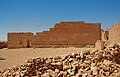
View of the north-eastern outer wall of the small fort with neatly placed ashlar stones. In contrast, there are the Italian add-on buildings made of rubble stones.

The photo shows the north-west side of the fort with the stair tower from Italian times in front of it.


Dating
As the British archaeologist David Mattingly pointed out, in the past it was generally assumed that the small fort of Gheriat esh-Shergia was younger than the much larger complex of Gheriat el-Garbia, which, based on the building inscription discovered in 1965 and published in 1966, was probably in the years 198 to 201 AD, the time of the governor Quintus Anicius Faustus (198-201), can be dated. Anicius Faustus, who was in office during the reign of Emperor Septimius Severus (193-211), had the Roman external border to the south expanded militarily as legatus Augusti pro praetore of the newly constitutionally established province of Numidia and established several new types of garrison. Mattingly saw it as conceivable that Gheriat esh-Shergia could also be older, i.e. a pre-Severan foundation. As possible evidence for this thesis, the archaeologist used the evidence he had found at the rear of the Gasr Banat, the construction of which is very similar to that of Gheriat esh-Shergia. In addition, so-called “African Red Slip Ware” (ARS), a type of Terra Sigillata produced in North Africa , could be dated at the Gasr Banat . According to the catalog drawn up by ceramics expert John W. Hayes , the ARS from Gasr Banat belongs to type 27 and was thus manufactured between the years 160 and 220 AD.
The archaeologist Michael Mackensen could imagine that the border forts advanced far to the south, such as Fort Gheriat el-Garbia - and thus also the nearby Gheriat esh-Shergia - as well as the fort Gholaia / Bu Njem that he investigated shortly after AD 260 Were abandoned in order to move the Tripolitan border back to the north. The use of the Cohors VIII Fida (equitata) could give an indication of this development . Daily reports from Fort Gholaia received on Ostraca show that some equites of the Cohors VIII Fida were detached from their ancestral unit in the Fort Secedi to Gholaia as dispositi at least in the years 258/259 AD. among other things to do service as a rider. As early as 263 AD, the cohort had been ordered around 600 kilometers to the northwest in order to build its new location, the Talalati fort / Ras el Ain in what is now Tunisia . The time window in which the troop was postponed is therefore between 259 and 263 AD. Severe defeats on other border sections of the empire, including the final fall of the Limes in the Germanic provinces, internal Roman conflicts, troop shortages and strategic considerations could have forced Emperor Gallienus (260–268) at the height of the imperial crisis to make the political decision to take this step.
Post-pastoral use
In the course of the Italo-Turkish War from 1911 to 1912, Italian troops were able to end the centuries of Turkish occupation of Libya in order to take possession of the country as a new colonial power. In July 1928, during a domestic uprising, the Italian military was relocated from the Mizda area to Gheriat esh-Shergia and the place was occupied on July 14, 1928. Until 1943, the former small Roman fort then existed as a completely new and greatly expanded Italian redoubt under the name Bacone. Apparently, the Italians were not squeamish about the ancient building fabric. After Goodchild had inspected the remains of the building in the years after World War II , he assumed that the southeastern perimeter wall would have broken down the slope at some point. Instead, an archaeological study conducted by Mattingly in 1980 gave an entirely different picture. Thereafter, this wall could have been torn down when the Italians integrated the Roman structure into their new fort. Instead of the ancient walls, a number of offices and other rooms necessary for a fort were built there. Almost all other remains of the Roman interior buildings seem to have been destroyed by the conversion for military use in the 20th century.
- Fort Bacone (2006)

View from the Italian stair tower on the northwest wall over the northeast perimeter wall. The fixtures also come from Italian times. The ancient ashlar masonry is clearly visible.

North-east wall and north-east tower of Fort Bacone as well as the slope down to the oasis. The wide view into the Fessan, which was also offered to the Roman occupiers, becomes clear.


literature
- David J. Mattingly : Tripolitania. University of Michigan Press, 1997, ISBN 0-472-10658-9 , p. 104.
- Graeme Barker , David Gilbertson, Barri Jones, David J. Mattingly (Eds.): Farming the Desert. The UNESCO Libyan Valleys Archaeological Survey. Volume One: Synthesis . UNESCO, Paris 1996 (inter alia), ISBN 92-3-103214-3 .
- Graeme Barker, David Gilbertson, Barri Jones, David J. Mattingly (Eds.): Farming the Desert. The UNESCO Libyan Valleys Archaeological Survey. Volume Two: Gazetteer and Pottery . UNESCO, Paris 1996 (et al.), ISBN 92-3-103273-9 .
- Richard Goodchild : Oasis forts of Legio III Augusta on the routes to the Fezzan . In: Papers of the British school at Rome 22 (1954), pp. 56-68; here: pp. 60–62.
- Richard Goodchild, John Bryan Ward-Perkins : The Limes Tripolitanus in the Light of Recent Discoveries . In: The Journal of Roman Studies 39 (1949), pp. 81-95; here: p. 93.
Remarks
- ^ A b Michael Mackensen : forts and military posts of the late 2nd and 3rd centuries on the "Limes Tripolitanus" . In: Der Limes 2 (2010), pp. 20–24; here: p. 22.
- ^ Graeme Barker , David Gilbertson, Barri Jones, David J. Mattingly (Eds.): Farming the Desert. The UNESCO Libyan Valleys Archaeological Survey. Volume Two: Gazetteer and Pottery . UNESCO, Paris 1996 (inter alia), ISBN 92-3-103273-9 , p. 125.
- ↑ a b c d e f g David J. Mattingly : Tripolitania. University of Michigan Press, 1997, ISBN 0-472-10658-9 , p. 104.
- ^ A b c d e Richard Goodchild (1951): Roman sites on the Tarhuna plateau of Tripolitania . In: Libyan studies. Select papers of the late RG Goodchild. Elek, London 1976, ISBN 0-236-17680-3 , pp. 43-77; here: p. 50.
- ↑ Fort Mizda at 31 ° 26 ′ 41.76 ″ N , 12 ° 58 ′ 48.71 ″ E
- ^ Graeme Barker , David Gilbertson, Barri Jones, David J. Mattingly (Eds.): Farming the Desert. The UNESCO Libyan Valleys Archaeological Survey. Volume One: Synthesis . UNESCO, Paris 1996 (inter alia), ISBN 92-3-103214-3 , p. 21.
- ↑ Kastell Gheriat el-Garbia at 30 ° 25 '12.2 " N , 13 ° 25' 7.1" O
- ↑ Olwen Brogan : Obituary - Richard Goodchild . In: Azania. Archaeological Research in Africa 3 (1968), p. 9.
- ^ Richard Goodchild, John Bryan Ward-Perkins : The "Limes Tripolitanus" in the Light of Recent Discoveries . In: The Journal of Roman Studies 39 (1949), pp. 81-95; here: p. 93.
- ↑ René Rebuffat : Trois nouvelles campagnes dans le sud de la Tripolitaine . In: Comptes rendus des séances de l'Académie des Inscriptions et Belles-Lettres 4 (1975), pp. 495-505; here: p. 499.
- ^ Graeme Barker , David Gilbertson, Barri Jones, David J. Mattingly (Eds.): Farming the Desert. The UNESCO Libyan Valleys Archaeological Survey. Volume Two: Gazetteer and Pottery . UNESCO, Paris 1996 (inter alia), ISBN 92-3-103273-9 , p. 125.
- ↑ David Gilbertson, Peter Hayes, Graeme Barker, Chris Hunt (Eds.): The UNESCO Libyan Valleys Survey VII: An Interim Classification and Functional Analysis of Ancient Wall Technology and Land Use . In: Libyan Studies 15 (1984), pp. 45-70; here: p. 70.
- ↑ a b Richard Goodchild (1954): Oasis forts of Legio III Augusta on the routes to the Fezzan . In: Papers of the British school at Rome 22 (1954), pp. 56-68; here: p. 62.
- ↑ Small fort Gasr Banat at 31 ° 27 ′ 42.61 ″ N , 14 ° 42 ′ 16.3 ″ E
- ^ Michael Mackensen , Hans Roland Baldus: Military camp or marble workshops. New investigations in the eastern area of the Simitthus / Chemtou labor and quarry camp. Philipp von Zabern, Mainz 2005, ISBN 3-8053-3461-3 , p. 72 (footnote).
- ↑ a b Richard Goodchild (1954): Oasis forts of Legio III Augusta on the routes to the Fezzan . In: Papers of the British school at Rome 22 (1954), pp. 56-68; here: p. 60.
- ^ Graeme Barker , David Gilbertson, Barri Jones, David J. Mattingly (Eds.): Farming the Desert. The UNESCO Libyan Valleys Archaeological Survey. Volume Two: Gazetteer and Pottery . UNESCO, Paris 1996 (inter alia), ISBN 92-3-103273-9 , p. 99.
- ^ Joachim Ott: The Beneficiarier. Investigations into their position within the hierarchy of the Roman army and their function . (= Historia. Einzelschriften 92), Steiner, Stuttgart 1995, ISBN 3-515-06660-8 , p. 25.
- ^ John S. Wacher, The Roman world , Volume 1, Routledge, London / New York 2002, ISBN 0-415-26315-8 , pp. 252-253.
- ^ David J. Mattingly: Farming the Desert. The UNESCO Libyan Valleys Archaeological Survey. Gazetteer and pottery . Volume 2, UNESCO, 1996, ISBN 92-3103273-9 , p. 263.
- ↑ a b Michael Mackensen : Crew accommodation and organization of a Severan legionary vexillation in the Tripolitan fort Gholaia / Bu Njem (Libya) . In: Germania 86.1, 2008 (2009), pp. 271-306; here: p. 286.
- ↑ Hans Ulrich Nuber : The end of the Upper German-Raetian Limes - a research task. In: Hans Ulrich Nuber u. a. (Ed.): Archeology and history of the first millennium in southwest Germany (= Archeology and History 1), Sigmaringen 1990, pp. 51–68.
- ^ Gustavo Pesenti: Le guerre coloniali , Zanichelli, Bologna 1947, p. 325.
- ^ Ministerio della Guerra (Ed.): Bollettino ufficiale delle nomine, promozioni e destinazioni , 1929, p. 955.