Kleinlichtenhain
Small Lichtenhain (also small Lichtenhain or "small Tettauer Zipfel") was an existing out former three residential buildings district of the former town Lichtenhain bei Gräfenthal in the district Neuhaus am Rennweg , Suhl district , German Democratic Republic . It bordered directly on the municipality of Kleintettau , located in the Federal Republic of Germany , in the Kronach district , Upper Franconia . In divided Germany , the place received unusual treatment due to its location.
location
The area of Kleinlichtenhain is located in the south of Thuringia in the district of Saalfeld-Rudolstadt and protrudes into Bavarian territory in the form of a strip approximately 100 meters wide and almost one kilometer long . On the Bavarian side, it borders on the Kleintettau district of the Tettau market in the Kronach district, Upper Franconia. Part of the former village of Kleinlichtenhain has belonged to Kleintettau since 1976. The area is directly south of the Rennsteig .
history
Kleinlichtenhain belonged to the Duchy of Saxony-Meiningen until 1918 and then to the Free State of Saxony-Meiningen , which became part of the state of Thuringia , which was founded in 1920 .
With the establishment of the occupation zones after the end of the Second World War , Thuringia and thus also Kleinlichtenhain belonged to the Soviet and Bavaria to the American occupation zone . The place was characterized by the fact that the three residential buildings that existed at the time were directly adjacent to Kleintettau, so that at this point the Thuringian area not only cut noticeably far into Bavaria, but the zone boundary also ran through a contiguous settlement area. However, Soviet soldiers could not be seen in this rather remote piece of land. Even Americans did not enter the place. When barbed wire fences were later built, this piece of land was left out. The residents of the three houses felt they belonged to Kleintettau, received their ration cards and identity cards there and sometimes, from 1958 onwards, regularly took part in the elections for the local council, the Bavarian state parliament and the Bundestag . The residents, around 25 in total, initially paid no taxes at all until the Kronach tax office reported a few years later.
In March 1962, the course of the planned border installations with barbed wire and death strip between Thuringia and Bavaria was planned, whereby the Kleinlichtenhain houses, from Thuringia's point of view, remained directly on the demarcation line beyond the border installations. On March 21, 1962, the night before the planned start of construction of the border fortifications, 17 people's police officers visited the three houses in order to bring the then twenty residents into the hinterland. 18 of them fled with a few important things over to West German territory. The people's police then left Kleinlichtenhain again, and a couple stayed in one of the houses in this soon-to-be-closed area. The other two houses fell into disrepair.
In the following time strange conditions applied in Kleinlichtenhain. The postman was not allowed to deliver any mail there, police officers were not allowed to enter the area, as were employees of the Kleintettau community. But even for the residents of Kleintettau, entering the GDR strip of land was not without danger.
The border course was finally changed by the German-German border commission in the Kleinlichtenhain area so that from March 1, 1976 the remaining house belonged to the municipality of Kleintettau in the district of Kronach and thus to the Federal Republic. The two abandoned houses were demolished.
The community of Kleintettau was incorporated into the Tettau market on May 1, 1978.
Commemoration
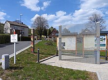
In September 2019, the Kleinlichtenhain border monument was inaugurated, which is intended to commemorate the history of the place during the German division and whose information boards are to be supplemented with documentary photos over time.
Individual evidence
- ↑ Guido Berg: Big gestures asked for Kleintettau. About the rehabilitation of a Bavarian-Thuringian road and the fight for funding from two Free States. (No longer available online.) Ostthüringer Zeitung , February 25, 2017, archived from the original on February 17, 2020 ; accessed on February 17, 2020 .
- ↑ a b Veronika Schadeck: A sign against forgetting. The "Klein Lichtenhain" border monument was inaugurated in Kleintettau. It is intended to remind people of the inner-German border and raise awareness of freedom and democracy. (No longer available online.) InFranken.de , September 13, 2019, archived from the original on February 17, 2020 ; accessed on September 13, 2019 .
- ↑ a b Peter Fiedler: Monument for a miracle. (PDF) Kleinlichtenhain was on the territory of the GDR. The citizens of the place actually lived in the Federal Republic. You will now be thought of, in Kleintettau. (No longer available online.) New Press , September 14, 2019, archived from the original on February 17, 2020 ; accessed on September 14, 2019 .
- ^ Federal Statistical Office (ed.): Historical municipality directory for the Federal Republic of Germany. Name, border and key number changes in municipalities, counties and administrative districts from May 27, 1970 to December 31, 1982 . W. Kohlhammer, Stuttgart / Mainz 1983, ISBN 3-17-003263-1 , p. 690 .
literature
- No man's land at the zone border . In: Die Zeit , July 19, 1963
- GDR-FRG: reunification in Kleintettau . In: Die Zeit , November 28, 1975
Web links
- Kleintettau. In: Grenzerinnerungen.de. Retrieved on February 8, 2020 (pictures from the last remaining house in Kleinlichtenhain).
- Private page with newspaper clippings and photos on the subject of the “Border Incident in Kleintettau” from March 1962
Coordinates: 50 ° 29 ' N , 11 ° 17' E

