Kleve houses
|
Kleve houses
Community Löwenberger Land
Coordinates: 52 ° 55 ′ 50 ″ N , 13 ° 11 ′ 56 ″ E
|
|
|---|---|
| Residents : | 56 (Jan 5, 2015) |
| Incorporation : | January 1, 1938 |
| Incorporated into: | Rabbits |
| Postal code : | 16775 |
| Area code : | 033084 |
|
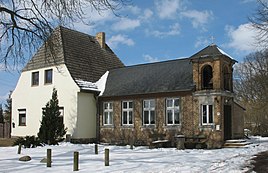
Former school in Klevesche houses with a bell tower
|
|
Klevesche Häuser is a district of the community of Löwenberger Land in the north of Brandenburg . The village was laid out in the 17th century by Reformed colonists from the Duchy of Kleve .
geography
Klevesche Häuser is located in the southeast of the natural area of the Granseer Platte . The district borders in the north on the district Gutengermendorf , in the east on the district Häsen and in the south and west on the district Neuhäsen .
history
Klevesche Häuser was built after 1651 as a colonist village on a part of the desert field of Häsen. Jobst von Hertefeld , which the region as part of the basic rule to Liebenberg belonged there moved Reformed immigrants from the Duchy of Cleves on.
In 1900 the village formed a rural community with an area of 199 hectares in the Ruppin district of the Brandenburg province . On January 1, 1938 Klevesche houses were in the church harbors incorporated .
On December 31, 1997, Häsen merged with nine other communities to form the new community of Löwenberger Land. Klevesche Häuser is part of the community of Löwenberger Land.
Population development
The following table shows the population development of Klevesche houses between 1875 and 1933 in the territorial status of the respective reference date:
| Deadline | Residents | Remarks |
|---|---|---|
| Dec. 1, 1875 | 114 | census |
| Dec. 1, 1890 | 107 | census |
| Dec. 1, 1910 | 91 | census |
| June 16, 1925 | 96 | census |
| June 16, 1933 | 91 | last census before incorporation |
Web links
Individual evidence
- ^ Brandenburg Viewer. Land surveying and geographic base information Brandenburg , accessed on September 17, 2015 .
- ↑ a b Lieselott Enders : Historical local dictionary for Brandenburg . Part II. Ruppin . Klaus D. Becker, Potsdam 2011, ISBN 978-3-941919-79-2 , pp. 93 f. u. 123 f . ( limited preview in Google Book search).
- ^ Community of Löwenberger Land. In: service.brandenburg.de. State government of Brandenburg , accessed on September 17, 2015 .
- ↑ State Office for Data Processing and Statistics Land Brandenburg (Ed.): Historical municipality directory of the State of Brandenburg 1875 to 2005. Landkreis Oberhavel (= contribution to statistics . Volume 19.7 ). Potsdam 2006 ( statistik-berlin-brandenburg.de [PDF; 300 kB ]).


