Kottmarsdorf
|
Kottmarsdorf
Kottmar municipality
|
|
|---|---|
| Coordinates: 51 ° 1 ′ 45 " N , 14 ° 37 ′ 33" E | |
| Height : | 420 m above sea level NN |
| Area : | 7.93 km² |
| Residents : | 490 (March 31, 2019) |
| Population density : | 62 inhabitants / km² |
| Incorporation : | January 1, 1999 |
| Incorporated into: | Obercunnersdorf |
| Postal code : | 02708 |
| Area code : | 035875 |
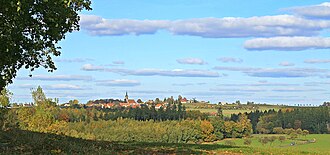
Kottmarsdorf ( Sorb. Chotmarjecy ) is a district of the municipality of Kottmar in the district of Görlitz in southeast Saxony near the border with the Czech Republic . The name can be explained as a village on Kottmar or the Sorbs Chotemer.
geography
Kottmarsdorf is located directly on the connecting road built in 1828 between the cities of Löbau , Neugersdorf and Rumburk . The village extends over the Pfarrberg ( 435 m ); the southernmost part forms the tumult. To the south, in the valley of the bleached water, lies the Kühle Morgen, to the southwest the Harthe and the Raumbusch .
history
On May 1, 1306, Kottmarsdorf, of the forest hoof type, was first mentioned in a document as "Khotdmersdorpp". In 1346 the Kottmarsdorfer local church is mentioned for the first time as a daughter of the Löbauer church. In 1550 Erasmus von Gersdorf was the owner of Kottmarsdorf. The year 1585 went down in history as the great plague year . Other unlucky years were 1607 when the plague broke out again (70 residents died in Kottmarsdorf), 1617 when a great famine ravaged the place and 1633 when the plague broke out again in the village; the bodies were buried at night in the cemetery or at home without any ceremony.
Since January 1, 1999, the originally independent village of Kottmarsdorf has been part of the municipality of Obercunnersdorf . Since January 1, 2013, Kottmarsdorf belongs to the municipality of Kottmar.
Place name forms
1306: Khotdemersdorpp, Khotemersdorff, 1419: Cotmerßdorff, 1430: Kottemersdorff, 1442: Kotmarsdorff, 1564: Kuttmarsdorff, 1657: Cottmarsdorff, 1768: Kottmarsdorf
Administrative affiliation
1777: Bautzen district, 1843: Löbau district court, 1856: Löbau court office , 1875: Löbau district administration , 1952: Löbau district , 1994: Löbau-Zittau district, 2008: Görlitz district
Population development
| year | Residents |
| 1777 | 18 possessed men, 15 gardeners, 36 cottagers |
| 1834 | 811 |
| 1871 | 1,057 |
| 1890 | 977 |
| 1910 | 892 |
| 1925 | 895 |
| 1939 | 863 |
| 1946 | 926 |
| 1950 | 1,045 |
| 1964 | 933 |
| 1990 | 643 |
| 2013 (Feb. 28) | 532 |
societies
Friends of nature and homeland Kottmarsdorf e. V., folk art group Kottmarsdorf e. V., hairdressing museum e. V., Turnverein Kottmarsdorf e. V.
Attractions
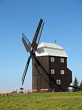
- fully functional, listed Kottmarsdorfer post mill (built in 1843 on the 435 m high Pfarrberg and in operation until 1943)
- Baroque church (first mentioned in a document in 1346 and built in its current form in 1736, expanded by a 50 m high church tower in 1854)
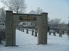
- Honor cemetery for fallen Russian soldiers on the main street
- Hairdressing Museum (opened November 11, 2000), now closed
- Heimatmuseum im Mühlenhaus (Heimatstube with changing exhibitions)
Sources and further reading
literature
- Between Strohmberg, Czorneboh and Kottmar (= values of our homeland . Volume 24). 1st edition. Akademie Verlag, Berlin 1974.
- Cornelius Gurlitt : Kottmarsdorf. In: Descriptive representation of the older architectural and art monuments of the Kingdom of Saxony. 34. Issue: Official Authority Löbau . CC Meinhold, Dresden 1910, p. 276.
Web links
Individual evidence
- ↑ Numbers and facts - population figures. Kottmar municipality, accessed on July 31, 2019 .
- ↑ StBA Area: changes from 01.01. until December 31, 1999
- ↑ a b c Kottmarsdorf in the digital historical place directory of Saxony
- ^ Database of cemeteries in Saxony


