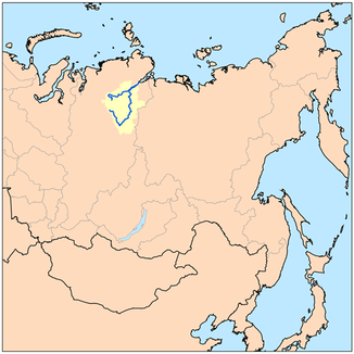
Kotui
|
Kotui Котуй |
||
|
The Kotui as the right, southern source river of the Chatanga |
||
| Data | ||
| Water code | RU : 17040400112117600006917 | |
| location | Krasnoyarsk Region ( Russia ) | |
| River system | Chatanga | |
| Drain over | Chatanga → Arctic Ocean | |
| source | near Mount Kamen in the Putorana Mountains 69 ° 4 ′ 13 ″ N , 94 ° 52 ′ 27 ″ E |
|
| muzzle | near Kresty , union with Cheta to Chatanga Coordinates: 71 ° 54 ′ 56 " N , 102 ° 6 ′ 10" E 71 ° 54 ′ 56 " N , 102 ° 6 ′ 10" E
|
|
| length | 1409 km | |
| Catchment area | 176,000 km² | |
| Left tributaries | Tschangada , Tukalan , Sikasjan | |
| Right tributaries | Moijero , Kotuikan , Erietschka | |
| Flowing lakes | Kharpicha , Lake Djupkun | |
The Kotui ( Russian Котуй ) is 1,409 km long, right-side and south-eastern source river of Khatanga in northern Siberia ( Russia , Asia ) and runs in the former Autonomous District Taimyr in the north of the Krasnoyarsk region .
course
The Kotui rises a little north of the Arctic Circle in the practically uninhabited Putorana Mountains , the north-western part of the Central Siberian Mountains . Its source is in the former Evenk Autonomous Okrug on the border with the former Taimyr Autonomous Okrug on a mountain ( 1510 m ) about 10 km southwest of the 1701 m high Kamen (highest mountain in the range ). Initially, the Kotui flows south-eastwards through the northern part of the mountain range, first passing through Lake Kharpitscha and then through Lake Djupkun . A little later it turns to the northeast and takes in the waters of the Moijero . Finally he joins much further north in the south of the Taimyr peninsula located Taimyrsenke in settling Kresty , about 15 km southwest of the village Chatanga located, with the Cheta to Khatanga. The latter flows further northeast into the Laptev Sea , a marginal sea of the Arctic Ocean .
Ice drift
The kotui is frozen from late September / early October to late May / early June.
Individual evidence
- ↑ a b Article Kotui in the Great Soviet Encyclopedia (BSE) , 3rd edition 1969–1978 (Russian)
- ↑ Chatanga (Kotui, Seisi) in the State Water Register of the Russian Federation (Russian)


