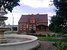
Kowalów (Rzepin)
| Kowalów | ||
|---|---|---|

|
|
|
| Basic data | ||
| State : | Poland | |
| Voivodeship : | Lebus | |
| Powiat : | Slubice | |
| Gmina : | Rzepin | |
| Geographic location : | 52 ° 25 ' N , 14 ° 47' E | |
| Residents : | 911 (December 31, 2015) | |
| Postal code : | 69-110 | |
| Telephone code : | (+48) 95 | |
| License plate : | FSL | |
| Economy and Transport | ||
| Street : | Frankfurt (Oder) - Ośno Lubuskie | |
| Rail route : | Wroclaw-Szczecin | |
| Next international airport : | Poznan-Ławica | |
Kowalów (German Kohlow ) is a village in the Polish voivodeship of Lubusz , Powiat Słubicki .
Geographical location
Kowalów (Kohlow) is located in the historic Neumark region , 9.5 kilometers southwest of the city of Ośno Lubuskie (Drossen) and 9.5 kilometers northwest of the city of Rzepin (Reppen).
history
In 1360 the citizens Kuno Duchtemygut was Drossen with several Bauerhufen in the village Kowl , Caul invested or Kaul; In 1423 the village name Cawl is used, in 1461 Kauwel . In the village, which had belonged to a manor until the 19th century, there was a water mill . This watermill appears in documents under the names Lubensche Mühle , Mühle am Plysich and Buschmühle ; it was known under the latter name until modern times.
In the course of the centuries, several families took turns in the ownership of the manor with a watermill, until the Prussian major a. D. Kaspar Eduard Theodor Wilhelm von Kaphengst bought Lieutenant Döring for 53,400 thalers . A castle-like mansion belonged to the manor. The estate was still owned by the Kaphengst family in the 20th century; Axel von Kaphengst, a member of the Reichstag , owned it until his death in 1913 . During World War II, it was owned by Karl Erich von Kaphengst, who died as a front soldier on February 6, 1945 near Reppen when the Soviet Army marched in.
Until 1945 Kohlow belonged to the district Weststernberg in the administrative district of Frankfurt of the province of Brandenburg .
Towards the end of the Second World War , the region with Kohlow was captured by the Red Army in February 1945 . Kohlow Castle burned down during the fighting. A Soviet headquarters was established in the parsonage of Kohlow. When the region was placed under Polish administration after the end of the war, the administration moved into the rectory. As early as June 1945, one month before the start of the Potsdam Conference , the expulsion of the residents who had returned to Kohlow after the fighting had ceased began. It was carried out with the help of units of the II Polish Army . Kohlow received the Polish name Kowalów . In the following period the village was repopulated.
Population numbers
- 1858: 432
- 1933: 589
- 1939: 514
- 2015: 911
Village church
The village church was built in the 13th century. There are three checkerboard pieces on it . In 1803 the church burned down. It was rebuilt in 1821 for the evangelical community of Kohlow and embellished in 1854. The patronage of the church was exercised by the evangelical landowners Kaphengst family in the 19th century.
In the 1990s the church was renovated.
Personalities
- Rüdiger vom Bruch (1944–2017), science historian
- Axel von Kaphengst (1870–1913), landowner on Kohlow, MdR
literature
- Siegmund Wilhelm Wohlbrück : History of the former diocese of Lebus and the country of this taking . Volume 3, Berlin 1832, pp. 488-490.
- Heinrich Berghaus : Land book of the Mark Brandenburg and the Markgrafenthums Nieder-Lausitz . Volume 3, Brandenburg 1856, pp. 284-285.
- W. Riehl and J. Scheu (eds.): Berlin and the Mark Brandenburg with the Margraviate Nieder-Lausitz in their history and in their present existence . Berlin 1861, p. 500.
- Heinz W. Linke: Rittergutsdörfer - Kohlow, Zerbow, Schmagorei, Lieben . Verlag BoD, Norderstedt 2013, ISBN 978-3-8482-6786-6 ( limited preview ).
Web links
Individual evidence
- ↑ a b c d e W. Riehl and J. Scheu (eds.): Berlin and the Mark Brandenburg with the Margraviate Nieder-Lausitz in their history and in their present existence . Berlin 1861, p. 500
- ↑ a b Linke (2013), pp. 128–129.
- ↑ a b Linke (2013), pp. 179–180.
- ^ A b Michael Rademacher: German administrative history from the unification of the empire in 1871 to the reunification in 1990. weststernberg.html. (Online material for the dissertation, Osnabrück 2006).
- ↑ Statystyka Gminy Rzepin (as of December 31 , 2015 ) , Urząd Miasta i Gminy Rzepin, December 2015, Rzepin.
- ↑ Checkerboard stones at field stone churches
- ↑ Linke (2013), pp. 141–142.


