Lubusz Voivodeship
|
|||
|---|---|---|---|
| map | |||
| Coat of arms and logo | |||

|

|
||
| Basic data | |||
| Seat of the voivod: | Gorzów Wielkopolski (Landsberg on the Warta) | ||
| Seat of Parliament: | Zielona Góra (Grünberg) | ||
| Voivode : | Jerzy Ostrouch | ||
| Voivodeship Marshal : | Elżbieta Polak | ||
| Biggest town: | Zielona Góra (Grünberg) | ||
| ISO 3166-2 : | PL-08 | ||
| Residents : | 1,013,031 (June 30, 2019) | ||
| Population density : | 72 inhabitants per km² | ||
| Unemployment rate : | 15.9% (December 2009) | ||
| License plate : | F. | ||
| geography | |||
| Area : | 13,988 km² | ||
| - of which country: | ? km² | ||
| - of which water: | ? km² | ||
| Expansion: | North-South: up to 171 km West-East: up to 124 km |
||
| The highest point: | 227 m | ||
| Deepest point: | ? m | ||
| Landscape structure | |||
| Forests: | 49.4% | ||
| Waters: | ? % | ||
| Agriculture: | 36.6% | ||
| Other: | ? % | ||
| Administrative division | |||
| Independent cities : | 2 | ||
| Counties : | 12 | ||
| Municipalities : | 82 | ||
The Lubusz Voivodeship ( Polish województwo lubuskie ) is one of the 16 voivodeships into which the Republic of Poland is divided. It borders in the west on the German states of Brandenburg and Saxony , in the east on Greater Poland and essentially comprises the former Brandenburg Neumark (Ostbrandenburg) as well as small parts of the northern Lower Silesia , the eastern Lower Lusatia and parts of the former border march Posen-West Prussia . The capitals of the voivodeship are Gorzów Wielkopolski (Landsberg an der Warthe) as the seat of the voivode appointed by the central government , who is responsible for the administration of the finances allocated centrally from Warsaw, for the interior department and the police, and Zielona Góra (Grünberg) as the seat of the Voivodeship Marshal, his government and parliament (Sejmik) .
history
The naming of the province refers to the historical, both sides of the Oder preferred country Lebus . The city of Lebus is located on the western bank of the Oder in Germany and was the seat of Polish princes and bishops from the time it was taken over by Bolesław Chrobry until the middle of the 13th century. After that, most of today's voivodeship belonged to the Mark Brandenburg until 1945 . The voivodship was created in 1999 as part of the administrative reform from the union of the voivodeships Gorzów Wielkopolski (Landsberg an der Warthe) , Zielona Góra (Grünberg) and a small part of the Leszno (Lissa) voivodeship .
coat of arms
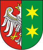
Description : Split in red and green, at the front of the split a gold-crowned, gold-framed and reinforced silver eagle covered with golden clover stems and at the back two golden six-pointed stars on stakes .
Administrative division
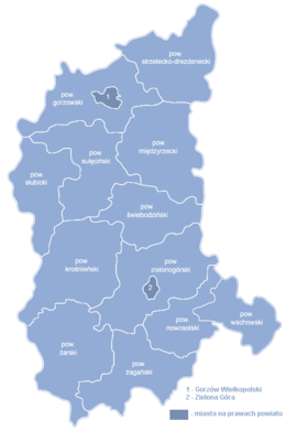
The Lubusz Voivodeship is divided into twelve administrative districts, with the provincial capitals Gorzów Wielkopolski (Gorzów Wlkp.) And Zielona Góra remaining independent. They themselves do not belong to the districts named after them.
One district cities
-
 Gorzów Wielkopolski (Landsberg ad Warthe) 123,691; 86 km²
 -
 Zielona Góra (Grünberg) 140,874; 58 km²
Counties
|
|
|
(Population and area on June 30, 2019)
| Counties | Greatest | Smallest |
|---|---|---|
| area-wise | Powiat Zielonogórski | Powiat Wschowski |
| in terms of population | Powiat Żarski | Powiat Sulęciński |
geography
Biggest cities
The two cities of Zielona Góra and Gorzów are the only large cities in Lebus with around 140,000 and 120,000 inhabitants respectively. The following cities have just a third of this population.
| city | German name | Residents June 30, 2019 |
|---|---|---|
|
|
Grünberg in Silesia | 140.874 |
|
|
Landsberg on the Warta | 123.691 |
|
|
New salt on the Oder | 38,763 |
|
|
Sorau | 37.502 |
|
|
Sagan | 25,731 |
|
|
Schwiebus | 21,736 |
|
|
Meseritz | 17,994 |
|
|
Küstrin | 17,778 |
|
|
Züllichau | 16,831 |
|
|
Frankfurt-Dammvorstadt | 16,705 |
|
|
Guben | 16,619 |
See also: List of cities in the Lubusz Voivodeship
Neighboring voivodeships
| West Pomeranian Voivodeship | ||
|
Brandenburg Germany |

|
Greater Poland Voivodeship |
|
Saxony Germany |
Lower Silesian Voivodeship |
Rivers
The area of the voivodeship belongs entirely to the Oder catchment area.
- Odra (Or)
economy
In comparison with the gross domestic product of the European Union in terms of purchasing power standards , the voivodeship achieved an index of 57 in 2015 (EU-28 = 100). The unemployment rate in 2004 was 23.2%. By December 2009 it had dropped to 15.9 percent.
With a value of 0.820, Lebus ranks 15th among the 16 Voivodships in Poland in the Human Development Index .
traffic
shipping
Inland waterways:
- Or,
- Warta,
- Networks,
- Lusatian Neisse from Guben .
railroad
The railway lines Berlin - Warsaw , Szczecin - Wrocław and Szczecin - Poznań run through the voivodeship . The former Prussian Eastern Railway is only of regional importance in the route Kostrzyn nad Odrą - Gorzów Wielkopolski - Krzyż Wielkopolski .
The railway network is 985 kilometers long, 329 kilometers of which are electrified.
Street
The main traffic axis of the voivodeship, to which the two capitals are connected, is the European route 65 (Polish national route 3 ), which connects Scandinavia with Southeastern Europe .
The important European route 30 (Polish state road 2 ) runs right through the middle of the voivodeship from Cork in the Republic of Ireland via Great Britain , the Netherlands and Germany (including Berlin ) to Warsaw and Eastern Europe ( Minsk - Moscow ), to which neither of the two largest cities is directly connected . The city of Świebodzin is the most important traffic junction in the region, where the two European highways cross.
The road network has a length of around 8,000 kilometers.
Web links
- Marshal's Office of the Voivodeship (Polish)
- Voivodeship Office (Polish)
- Fortress front Oder-Warthe-Bogen, Burschener loop
Footnotes
- ^ Website of the Lubusz Voivodeship, Vojewoda Lubuski , accessed on December 10, 2013
- ↑ population. Size and Structure by Territorial Division. As of June 30, 2019. Główny Urząd Statystyczny (GUS) (PDF files; 0.99 MiB), accessed December 24, 2019 .
- ↑ population. Size and Structure by Territorial Division. As of June 30, 2019. Główny Urząd Statystyczny (GUS) (PDF files; 0.99 MiB), accessed December 24, 2019 .
- ↑ Eurostat. Retrieved April 15, 2018 .
- ↑ http://www.eds-destatis.de/en/downloads/sif/dn_06_01.pdf ( Memento from September 27, 2007 in the Internet Archive )
- ↑ Central Statistics Office of Poland (CIS), Bezrobotni oraz stopa bezrobocia wg województw, grudzień 2009 , February 3, 2010 ( Memento from April 2, 2015 in the Internet Archive )
- ^ Sub-national HDI - Area Database - Global Data Lab. Retrieved August 12, 2018 .
Coordinates: 52 ° 12 ' N , 15 ° 21' E


