Vinohrady
| Vinohrady | |||
|---|---|---|---|
|
|||
| Basic data | |||
| State : |
|
||
| Region : | Hlavní město Praha | ||
| Municipality : | Praha | ||
| Administrative district : | Prague 2 , Prague 3 , Prague 10 , Prague 1 , Prague 4 | ||
| Area : | 379 ha | ||
| Geographic location : | 50 ° 5 ' N , 14 ° 27' E | ||
| Residents : | 50,782 (December 31, 2015) | ||

Vinohrady (until 1960 Královské Vinohrady , German Royal Vineyards ) is a district in the Czech capital Prague , east of the New Town .
In 1922 the city of Královské Vinohrady was incorporated into Prague. During the territorial reform of 1960, the district was allocated to a total of five districts: the largest part was assigned to Prague 2. The elongated eastern tip was split lengthways between Prague 3 and Prague 10. Two smaller areas fell to Prague 1 and Prague 4, respectively.
history
The name Vinohrady is derived from medieval vineyards that were located on the south-western slopes behind the city gates, above the Rossmarkt (Koňský trh), renamed Wenceslas Square in 1848 .
The village of Weinberge / Hory Viničné was established in 1788. In 1849 the village became independent, in 1867 the municipality was given the new name Royal Vineyards / Královská Vinohradská obec. From 1868 Royal Vineyards belonged to the Karolinenthal district . In 1875, Royal Vineyards was divided into two parishes; the northeastern part was named Vinohrady I and two years later it was renamed Žižkov , the southwestern part became the municipality of Vinohrady II, which was named Royal Vineyards / Královské Vinohrady since 1877. In 1878 the Royal Vineyards judicial district was formed. The Austrian monarchy wanted to prevent the centralization of the city of Prague and in 1879 elevated Královské Vinohrady to a royal city . In 1884 the Royal Vineyards District was formed.
Since the middle of the 19th century, houses for the upper middle class have been built in the district in the direction of today's National Museum . After the 1920s, urbanization took place in the direction of Ohrada and Malešice . From 1892 to 1894, the Vinohrady carousel stood in Vinohrady , which later moved to Letná Park. In 1897 Vinohrady was connected to the network of electric trams, in 1978 and 1980 to that of the metro .
In 1913 the city had 84,000 inhabitants. At the census of 1921, 83,367 people lived in the 1750 houses of Královské Vinohrady, including 74,180 Czechs, 5567 Germans and 1011 Jews. After Prague and Brno, Královské Vinohrady was the third largest city in what is now the Czech Republic in 1922 with 90,000 inhabitants. In the same year it was incorporated into the capital with other villages and towns in the area. Today this district is one of the luxury residential areas of Prague due to the horrendous rents. The center of the district is the Square of Peace (Náměstí Míru), Vinohradská třída Street and the Riegrovy Sady Park. In 1991 the district had 65,752 inhabitants. In 2001, Vinohrady consisted of 2,317 apartment buildings in which 54,516 people lived. The proportion of foreigners living here, not least Westerners, is now relatively high.
Transport links
As early as 1897, a tram line was built in Vinohrady that connected the National Museum with Flora.
Today, Vinohrady is connected to the city center and other parts of the city by underground lines A and C and tram lines 4, 6, 10, 11, 16, 22 and 23.
Apart from line 135, bus transport only plays a subordinate role in local public transport in this district.
Significant buildings
theatre
- Státní opera Praha (Prague State Opera), previously Smetanovo divadlo (1886–1887)
- Divadlo na Vinohradech (1905–1909)
Public buildings
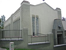
- Czech Radio Building (1929–1931)
- Central Station (1901–1909, Kaisers Franz Josefs-Bahnhof, Wilson-Bahnhof)
- People's House (Národní dům) (1893–1894)
- Market hall (Vinohradská tržnice) (1902)
- Water tower (Vinohradská vodárenská věž) (1891)
Cemeteries and crematoria
- Vinohrady cemetery (1885) with the graves of Presidents Hácha and Havel
- Strašnice crematorium (1929–1932) on the site of the Vinohrady cemetery
Chapels and churches
- Chapel of the Holy Family ( Kaple Sv. Rodiny ) (1755)
- Hus College ( Husův sbor ) (1932–1935)
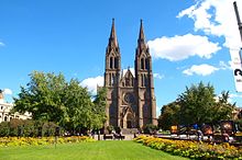
- Church of St. Ludmila ( Kostel Sv. Ludmily ) (1888–1893)
- Church of the Most Sacred Heart of the Lord ( Kostel nejsvětějšího srdce Páně ) (1928–1932)
Parks and gardens

- Riegrovy sady (1904–1908), named after František Ladislav Rieger
- Havlíčkovy sady
- Bezručovy sady, named after Petr Bezruč
- Sady Svatopluka Čecha, named after Svatopluk Čech
Private houses, villas
- Semi-detached house of the Čapek brothers (Dvojdům bratří Čapků) (1928–1929)
- Villa Gröbe (Gröbova vila) (1871–1888)
- Kotěrova vila (1908–1909)
- Laichterův dům (1908–1909)
- Schnirchův dům (1875)
- Šalounova vila (1908–1909): home and studio of the sculptor Ladislav Šaloun , who created the Hus monument on the Old Town Square .
Web links
- official website (Czech)


