Kalocsa district
| circle Kalocsai járás
Kalocsa |
|
|---|---|
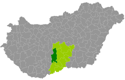
 Location of the district in Hungary |
|
| Basic data | |
| Country | Hungary |
| County | Bács-Kiskun |
| Seat | Kalocsa |
| surface | 1,062.3 km² |
| Residents | 49,115 (January 1, 2016) |
| density | 46 inhabitants per km² |
The county Kalocsa (Hungarian Kalocsai járás ) is a district in the west of Bács-Kiskun . It was created as part of the administrative reform at the beginning of 2013 as the successor to the disbanded small area Kalocsa (Hungarian Kalocsai kistérség ) and a municipality from the small area Kunszentmiklós (Hungarian Kunszentmiklósi kistérség ). The district borders on Tolna County to the west . District seat is the largest city Kalocsa .
Community overview
| local community | status | Origin small area |
population | surface | Population density (inh / km²) |
||
|---|---|---|---|---|---|---|---|
| October 01, 2011 | 01/01/2013 | 01/01/2016 | |||||
| Bátya | local community | Kalocsa | 2,094 | 2,060 | 1.997 | 33.86 | 59.0 |
| Drágszél | local community | Kalocsa | 311 | 326 | 309 | 12.59 | 24.5 |
| Dunapataj | Large community | Kalocsa | 3,172 | 3,180 | 3,057 | 90.47 | 33.8 |
| Dunaszentbenedek | local community | Kalocsa | 866 | 865 | 809 | 23.24 | 34.8 |
| Dunatetétlen | local community | Kalocsa | 532 | 529 | 516 | 43.19 | 11.9 |
| Dusnok | local community | Kalocsa | 2,934 | 2,958 | 2,809 | 57.47 | 48.9 |
| Fajsz | local community | Kalocsa | 1,709 | 1,712 | 1,655 | 31.99 | 51.7 |
| Foktő | local community | Kalocsa | 1,586 | 1,628 | 1,568 | 31.46 | 49.8 |
| Géderlak | local community | Kalocsa | 1,015 | 1,020 | 981 | 18.74 | 52.3 |
| Hajós | city | Kalocsa | 3,104 | 3.115 | 3,013 | 89.92 | 33.5 |
| Harta | Large community | Kalocsa | 3,936 | 3,417 | 3,285 | 129.68 | 25.3 |
| Homokmégy | község | Kalocsa | 1,366 | 1,398 | 1,292 | 70.32 | 18.4 |
| Kalocsa | city | Kalocsa | 17,142 | 16,552 | 15,986 | 53.18 | 300.6 |
| Miske | local community | Kalocsa | 1,711 | 1,722 | 1,646 | 42.27 | 38.9 |
| Ordas | local community | Kalocsa | 447 | 420 | 420 | 16.52 | 25.4 |
| Öregcsertő | local community | Kalocsa | 807 | 809 | 751 | 43.06 | 17.4 |
| Solt | city | Kalocsa | 7,019 | 6,488 | 6.312 | 132.67 | 47.6 |
| Szakmár | local community | Kalocsa | 1,205 | 1,237 | 1,202 | 74.64 | 16.1 |
| Újsolt | local community | Kunszentmiklós | 158 | 181 | 200 | 32.98 | 6.1 |
| Újtelek | local community | Kalocsa | 357 | 355 | 349 | 9.56 | 36.5 |
| Uszód | local community | Kalocsa | 1,026 | 1,056 | 958 | 24.46 | 39.2 |
| Kalocsa district | 52,497 | 51,028 | 49,115 | 1,062.27 | 46.2 | ||
swell
PDF and XLS files:
2011 Census ( Census )
2013 :; 2016:
Trivia
The following municipalities in the middle part of the district consist of two parts, i. H. a larger and a smaller part of the municipality, which are separated by another municipality: Fajsz, Foktő and Géderlak. The district town of Kalocsa also has an exclave within the municipality of Foktő, near the border with western Tolna county.
Individual evidence
- ↑ KSH: 2011. Évi Népszámlálás. In: 3. Területi adatok. KSH, accessed on December 24, 2016 (Hungarian, also via: http://www.terezvaros.hu/testuleti/nepsz2011-3/pdf/nepsz2011_03_03.pdf ).
- ↑ KSH: Regional data - Bács-Kiskun county. KSH, accessed on December 24, 2016 (English, 4th Data on Localities).
- ↑ KSH: Gazetteer of Hungary, 1st January, 2013. KSH, accessed March 8, 2017 (Hungarian / English).
- ↑ KSH: Gazetteer of Hungary, 1st January, 2016. KSH, accessed March 8, 2017 (Hungarian / English).