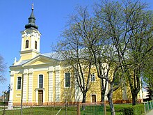
Hajós
| Hajós | ||||
|
||||
| Basic data | ||||
|---|---|---|---|---|
| State : | Hungary | |||
| Region : | Southern Great Plain | |||
| County : | Bács-Kiskun | |||
| Small area until December 31, 2012 : | Kalocsa | |||
| District since 1.1.2013 : | Kalocsa | |||
| Coordinates : | 46 ° 24 ' N , 19 ° 7' E | |||
| Area : | 89.92 km² | |||
| Residents : | 3,160 (Jan 1, 2011) | |||
| Population density : | 35 inhabitants per km² | |||
| Telephone code : | (+36) 78 | |||
| Postal code : | 6344 | |||
| KSH kódja: | 18759 | |||
| Structure and administration (as of 2012) | ||||
| Community type : | city | |||
| Mayoress : | Erzsébet Estók Mihályné Szalczer | |||
| Postal address : | Rákóczi utca 12. 6344 Hajos |
|||
| Website : | ||||
| (Source: A Magyar Köztársaság helységnévkönyve 2011. január 1st at Központi statisztikai hivatal ) | ||||
Hajós ( dt. Hajosch ) is a town in County Bács-Kiskun in southern Hungary .
history
The name Hajós is derived from hajó and means boat or ship . In the Middle Ages, the place was surrounded by a significantly larger amount of water than it is today. The place lies on an elevation of a flood plain of the former river bed of the Danube.
Hajós was destroyed during the Turkish Wars.
In 1722 the Archbishop of Kalocsa founded a Swabian village on the site , with the support of German immigrants from Württemberg . The place was granted market rights in 1756 .
politics
Parish partnership
- A partnership with the German municipality of Hirrlingen has existed since 1982
- Lengenfeld in Lower Austria
Culture
There is a strong wine culture around Hajós . There are around 1200 wine cellars in the village . The St. Urban Wine Festival that takes place at the end of May attracts crowds of visitors every year.


