Kronberg (Altmelon municipality)
|
Kronberg ( Rotte ) locality |
||
|---|---|---|
|
|
||
| Basic data | ||
| Pole. District , state | Zwettl (ZT), Lower Austria | |
| Judicial district | Zwettl | |
| Pole. local community | Altmelon ( KG Kleinpertenschlag) | |
| Coordinates | 48 ° 27 '0 " N , 14 ° 58' 0" E | |
| height | 820 m above sea level A. | |
| Residents of the village | 45 (January 1, 2020) | |
| Building status | 18 (2001) | |
| Statistical identification | ||
| Locality code | 06925 | |
| Counting district / district | Großpertenschlag (32519 000) | |
| Source: STAT : index of places ; BEV : GEONAM ; NÖGIS | ||
Kronberg is a district of the cadastral municipality of Kleinpertenschlag in the market town of Altmelon in the Zwettl district in northwest Lower Austria , the so-called Waldviertel .
geography
Kronberg is located in the Waldviertel highlands, the hilly landscape is criss-crossed by large forest areas. There are also numerous granite blocks scattered around the landscape. Kronberg is located on the border between Lower Austria and Upper Austria , due to its proximity to the Upper Austrian municipality of St. Georgen am Walde , the households in Kronberg have an Upper Austrian postal address. There is also a school and parish affiliation to St. Georgen. Marchstein in the municipality of Altmelon and Ottenschlag and Linden in the municipality of St. Georgen am Walde are the direct neighbors of Kronberg.
Culture and sights
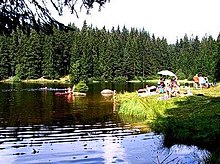
Klaus pond
The Klausteich, a former alluvial pond, is used today as a fishing and bathing pond. It is on the border with Upper Austria and can be reached via a short footpath. The water is clean, but has a clear brown color due to the high humic content. In 1934 the dam broke and the Nussbach valley was flooded. Fortunately, people were not harmed, but one of the stables was swept away by the masses of water.
Iron picture
According to the legend, the chapel "zum Eiserner Bild" is due to the miraculous rescue of a stray wanderer who, out of gratitude, had a picture painted in honor of the divine Trinity . On Trinity Sunday, the Sunday after Pentecost , there is a Kirtag at the Iron Image, to which people from all over the region like to come.
Midsummer tree
Kronberg used to own a solstice tree, which had a special feature: a bottle of Pentecost, Easter and Epiphany water was hung on it. The old custom was to stop lightning strikes. The tree itself, however, represents a symbol of life, it stands for strength and vitality. A custom that has been forgotten in recent years and is no longer practiced.
Midsummer bonfire
This custom too was almost forgotten. But in 2006, after a long break, the committed organizers managed to hold this festival, which was very positively received by the population and led to large participation. A solstice fire was held again in 2008.
Sports
- numerous hiking and mountain bike trails
- In September 2007 Kronberg was co-organizer of the extreme mountain bike spectacle Granitbeisser
- any kind of outdoor sports
traffic
A well-developed supply route through Kronberg connects the federal highways B119 ( Greiner Straße ) and B119a.


