
Kunigundenweg
| Kunigundenweg | |
|---|---|
 Kundigundenweg logo |
|
| Data | |
| length | 110 km |
| location |
Bavaria
|
| Starting point |
Aub 49 ° 31 '32.1 " N , 10 ° 2' 26.3" E |
| Target point |
Bamberg 49 ° 53 '39 " N , 10 ° 52' 30.3" E |
| Type | trail |
The Kunigundenweg is a historic connecting route and today's Benedictine hiking trail from the 9th century. Its name refers to St. Kunigunde, who went on horseback riding in her lands here. It is 110 km long and divided into 5 stages.
history
St. Kunigunde used this path, also known as the "donkey path" or "grass path", for rides in their lands. Over the past centuries, many tourists have made pilgrimages and wandered to the tomb of St. Imperial couple in Bamberg Cathedral. Other shrines were usually visited, and especially those churches dedicated to St. Kunigund.
legend
According to a legend, Kunigunde had three veils fly in Bamberg in order to build chapels at the point where they were found. On the church wall of the Kunigunden chapel in Buch near Aub, the starting point of the hiking trail, a 1000-year-old linden tree grows, in whose crown one of the veils is said to have stuck.
course
The path begins a few kilometers east of the village of Aub . The path then passes in an easterly direction through the towns of Hemmersheim , Gollhofen , Ippesheim and then, like the parallel Steigerwald-Panormaweg, crosses the two mountains Hoher Landsberg and Scheinberg - thus also the highest points of the path. He also crosses the Iffigheimer Berg , where there is a well-known observation tower. The path then goes through a longer forest area. After a few more kilometers, the Kundigundenweg reaches Markt Bibart . The hiking trail, which now runs in a north-easterly direction, then reaches Scheinfeld , where the Schwarzenberg Castle is one of the major sights of the tour. Then he passes the Scharfeneck ruin , which is near Oberscheinfeld . After a few more kilometers the path reaches the Burgstall Schloss Pank . The hiking trail then runs parallel to the Rimbach and Haslach streams and then reaches Burghaslach and Schlüsselfeld . Then the hiking trail crosses Burgebrach and Walsdorf and after a total of 110 km it comes to an end near Bamberg .
Stages
| stage | From | To | length
in km |
|---|---|---|---|
| 1. | Aub | Bull Home | 20.9 |
| 2. | Bull Home | Scheinfeld | 22.0 |
| 3. | Scheinfeld | Burghaslach | 18.9 |
| 4th | Burghaslach | Burgebrach | 21.5 |
| 5. | Burgebrach | Bamberg | 13.5 |
Source:
Places on the hiking trail
- Aub
- Hemmersheim
- Gollhofen
- Ippesheim
- Bibart market
- Scheinfeld
- Rosenbirkach
- Oberrimbach
- Kirchrimbach
- Unterrimbach
- Burghaslach
- Key field
- Burgebrach
- Walsdorf
- Bamberg
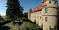
Attractions

Schwarzenberg Castle

Burghaslach Castle
Frankenberg Castle

Kunigunden chapel

Bamberg World Heritage

Hohenlandsberg castle ruins

Scharfeneck ruins


See also
Individual evidence
- ↑ Kunigundenweg. Retrieved March 29, 2020 .
- ↑ Kunigundenweg. Retrieved March 29, 2020 (American English).
- ↑ Kunigundenweg. Retrieved March 29, 2020 .
- ^ Kunigunden chapel book. Retrieved March 29, 2020 .
- ^ BayernAtlas. Retrieved March 29, 2020 .
- ↑ Sven: Kunigundenweg stage 5. Accessed on March 29, 2020 (German).