
Steigerwald Panorama Trail
| Steigerwald Panorama Trail | |
|---|---|
 Steigerwald-Panoramaweg logo |
|
| Data | |
| length | 161 km |
| location |
Bavaria
|
| Markers | Steigerwald Panorama Trail |
| Starting point |
Bad Windsheim 49 ° 30 ′ 50 ″ N , 10 ° 24 ′ 59 ″ E |
| Target point |
Bamberg 49 ° 53 '27 " N , 10 ° 51' 53" E |
| Type | trail |
| Height difference | approx. 271 m |
| The highest point | 499 m Scheinberg |
| Lowest point | 228 m Steigerwald foreland |
| Level of difficulty | medium |
| season | all year round |
| particularities | certified as a quality path for Wanderable Germany; |
The Steigerwald-Panoramaweg is a certified hiking trail in Franconia that was redesigned in September 2009 and is around 161 kilometers long . The trail is divided into 9 stages.
course
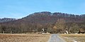
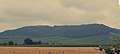
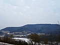
The hiking trail begins near the Frankentherme in Bad Windsheim. The panorama path then runs in a north-easterly direction and passes the Gräfholz forest. The path then crosses the Tief brook in Oberntief , a tributary of the Aisch, and then crosses a larger forest area in a westerly direction. After a few kilometers, the hiking trail with the Hohen Landsberg and the Scheinberg reaches its highest points. From there you have a good view of the Franconian wine-growing region , similar to that from Bullenheimer Berg . Then the panorama path crosses the Schwanberg with the Schwanberg Castle . The path then runs in an easterly direction through a forest area, before reaching another well-known destination, the Friedrichsberg . Then he crosses the Schönberg and passes the village of Gräfenneuses , where the Glößberg lookout is located. After a few more kilometers, the Steigerwald Panorama Trail reaches the wine village of Handthal , where the Stollberg, the highest vineyard in Franconia, is the Steigerwald Center. Then it runs in a northerly direction and reaches another major highlight of the tour with the treetop path in Ebrach.
The path that continues along the Steigerwald west edge reaches the town of Michelau in the Steigerwald with the Zabelstein after a few more kilometers . On the mountain there is a tavern, the Zabelstein ruins and a lookout tower. He then crossed the two Knetzberge, Großer- and small Knetzberg that already by the Celts were settled. Then he passes the Ebersberg ruins and the towns of Ober- and Unterschleichach, where one of the few ski lifts in the Steigerwald is located. Then the hiking trail runs south of the Main, past Eltmann towards Bamberg. After 161 km the hiking trail ends in the western part of the city of Bamberg . The highest point is on the 499 meter high Scheinberg and the lowest in the Steigerwald foreland
Stages
| stage | From | To | km |
|---|---|---|---|
| 1. | Bad Windsheim | Herbolzheim | 12.0 |
| 2 | Herbolzheim | Bull Home | 14.2 |
| 3 | Bull Home | Iphofen | 19.5 |
| 4th | Iphofen | Abtswind | 16.4 |
| 5. | Abtswind | Ebrach | 16.4 |
| 6th | Ebrach | Michelau in the Steigerwald | 15.4 |
| 7th | Michelau im
Steigerwald |
Eschenau | 19.0 |
| 8th | Eschenau | Eltmann | 23.7 |
| 9 | Eltmann | Bamberg | 24.7 |
Source:
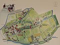
Places on the hiking trail
- Bad Windsheim
- Herbolzheim
- Huettenheim
- Mönchsondheim
- Einersheim market
- Iphofen
- Abtswind
- Castell
- Gräfenneuses
- Small greens
- Ebrach
- Handthal
- Michelau in the Steigerwald
- Prüßberg
- Oberschwappach
- Ebersberg
- Oberschleichach
- Unterschleichach
- Oberaurach
- Eltmann
- Bamberg
Source:
Elevations on the hiking trail
Zabelstein

Stollberg
Schwanberg

Friedrichsberg
Great Knetzberg

Schlossberg

Schoenberg

_.Jpg)


.jpg)
Attractions

Zabelstein castle ruins

Stollberg castle ruins
Stollberg, the highest vineyard in Franconia. There is also a viewing platform on the mountain.

Treetop Walk Ebrach

Unesco World Heritage Bamberg
Open air museum Bad Windsheim

Schwanberg Castle and view of the Franconian vineyards

Kunigunden Chapel Bullenheim

.JPG)


certificate
Since January 2009 the Steigerwald-Panoramaweg has been certified as a “Quality Trail Hikable Germany”.
See also
Individual evidence
- ↑ a b c Steigerwald Panoramaweg. Retrieved March 27, 2020 .
- ↑ static.et4.de: Profile Steigerwald-Panoramaweg. Retrieved March 27, 2020 .
- ^ BayernAtlas. Retrieved March 27, 2020 .
- ↑ Via the panorama path. Retrieved March 27, 2020 .