Kurram
| Kurram | ||
|
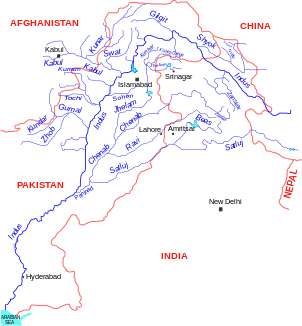
Location of the Kurram in the river system of the Indus |
||
| Data | ||
| location |
Paktia ( Afghanistan ), Federally Administered Tribal Areas , Khyber Pakhtunkhwa , Punjab ( Pakistan ) |
|
| River system | Indus | |
| Drain over | Indus → Indian Ocean | |
| Headwaters | 20 km southeast of Gardez 33 ° 31 ′ 41 ″ N , 69 ° 26 ′ 59 ″ E |
|
| Source height | approx. 3000 m | |
| muzzle |
Indus coordinates: 32 ° 37 ′ 40 " N , 71 ° 21 ′ 37" E 32 ° 37 ′ 40 " N , 71 ° 21 ′ 37" E |
|
| Mouth height | approx. 200 m | |
| Height difference | approx. 2800 m | |
| Bottom slope | approx. 8.8 ‰ | |
| length | approx. 320 km | |
| Right tributaries | Kaitu , Tochi | |
| Medium-sized cities | Thall , Bannu | |
| Small towns | Sadda, Alizai | |
The Kurram is a right tributary of the Indus in Afghanistan and Pakistan .
The Kurram rises 20 km southeast of Gardez in the province of Paktia in the east of Afghanistan . The river cuts through the Safed Koh Mountains in a north-easterly direction and after 80 km crosses the border to Pakistan . The Kurram flows south past the town of Parachinar . The river now flows mainly in a south-easterly direction. It flows through the Kurram Agency , which forms part of the tribal areas under federal administration , and passes through the towns of Sadda and Alizai. In the province of Khyber Pakhtunkhwa, the Kurram flows through the city of Thall . It then flows a little through the North Waziristan Agency . It cuts through a low mountain range and then picks up the Kaitu from the right. North of Bannu , the river reaches the Indus Plain . It flows past the northern edge of the city of Bannu. In the lower reaches of the Tochi flows into the river from the right. At Isa Khel in the Punjab province , the Kurram finally flows into the Indus on the right-hand side. The Kurram has a length of approx. 320 km.
Kurram Tangi Dam Project
The Kurram Tangi Dam Project is a hydropower and irrigation project in the North Waziristan Agency on Kurram. It includes a 98 m high CFRD dam below the confluence of the Kaitu and an 83.4 MW hydropower plant.
Individual evidence
- ↑ a b WAPDA ( Memento of the original from February 3, 2015 in the Internet Archive ) Info: The archive link was automatically inserted and not yet checked. Please check the original and archive link according to the instructions and then remove this notice.
