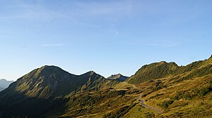
Öffelspitze (Bregenz Forest Mountains)
| Spoon tip | ||
|---|---|---|
|
Spoon tip and the ridge of the sera, over which the shortest access runs |
||
| height | 1962 m above sea level A. | |
| location | between the municipalities of Laterns , St. Gerold and Blons in Vorarlberg , Austria | |
| Mountains | Walserkamm , Bregenz Forest Mountains | |
| Dominance | 3.9 km → Tälispitze | |
| Notch height | 96 m ↓ Bärenjoch | |
| Coordinates | 47 ° 15 '11 " N , 9 ° 49' 38" E | |
|
|
||
| Development | trail | |
| Normal way | Hiking trail from the Furkajoch over the Sera-Jöchle (1 Sd.), From St. Gerold (4–5 hours) or from Blons (3.5 hours) | |
|
The Walserkamm from the south |
||
|
View from the Portlaalpe to the Furkajoch, the Seraspitze, the Pfrondhorn and in the background the spoon tip |
||
The spoon tip (also: spoon spitz , 1962 m above sea level ) is a mountain in the Walserkamm , part of the Bregenzerwaldgebirge , which is located in the municipal area of Blons , St. Gerold and Laterns . The Furkajoch is about 1600 m, the Pfrondhorn about 1500 m and the Seraspitz about 1300 m as the crow flies. There is a striking summit cross on the summit.
location
The spoon tip is one of the first peaks of the Walserkamm, which stretches in a straight line from east to west to the city of Feldkirch and which is the southernmost chain of the Bregenzerwald Mountains.
It's a prominent, pronounced peak. The vegetation consists of dense grass and some shrubs , heather and fir trees etc.
The Frutz rises to the northwest, about 200 meters as the crow flies below the spoon tip .
Adjacent peaks and notches or Alps
In the northeast, about 1300 m as the crow flies, are the Seraspitz ( 1891 m above sea level ) and the Pfrondhorn ( 1949 m above sea level ), about 1600 m away the Furkajoch ( 1759 m above sea level ) and about 1300 m away the Serajochle ( 1855 m above sea level ). Southwest, about 1000 m away, is the Mutabellaspitze ( 1933 m above sea level ).
All around the spoon tip are different Alps.
hike

The mountain requires surefootedness and a head for heights, very good footwear.
The easiest way to get to the Spoonspitze leads from Blons via Oberblons and the Sentum Alpe to the Spoonspitze (approx. 3.5 hours of walking, approx. 800 m ascent ). There is a bus connection from Blons to Alpe Sentum, which shortens the walking time accordingly. Another path leads from St. Gerold (Gasthaus Kreuz) to Plankenberg on the Salum Maisäß and to the Plansott Alpe, Schäfisalpe to the Sentum Alpe and then to the Spoonspitze (approx. 4-5 walking hours, approx. 1000 m).
The shortest, more exposed path (approx. 1 hour, around 200 m ascent) with the risk of falling in the last part of the path begins at the Furkajoch (see warning notices on the Serjöchle and again on the ridge itself). When walking the path over the ridge from the Furkajoch over the Serajöchle, you have to climb over rocks in some cases, as there is not a continuous hiking trail. To the left and right of the path, the ridge descends very steeply in places. As a rule, this path can only be walked in good weather and not with small children.
cards
- Compass map 1: 50,000, sheet 2 Bregenzerwald - Westallgäu
literature
- Dieter Seibert : Bregenzerwald and Lechquellen Mountains. Alpine Club Guide alpine. 1st edition. Bergverlag Rother, Munich 2008, ISBN 978-3-7633-1095-1 .


