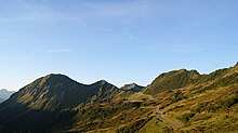
Portlaalpe

The Portlaalpe (also: Alpe Portla ) is located at 1710 m above sea level. A. and is located in the area of the municipality of Damüls . This is an alp for grazing cattle and a piece of land in the same place. The Alpe is about 400 m away from Furkastraße and about 1500 m as the crow flies from Furkajoch . The owner of the Alpe is the agricultural community Übersaxen . It consists of three large alpine buildings. The cultivation period begins annually at the end of June until the first week of September.
history
In a document from 1412, the sale of the alp property on the Alpe Portla of the Feldkirch citizen Jos Rilich to buyers from Übersaxen and Göfis is documented.
In 2003 the Alpe was electrified and in 2011 the water supply was implemented and secured with a spring catchment.
Location and use, geology
The Portlaalpe is located at the westernmost foothills of the Damüls municipality and about 600 m as the crow flies from the Dornbirn municipality and about 850 m from the municipality of Laterns .
The usable forage area of the alp is 183.4 ha . Each year Schwendearbeiten from Alppächter and workers of the agricultural community in hand and clamping services performed for recovering pastures .
In the immediate vicinity of Alpe Portla you can see a striking glacier cut (access road to the Alpe, left side).
tourism
The Portlaalpe is only managed in summer and is the starting point for hikes to the Portlakopf (1905), the Portlahorn (2010), Sünserkopf (2032), the Sünser Spitze (2061), Ragazer Blanken (2051, mountain station of the Ragaz six- person chairlift ), the Hochblanken ( 2068), the Hohen Freschen (2004), Matona (1998) etc. In winter this alp is the starting point for demanding ski tours . See also: Damülser Berge .
The Austrian long-distance hiking trail 01 (also: Nordalpenweg) leads over Faschina , Damüls (1428 m), over the Alpe Portla to Hohen Freschen and from there to Dornbirn (see: From Arlberg to Lake Constance ).
The closest base hut for hikers is the Freschenhaus (1840) under the Hohe Freschen.
Waters
To the east, directly past a stable building of the Alpe, flows a tributary of the Portlabach, which rises about 120 m above from a source at water kilometers (GwKm) 0.605 and joins the main branch at GwKm 1.32 and at GwKm 6.18 (im Portlawald) flows into the Ladritschbach.
Nature reserve
The Portlaalpe used to be its own plant protection area and is now part of the Hohe Kugel - Hoher Freschen −Mellental nature reserve .
Web links
Individual evidence
- ↑ Feldkircher Alp possession then and now , Christoph Volaucnik, city archivist.
- ^ Alpe Portla , website of the municipality of Übersaxen .
- ^ Alpe Portla , website of the municipality of Übersaxen.
- ↑ The hike to the Hoher Freschen and back takes about 5 to 6 hours.
- ↑ § 26 Paragraph 5 of the Vorarlberg Law on Nature Conservation and Landscape Development. Ordinance 39/1969 of the Vorarlberg state government on the protection of alpine plants in the area of Alpe Portla, Damüls (repealed and replaced by ordinance 7/1979).
- ↑ See: Ordinance 7/1979 of the Vorarlberg state government on the nature reserve Hohe Kugel - Hoher Freschen - Mellental in Damüls, Dornbirn, Fraxern, Götzis, Hohenems, Klaus, Koblach, Laterns, Mellau and Viktorsberg.
Coordinates: 47 ° 16 ′ 46.8 " N , 9 ° 50 ′ 22.3" E


