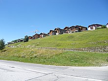
La Rosière (Montvalezan)
Coordinates: 45 ° 37 '38 " N , 6 ° 50' 57" E
La Rosière - Espace San Bernardo is a place and a winter sports area in the southeast of France in the Tarentaise , located on the territory of the municipality Montvalezan in the department of Savoie in the region of Auvergne Rhône-Alpes . At an altitude of 1850 m, it is built on a balcony facing south and offering a panorama over the valley. The ski area is connected to the large Franco-Italian area of Espace San Bernardo .
geography
location
La Rosière is located in the Tarentaise valley and on the French side of the Little Saint Bernard pass road in the Savoie department. Its height varies from 1850 to 2650 m, the ski station is at 1850 m.
Access to the station
By train: Bourg-Saint-Maurice train station from Lyon via Chambéry , Albertville and Moûtiers . Several TGVs arrive there and also serve the mountain resorts of Les Arcs , Tignes and Val-d'Isère . By car: via the N90 from Tarentaise to Bourg-Saint-Maurice, then the D1090, which curves from Séez to the Little Saint Bernard Pass. Note that this road is closed from La Rosière in winter. In summer on the pass road from Courmayeur and the Mont Blanc tunnel or through the Aosta Valley .
history
La Rosière is an old village, the modern spa town, founded at the beginning of the 1950s, has been connected to the municipality of La Thuile in winter since 1984 and forms a contiguous ski area. The villages are connected by two ski lifts via the Little St. Bernard . Compared to its neighboring area Val-d'Isère , La Rosière is relatively small with 150 km of slopes. The ski area of l'Espace San Bernardo (to which La Thuile also belongs) offers all possibilities: Since the beginning of 2008 there are 6 green and 23 blue slopes for beginners and 32 red and 6 black slopes for advanced skiers.
In the 1960s and 1970s, newer, wood-clad Neosavoyard chalets with cubic buildings were built that were based on the basics of traditional Savoyard architecture - wood, stone and lauze (roof shingles made of slate or stone).
A special feature on the higher slopes is the Fort de la Redoute Ruinée , a border fortification that France built in the early 1890s as part of a general border fortification after the loss of Alsace and Lorraine to Germany in 1870. It was heavily reinforced between 1936 and 1940 as part of the Alpin line in anticipation of an invasion from Italy. In June 1940, during the Battle of France at the beginning of World War II , a small force of 47 men resisted multiple attacks from Italy before being allowed to leave with the flag after the armistice . The fort suffered severe damage when French forces tried to retake it towards the end of the war. It is now destroyed and public access to the interior is prohibited for safety reasons.
Cycling race
La Rosière was the destination on the rather short (108 km) 6th stage of the Tour de l'Avenir 2014. The ascent was classified in the first category. The Colombian Miguel Ángel López won this stage ahead of Robert Power who was just behind him in the overall standings. The Tour de l'Avenir came back on stage 5 in 2015 and saw the Frenchman Guillaume Martin win in a breakaway attempt .
In 2018, the Critérium du Dauphiné organized the arrival of the 6th stage in 2018 with the victory of Pello Bilbao in front of the yellow jersey Geraint Thomas .
On July 18, La Rosière was the destination of the 11th stage of the Tour de France 2018 over 108.5 km from Albertville .
Web links
- La Rosière - station de ski Franco-Italienne, enneigement exceptionnel. In: larosiere.net. Retrieved June 28, 2018 (French).
Individual evidence
- ↑ Redoute Ruinée. In: savoie-fortifications.com. Retrieved June 28, 2018 .


