Landerbach
| Landerbach | ||
|
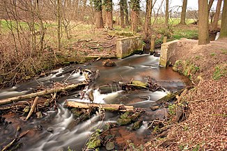
Old weir of the Landerbach near Sende |
||
| Data | ||
| Water code | DE : 312844 | |
| location | North Rhine-Westphalia , Germany | |
| River system | Ems | |
| Drain over | Ölbach → Wapel → Dalke → Ems → North Sea | |
| source | In the Senne northeast of Stukenbrock 51 ° 55 ′ 10 ″ N , 8 ° 39 ′ 8 ″ E |
|
| Source height | approx. 141 m above sea level NN | |
| muzzle | North-east of Verl in den Ölbach Coordinates: 51 ° 53 '22 " N , 8 ° 31' 26" E 51 ° 53 '22 " N , 8 ° 31' 26" E |
|
| Mouth height | approx. 92 m above sea level NN | |
| Height difference | approx. 49 m | |
| Bottom slope | approx. 4.3 ‰ | |
| length | 11.4 km | |
| Catchment area | 21.464 km² | |
| Right tributaries | Krampsbach , Dalbkebach | |
| Communities | Holte-Stukenbrock Castle and Verl | |
The Landerbach (called in the upper reaches of the Bonebach ) is an orographically right tributary of the Ölbach in North Rhine-Westphalia , Germany . It has a length of 11.4 km.
River course
The Landerbach rises as a bones stream in the Senne northeast of the village of Stukenbrock as an outflow of a spring pond. After about 1.6 kilometers, it takes up the Krampsbach, which also rises in the Senne, on the right-hand side via a reservoir and changes its name to "Landerbach".
The brook flows in a westerly direction towards Holte Castle and passes under the local motorway access to the A33 . Below Schloß Holte, the Landerbach takes on the Dalbkebach, which also flows to the right, which is a drain of the Menkhauser Bach and thus establishes a connection to this body of water. After this tributary, the Landerbach reaches the area of the Holter Forest , which it flows through on the northern edge. After a few kilometers, the Landerbach crosses the city limits to Verl and flows south past the district of Sende . In the further course, the water forms the northern edge of the Holter Forest as a transition to the agricultural meadow landscape. To the northeast of Verl, the Landerbach finally flows into the Ölbach in an area used for local recreation .
The Landerbach overcomes a height difference of 49 meters along its course, resulting in an average bed gradient of 4.3 ‰.
Flora and fauna
The Landerbach, which flows from east to west through the Holter Forest (like the Ölbach), is accompanied by alder-ash floodplain forests . Relics of alder forests can also be found locally. The water serves as a habitat for the kingfisher .
Others
On the northern edge of the Holter Forest, there are remains of old weirs in several places in the Landerbach. These were closed earlier in order to flood the adjacent meadows and fertilize the nutrient-poor soils with the suspended matter . This process was called "meadow rafting". This fertilization method was only discontinued with the advent of artificial fertilizers in the first half of the 20th century.
As the databases of the Verl municipal archive reveal, the Landerbach was also known under the name Krieftewirthsbach until the beginning of the 20th century .
