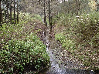
Krampsbach
| Krampsbach | ||
|
The Krampsbach near Stukenbrock |
||
| Data | ||
| Water code | DE : 3128442 | |
| location | North Rhine-Westphalia , Germany | |
| River system | Ems | |
| Drain over | Landerbach → Ölbach → Wapel → Dalke → Ems → North Sea | |
| source | Rose ponds in the Oerlinghauser Senne 51 ° 55 ′ 33 ″ N , 8 ° 38 ′ 42 ″ E |
|
| Source height | approx. 140 m above sea level NN | |
| muzzle | At Stukenbrock in Landerbach, coordinates: 51 ° 55 '6 " N , 8 ° 37' 54" E 51 ° 55 '6 " N , 8 ° 37' 54" E |
|
| Mouth height | 130 m above sea level NN | |
| Height difference | approx. 10 m | |
| Bottom slope | approx. 8.1 ‰ | |
| length | 1.2 km | |
| Communities | Oerlinghausen , Holte-Stukenbrock Castle | |
The Krampsbach is an orographically right tributary of the Landerbach in North Rhine-Westphalia , Germany . It has a length of 1.2 km.
River course
The Krampsbach rises in a wooded area within the Senne just on the Oerlinghausen district as an outflow of two successive spring basins, which are known as rose ponds .
Following the flattening of the Teutoburg Forest , the water flows off in a south-westerly direction and crosses the border to Schloss Holte-Stukenbrock within the forest area . At Gut Schlieffen, northwest of the Stukenbrock district , the Krampsbach then flows over a pond into the beinbach, which tapers from the east and is called Landerbach from this point on .
The Krampsbach overcomes a height difference of 10 meters during its flow section, resulting in an average bed gradient of 8.3 ‰.
Characteristic
The Krampsbach runs almost exclusively through wooded area and is accordingly in a largely natural state. During its course, the water is accompanied by broken forest areas and inland dunes . Above the rose ponds there is a dry valley , which is, however, shorter than in most of the neighboring Senne brooks.
