Las Piñas
|
City of Las Piñas Lungsod ng Las Piñas |
||
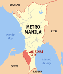
| Location of Las Piñas in the Metro Manila region | ||
|---|---|---|

|
||
| Basic data | ||
| Region : | Metro Manila | |
| Barangays : | 20th | |
| PSGC : | 137601000 | |
| Income class : | 1st income bracket | |
| Households : | 97,962 May 1, 2000 census
|
|
| Population : | 588,894 August 1, 2015 census
|
|
| Population density : | 14,177 inhabitants per km² | |
| Area : | 41.54 km² | |
| Coordinates : | 14 ° 27 ' N , 120 ° 59' E | |
| Area code : | +63 2 | |
| Mayor : | Vergel Aguilar ( NP ) | |
| Website: | www.laspinascity.gov.ph | |
| Geographical location in the Philippines | ||
|
|
||
The city of Las Piñas ( Filipino : Lungsod ng Las Piñas ) is one of the cities that make up the Philippine capital region of Metro Manila . In 2015, 588,894 people lived in Las Piñas on 41.54 km².
Districts and Barangays
Las Piñas is politically divided into 20 barangays (districts). These barangays are assigned to two districts. District 1 occupies the northwestern part of the urban area, while District 2 takes the remaining half.
District 1 of Barangays
|
District 2 Barangays
|
Personalities
- Amani Aguinaldo (* 1995), football player

