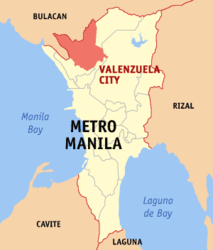
Valenzuela City
| Valenzuela City | ||
| Location of Valenzuela City in the Metro Manila Province | ||
|---|---|---|

|
||
| Basic data | ||
| Region : | Metro Manila | |
| Province : | Metro Manila | |
| Barangays : | 33 | |
| District: | 3. Metro Manila District | |
| PSGC : | 137504000 | |
| Income class : | 1st income bracket | |
| Households : |
May 1, 2000 census
|
|
| Population : | 620.422 August 1, 2015 census
|
|
| Population density : | 13,195 inhabitants per km² | |
| Area : | 47.02 km² | |
| Coordinates : | 14 ° 41 ′ N , 121 ° 0 ′ E | |
| Postal code : | 1440 | |
| Website: | The website of Valenzuela City | |
| Geographical location in the Philippines | ||
|
|
||
Valenzuela City , Tagalog : Lungsod ng Valenzuela , is a Philippine Component City in the north of the metropolitan area of Metro Manila . According to the 2015 census, Valenzuela City had 620,422 residents who lived in 33 barangays . It is classified as the first income class community in the Philippines and highly urbanized .
geography
Valenzuela City's neighboring municipalities are Malabon City in the west, Meycauayan City in the north, Caloocan-North and Quezon City in the east and Caloocan-South in the south. The topography of the city is characterized by the lowlands in the southeast of the central Luzon lowlands and the mountainous foothills of the Sierra Madre in the northeast. Many canals, some of which are navigable, cross the plains.
history
The area of Valenzuela City was an important settlement area of the Tagalog long before the Spanish colonization . The area is fertile and numerous rivers cross the area, such as the Tullahan which connects the area with the Pasig River , the northern rivers connect the area with the Pampanga . Before the arrival of the Spaniards under Miguel López de Legazpi , the area was under the rule of Rajah Sulayman . After the battle of Bangkusay on June 3, 1571, the area was incorporated into the Spanish Empire and was first called Polo. It took 17 years until the first revolt against Spanish rule emerged. With the support of the nobles, the Marhalikas, from Tondo , Polo, Pandacan, Candaba , Taguig, Misil, Caranglan, Navotas and other places, the inhabitants revolted against the Spanish sovereignty over the region, but the so-called Tondo Conspiration of the Maharlikas was put down.
After the establishment of the Archdiocese of Manila on August 14, 1595, a church was built in Catangalan and a regional administration was established. As early as 1623, Polo was separated from Catangalan, its own municipal administration was set up and the city was founded.
Barangays
|
|
|
