Candaba
| Municipality of Candaba | ||
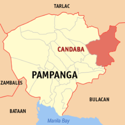
| Location of Candaba in the Pampanga Province | ||
|---|---|---|

|
||
| Basic data | ||
| Region : | Central Luzon | |
| Province : | Pampanga | |
| Barangays : | 33 | |
| District: | 4. District of Pampanga | |
| PSGC : | 035405000 | |
| Income class : | 1st income bracket | |
| Households : |
May 1, 2000 census
|
|
| Population : | 111,586 August 1, 2015 census
|
|
| Population density : | 632.6 inhabitants per km² | |
| Area : | 176.40 km² | |
| Coordinates : | 15 ° 9 ′ N , 120 ° 46 ′ E | |
| Postal code : | 2013 | |
| Geographical location in the Philippines | ||
|
|
||
Candaba is a Filipino municipality in the Pampanga Province , in Administrative Region III, Central Luzon . As of the 2015 census, Candaba had 111,586 residents living in 33 barangays . It is classified as a first income class community in the Philippines and as partially urbanized .
Candaba's neighboring communities are Santa Ana and San Luis in the west, Cabiao in the north, Baliuag in the south, San Ildefonso and San Miguel in the east. The topography of the city is characterized by flat lands . The eastern part of the municipality is located in a depression in which the Candaba river marshes spread out, an area known worldwide among ornithologists .
Barangays
|
|
|
