Lehnhausen
|
Lehnhausen
City of Gemünden (Wohra)
Coordinates: 50 ° 59 ′ 14 " N , 8 ° 55 ′ 15" E
|
|
|---|---|
| Height : | 284 (279-297) m above sea level NHN |
| Area : | 13.36 km² [LAGIS] |
| Residents : | 110 (Jan 15, 2009) |
| Population density : | 8 inhabitants / km² |
| Incorporation : | December 31, 1971 |
| Postal code : | 35285 |
| Area code : | 06453 |
|
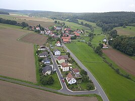
Lehnhausen from the south (September 2017)
|
|
Lehnhausen is a district of Gemünden (Wohra) in the northern Hessian district of Waldeck-Frankenberg .
geography
The place lies west of the core town Gemünden an der Holzbach in the northeast part of the castle forest . In the north-east, the state road 3077 and the Holzbach pass the village.
history
Lehnhausen was first mentioned in writing in 1240. In 1900 the small village consisted of 16 houses and the school built in 1893. In 1927 the village belonged to the Rosenthal district court and the Frankenberg tax office . In 1933 the place had 27 inhabitants.
From the village of Asel , now flooded by the Edertalsperre , the church was bought in 1914 and rebuilt as a school in 1915. In 1960 the first village community center in the district was built in Lehnhausen .
On December 31, 1971, the previously independent community Lehnhausen the course was municipal reform in Hesse on a voluntary basis in the city Gemünden at the Wohra incorporated . For Lehnhausen, as for the other parts of the city, a local district with a local advisory board and local councilor was formed.
literature
- Literature about Lehnhausen in the Hessian Bibliography
- Search for Lehnhausen in the archive portal-D of the German Digital Library
Web links
- Districts. In: Internet presence. City of Gemünden on the Wohra
- Lehnhausen, Waldeck-Frankenberg district. Historical local dictionary for Hessen. (As of April 4, 2014). In: Landesgeschichtliches Informationssystem Hessen (LAGIS).
Individual evidence
- ^ Federal Statistical Office (ed.): Historical municipality directory for the Federal Republic of Germany. Name, border and key number changes in municipalities, counties and administrative districts from May 27, 1970 to December 31, 1982 . W. Kohlhammer, Stuttgart / Mainz 1983, ISBN 3-17-003263-1 , p. 390 .
- ↑ main statute. (PDF; 873 kB) §; 6. In: Website. City of Gemünden (Wohra), accessed February 2019 .

