
Quieter mountains
| Quieter mountains | ||
|---|---|---|
 View from Steinbacher Heide to Buschberg (civil radar station), Steinmandl (military radar station) and Oberleiser Berg (observation tower). In the foreground you can see blocks of organodetritic limestone from the Ernstbrunn formation. |
||
| Highest peak | Buschberg ( 491 m above sea level ) | |
| location | Districts Mistelbach and Korneuburg , Weinviertel , Lower Austria | |
| part of | Waschbergzone (cliff zone) , Weinviertel hill country in the Carpathian foothills | |
|
||
| Coordinates | 48 ° 35 ' N , 16 ° 24' E | |
| rock | Limestone , marl limestone | |
| Age of the rock | Jura , education: Alpidic mountain formation , 17 mya | |
| particularities | Leiser Berge Nature Park | |

The Leiser Berge are several small, steep limestone mountains near Ernstbrunn in Lower Austria , they are located in the Weinviertel hill country in the foothills of the Carpathians . The highest of these is the Buschberg at 491 m, followed by the Steinberg at 462 m and the Oberleiser Berg at 457 m.
From a geological point of view, the Leiser Berge are part of the Waschberg zone and consist of limestone and marl lime .
Steppe lawns and mixed oak forests are typical for this area, which is located in the Pannonian flora province . Under climatic conditions with little precipitation, finely earthy steppes of turf developed over the Jura limestone , which are part of the Stipo-Festucetum valesiacae association . The grass steppes are dominated by narrow-leaved, mostly clump-forming grasses and have many species whose main distribution area is much further east. The patchy lawns offer space for numerous early spring annuals , which develop their entire development cycle in damp winter and early spring and survive the dry, hot summer as resistant seeds . Succulent species settle on exposed limestone cliffs and counter the drought with sophisticated protective mechanisms.
Due to the need for protection, an area of 4,500 hectares was declared a nature park in 1970 . The region includes Ladendorf , Gnadendorf , Ernstbrunn , Asparn an der Zaya , Niederleis , Oberleis and Neubau , the highest village in the Weinviertel.
photos

Oberleiser Berg

Oberleiser Berg (south-southeast view)

Buschberg with flight radar system

Oberleis from the observation tower

Panorama of the Leiser Mountains

The hard limestone blocks weather only slowly and form striking landscape elements, as here in the Steinbacher Heide.

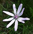
Succulent plants settle on the limestone cliffs, including the yellow flowering hot stonecrop ( Sedum acre ).

The grass steppe around the local mountain south of the Buschberg summit is part of the Stipo-Festucetum valesiacae association .

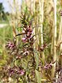
The grape germander ( Teucrium botrys ) that occurs near the local mountain is considered endangered in Austria.

The heat-loving Christ-eye elephant ( Inula oculus-christi ) is also endangered.
The cocoa-scented purple salsify ( Scorzonera purpurea ) is also endangered.

The lime-loving pasque flower ( Pulsatilla pratensis subsp. Nigricans ) is also endangered.

The lime and skeleton-rich fields are home to an interesting Segetal flora , to which the endangered scarlet adonis ( Adonis flammea ) belongs.

The (sub-) Mediterranean and long-established large Venus mirror ( Legousia speculum-veneris ) is considered endangered.
The rare spring red tooth rust ( Odontites vernus ) is endangered.

The chalk- loving through-wax rabbit's ear ( Bupleurum rotundifolium ) is also at great risk .


Individual evidence
- Entry on Leiser Berge in the Austria Forum (in the AEIOU Austria Lexicon )
- ↑ Subcarpathian: Geographical location on lehrerweb.at . Viewed July 18, 2013.
- ^ Wolfgang Willner: Pannonian steppe grasslands in Austria. In: Henryk Baumbach, Stephan Pfützenreuter (Hrsg.): Steppe habitats in Europe: Endangerment, conservation measures and protection. Thuringian Ministry of Agriculture, Forests, Environment and Nature Conservation (TMLFUN), Erfurt 2013, ISBN 978-3-00-044248-3 , p. 155. (PDF; 549 kB)
- ^ A b c d e f g h Manfred A. Fischer, Karl Oswald, Wolfgang Adler: Excursion flora for Austria, Liechtenstein and South Tyrol . 3rd, improved edition. State of Upper Austria, Biology Center of the Upper Austrian State Museums, Linz 2008, ISBN 978-3-85474-187-9 .